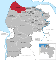
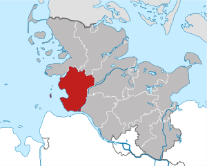
Cuxhaven (Landkreis Cuxhaven)

- German district of Lower Saxony
 Hiking in Cuxhaven
Cuxhaven, located in Lower Saxony, Germany, offers a unique hiking experience with its combination of coastal landscapes, nature reserves, and historical sites. Here are some highlights of hiking in the Cuxhaven district:
1.
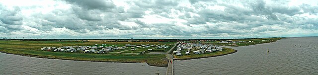
- The outskirts of Cuxhaven feature beautiful sandy beaches along the North Sea. There are numerous walking paths along the beach where you can take in views of the water, dunes, and mudflats, which are especially interesting during low tide.
2.
- A UNESCO World Heritage Site, the Wadden Sea is renowned for its unique ecosystem and the phenomenon of mudflat hiking (Wadwandern). Guided tours are available for those new to this experience, or you can explore on your own with proper guidance.
- Be cautious of tidal times, as the area can become inaccessible at high tide.
3.
- These are popular resort areas within the Cuxhaven district that offer well-marked trails along the coast and through nearby nature parks. You can hike to see local flora and fauna, particularly bird species during migration seasons.
4.
- Kehdinger Moor is another area worth exploring. The moorland provides a different landscape and is home to various bird species and marsh plants.
- The Cuxhaven Nature Reserve includes a range of habitats from mudflats to forests, allowing for diverse hiking trails.
5.
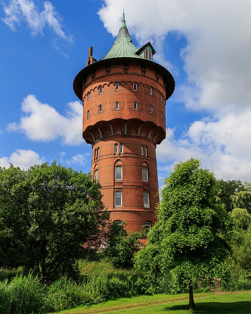
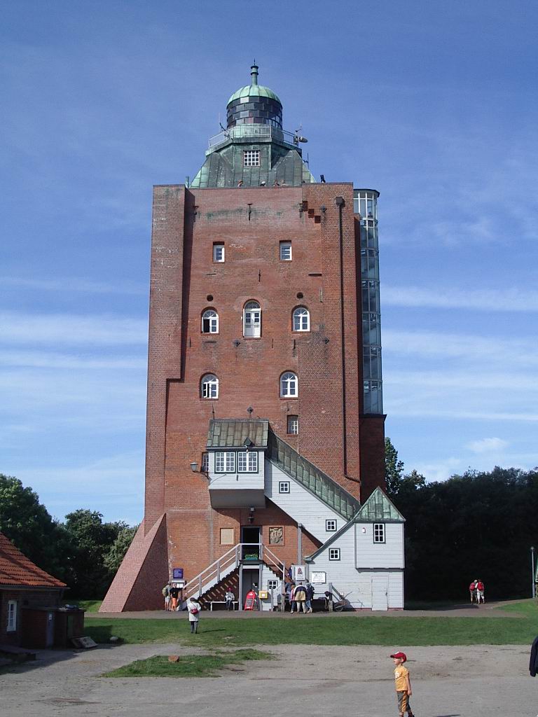
- While hiking, you can also explore historical landmarks such as the Cuxhaven Lighthouse and various forts and lookout points that offer lovely views of the North Sea.
Tips for Hiking in Cuxhaven:
- Tide Awareness: Always check tide schedules if you plan to hike on the mudflats or near the coastline, as conditions change rapidly.
- Seasonal Considerations: Spring and early summer are great for wildflowers and birdwatching, while autumn often features stunning coastal landscapes.
- Gear: Wear appropriate footwear and bring layers, as weather conditions can vary.
- Maps and Guides: Consider obtaining local hiking maps or joining guided tours to make the most of your experience.
Whether you're a seasoned hiker or a casual walker, Cuxhaven provides a stunning backdrop for outdoor activities with its peaceful nature and maritime charm.
- Country:

- Capital: Cuxhaven
- Licence Plate Code: CUX
- Coordinates: 53° 40' 12" N, 8° 49' 48" E


- GPS tracks (wikiloc): [Link]
- AboveSeaLevel: 5 м m
- Area: 2057.78 sq km
- Population: 198670
- Web site: http://www.landkreis-cuxhaven.de/
- Wikipedia en: wiki(en)
- Wikipedia: wiki(de)
- Wikidata storage: Wikidata: Q5897
- Wikipedia Commons Gallery: [Link]
- Wikipedia Commons Category: [Link]
- Wikipedia Commons Maps Category: [Link]
- Freebase ID: [/m/012wmn]
- Freebase ID: [/m/012wmn]
- Freebase ID: [/m/012wmn]
- GeoNames ID: Alt: [2939657]
- GeoNames ID: Alt: [2939657]
- GeoNames ID: Alt: [2939657]
- VIAF ID: Alt: [144241034]
- VIAF ID: Alt: [144241034]
- VIAF ID: Alt: [144241034]
- OSM relation ID: [3500495]
- OSM relation ID: [3500495]
- OSM relation ID: [3500495]
- GND ID: Alt: [4010794-2]
- GND ID: Alt: [4010794-2]
- GND ID: Alt: [4010794-2]
- archINFORM location ID: [1344]
- archINFORM location ID: [1344]
- archINFORM location ID: [1344]
- Library of Congress authority ID: Alt: [n80025238]
- Library of Congress authority ID: Alt: [n80025238]
- Library of Congress authority ID: Alt: [n80025238]
- TGN ID: [7207212]
- TGN ID: [7207212]
- TGN ID: [7207212]
- National Library of Israel ID: [000978625]
- National Library of Israel ID: [000978625]
- National Library of Israel ID: [000978625]
- NUTS code: [DE932]
- NUTS code: [DE932]
- NUTS code: [DE932]
- German district key: 03352
- German district key: 03352
- German district key: 03352
Includes regions:
Hadeln
- place in Lower Saxony, Germany
Hiking in Hadeln
Hadeln is a picturesque region located in Lower Saxony, Germany, known for its beautiful landscapes and rich natural diversity. Hiking in Hadeln offers a unique opportunity to explore its scenic beauty, quaint villages, and historical sites....
- Country:
- Coordinates: 53° 48' 0" N, 8° 54' 0" E
- GPS tracks (wikiloc): [Link]
- Area: 84.69 sq km
Beverstedt
- former collective municipality in the district of Cuxhaven, in Lower Saxony, Germany
Hiking in Beverstedt
Beverstedt, located in the Samtgemeinde of Beverstedt in Lower Saxony, Germany, offers a variety of outdoor activities, including hiking. While it may not be as well-known for hiking trails as some of Germany's more mountainous regions, it does have some charming routes that allow you to explore the natural beauty of the area....
- Country:
- Coordinates: 53° 26' 6" N, 8° 49' 9" E
- GPS tracks (wikiloc): [Link]
- Area: 197.60 sq km
- Web site: [Link]


Geestland
- town in Germany
Hiking in Geestland
Geestland is a picturesque region located in Lower Saxony, Germany, known for its unique landscapes and hiking opportunities. While the area may not be as popular as some of Germany’s more renowned hiking destinations, it offers peaceful trails and scenic views that are perfect for nature lovers and those seeking a quieter experience....
- Country:
- Postal Code: 27624; 27607
- Local Dialing Code: 04765; 04756; 04745; 04743; 04742; 0471; 04708; 04707; 04704
- Licence Plate Code: CUX
- Coordinates: 53° 38' 0" N, 8° 45' 0" E
- GPS tracks (wikiloc): [Link]
- AboveSeaLevel: 10 м m
- Area: 356.58 sq km
- Population: 30873
- Web site: [Link]

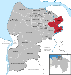
Wurster Nordseeküste
- municipality in Cuxhaven district, Lower Saxony, Germany
Hiking in Wurster Nordseeküste
Wurster Nordseeküste, located in Lower Saxony, Germany, is a beautiful coastal region along the North Sea. While it’s primarily known for its flat landscapes, sandy beaches, and charming villages, there are plenty of opportunities for hiking and outdoor activities in the area....
- Country:
- Postal Code: 27639
- Local Dialing Code: 04742; 04741; 04705
- Licence Plate Code: CUX
- Coordinates: 53° 47' 0" N, 8° 36' 0" E
- GPS tracks (wikiloc): [Link]
- AboveSeaLevel: 21 м m
- Area: 182.08 sq km
- Population: 17094
- Web site: [Link]
Land Wursten
- Samtgemeinde in Lower Saxony
Hiking in Land Wursten
Land Wursten, located in Lower Saxony, Germany, is an area known for its scenic landscapes and proximity to the North Sea. While it may not be as mountainous as some other hiking destinations, it offers unique walking opportunities through its coastal landscapes, heathlands, and along dikes....
- Country:
- Coordinates: 53° 42' 0" N, 8° 33' 0" E
- GPS tracks (wikiloc): [Link]
- Area: 116.97 sq km
Cuxhaven
- town in Lower Saxony, Germany
Hiking in Cuxhaven
Cuxhaven, located on the North Sea coast of Germany, offers a unique combination of coastal landscapes, scenic views, and a variety of hiking opportunities. Here are some highlights and tips for hiking in this region:...
- Country:
- Postal Code: 27478; 27476; 27474; 27472
- Local Dialing Code: 04724; 04723; 04722; 04721
- Licence Plate Code: CUX
- Coordinates: 53° 52' 18" N, 8° 41' 27" E
- GPS tracks (wikiloc): [Link]
- AboveSeaLevel: 5 м m
- Area: 161.91 sq km
- Population: 48551
- Web site: [Link]
Sietland
- place in Lower Saxony, Germany
Hiking in Sietland
Sietland is not a widely recognized hiking destination, and it may refer to a specific region or locality that isn't well-documented in hiking resources. However, if you're interested in hiking in a specific area within Sietland or if you meant a different place altogether, I can provide some general hiking tips and advice that are applicable to various hiking locations....
- Country:
- Coordinates: 53° 44' 0" N, 8° 55' 0" E
- GPS tracks (wikiloc): [Link]

Land Hadeln
- Samtgemeinde in Lower Saxony
Hiking in Land Hadeln
Land Hadeln, located in Lower Saxony, Germany, is a picturesque area known for its natural beauty and accessibility for outdoor activities, including hiking. The region offers a mix of landscapes, from lush meadows and forests to wetlands, making it an ideal destination for nature lovers and hikers....
- Country:
- Coordinates: 53° 48' 28" N, 8° 54' 11" E
- GPS tracks (wikiloc): [Link]
- Population: 27066
- Web site: [Link]
Hagen
- Samtgemeinde in Lower Saxony
Hiking in Hagen
Hagen, located in the Lower Saxony region of Germany, is known for its beautiful landscapes and hiking opportunities. In the Samtgemeinde (a collective municipality) of Hagen, you can find a variety of trails that cater to different skill levels and preferences....


Am Dobrock
- former Samtgemeinde in Lower Saxony
Hiking in Am Dobrock
Am Dobrock is a picturesque area located in Germany, particularly known for its natural beauty and outdoor activities. The region is characterized by rolling hills, lush forests, and scenic views, making it a great destination for hiking....
- Country:
- Coordinates: 53° 46' 15" N, 9° 3' 30" E
- GPS tracks (wikiloc): [Link]
- Area: 178.11 sq km
- Web site: [Link]


Börde Lamstedt
- Samtgemeinde in Lower Saxony
Hiking in Börde Lamstedt
Börde Lamstedt is a lovely region in Lower Saxony, Germany, known for its picturesque landscapes and rural charm. It offers various hiking opportunities for both beginners and experienced hikers. Here are some things to keep in mind when planning a hike in this area:...
- Country:
- Coordinates: 53° 37' 54" N, 9° 5' 55" E
- GPS tracks (wikiloc): [Link]
- Area: 177.08 sq km
- Population: 6062
- Web site: [Link]
Bederkesa
- Samtgemeinde in Lower Saxony
Hiking in Bederkesa
Bederkesa, located in the Samtgemeinde Bederkesa in Lower Saxony, Germany, offers a range of hiking opportunities suited to different skill levels and preferences. The region is characterized by beautiful landscapes, including moors, forests, and picturesque lakes, making it an excellent destination for outdoor enthusiasts....
- Country:
- Coordinates: 53° 37' 30" N, 8° 50' 29" E
- GPS tracks (wikiloc): [Link]
- Area: 234.60 sq km

Samtgemeinde Hemmoor
- Samtgemeinde in Lower Saxony
Hiking in Samtgemeinde Hemmoor
Hemmoor, a town located in Lower Saxony, Germany, offers a range of outdoor activities including hiking. The surrounding Samtgemeinde (collective municipality) has numerous trails that cater to different skill levels and preferences....
- Country:
- Coordinates: 53° 42' 0" N, 9° 7' 0" E
- GPS tracks (wikiloc): [Link]
- Population: 13933
- Web site: [Link]


Schiffdorf
- municipality of Germany
Hiking in Schiffdorf
Schiffdorf is a municipality in the district of Cuxhaven in Lower Saxony, Germany. While it may not be as widely known as some larger hiking destinations, it offers opportunities for outdoor enthusiasts to explore. Here are some key points to consider if you're thinking about hiking in and around Schiffdorf:...
- Country:
- Postal Code: 27619
- Local Dialing Code: 04749; 0471; 04706; 04704; 04703
- Licence Plate Code: CUX
- Coordinates: 53° 32' 0" N, 8° 39' 0" E
- GPS tracks (wikiloc): [Link]
- AboveSeaLevel: 8 м m
- Area: 113.55 sq km
- Population: 14182
- Web site: [Link]


Beverstedt
- municipality in Lower Saxony, Germany
Hiking in Beverstedt
Beverstedt, a picturesque town located in Lower Saxony, Germany, offers various opportunities for hiking enthusiasts. While it may not be as widely known as some larger hiking destinations, its surrounding natural landscapes provide a serene environment for outdoor activities....
- Country:
- Postal Code: 27432; 27616
- Local Dialing Code: 04747
- Licence Plate Code: CUX
- Coordinates: 53° 26' 3" N, 8° 49' 9" E
- GPS tracks (wikiloc): [Link]
- AboveSeaLevel: 12 м m
- Area: 197.6 sq km
- Population: 13526
- Web site: [Link]


Loxstedt
- municipality in Cuxhaven district, Lower Saxony, Germany
Hiking in Loxstedt
Loxstedt, a small town in Lower Saxony, Germany, is surrounded by beautiful landscapes that are ideal for hiking and exploring nature. While it may not have the dramatic mountain ranges of other hiking destinations, the region offers a variety of scenic trails suitable for all levels of hikers. Here are some highlights for hiking in and around Loxstedt:...
- Country:
- Postal Code: 27612
- Local Dialing Code: 04744; 04740; 0471; 04703
- Licence Plate Code: CUX
- Coordinates: 53° 28' 0" N, 8° 39' 0" E
- GPS tracks (wikiloc): [Link]
- AboveSeaLevel: 7 м m
- Area: 141.24 sq km
- Population: 16115
- Web site: [Link]


Hagen im Bremischen
- municipality of Germany
Hiking in Hagen im Bremischen
Hagen im Bremischen is a charming municipality located in Lower Saxony, Germany, situated near the northern edge of the Lüneburg Heath. While it may not be as well-known as other hiking destinations in Germany, it offers opportunities for outdoor activities, including hiking....
- Country:
- Postal Code: 27628
- Local Dialing Code: 04746
- Licence Plate Code: CUX
- Coordinates: 53° 22' 0" N, 8° 39' 0" E
- GPS tracks (wikiloc): [Link]
- AboveSeaLevel: 14 м m
- Area: 197.43 sq km
- Population: 11110
- Web site: [Link]
Shares border with regions:

Hamburg-Mitte
- district of Hamburg, Germany
Hiking in Hamburg-Mitte
Hiking in Hamburg-Mitte offers a unique blend of urban exploration, historical sites, and beautiful green spaces. While the area is predominantly urban, there are several parks and nature areas where you can enjoy some fresh air and scenic views. Here are a few highlights and suggestions for hiking and outdoor activities in Hamburg-Mitte:...
- Country:
- Coordinates: 53° 33' 1" N, 9° 59' 39" E
- GPS tracks (wikiloc): [Link]
- AboveSeaLevel: 11 м m
- Area: 142.2 sq km
- Population: 301550


Bremerhaven
- German city in the Free Hanseatic City of Bremen
Hiking in Bremerhaven
Bremerhaven, located in northern Germany along the North Sea coast, is not typically known as a major hiking destination compared to areas with more rugged terrain. However, it offers some pleasant walking and hiking opportunities, particularly for those who enjoy coastal scenery and urban exploration....
- Country:
- Postal Code: 27501–27580; 2850
- Local Dialing Code: 0471
- Licence Plate Code: HB
- Coordinates: 53° 33' 0" N, 8° 35' 0" E
- GPS tracks (wikiloc): [Link]
- AboveSeaLevel: 2 м m
- Area: 93.66 sq km
- Population: 113034
- Web site: [Link]

Dithmarschen
- German district
Hiking in Dithmarschen
Dithmarschen, located in northern Germany, is known for its unique landscapes, rich history, and diverse outdoor activities, making it a great destination for hiking enthusiasts. Here are some highlights of hiking in this region:...
- Country:
- Capital: Heide
- Licence Plate Code: HEI
- Coordinates: 54° 4' 48" N, 9° 4' 48" E
- GPS tracks (wikiloc): [Link]
- Web site: [Link]


Stade
- German district of Lower Saxony
Hiking in Stade
Stade, located in Lower Saxony, Germany, offers a range of hiking opportunities that allow you to explore its picturesque natural landscapes, historical sites, and charming small towns. Here are some highlights for hiking in the Stade district:...
- Country:
- Licence Plate Code: STD
- Coordinates: 53° 34' 48" N, 9° 25' 12" E
- GPS tracks (wikiloc): [Link]
- AboveSeaLevel: 1 м m
- Area: 1266.00 sq km
- Population: 201638
- Web site: [Link]


Rotenburg (Wümme)
- German district in Lower Saxony
Hiking in Rotenburg (Wümme)
Rotenburg (district), located in Lower Saxony, Germany, offers various hiking opportunities, particularly for those interested in exploring scenic landscapes and natural beauty. Here are some highlights and suggestions for hiking in this region:...
- Country:
- Licence Plate Code: ROW; BRV
- Coordinates: 53° 15' 0" N, 9° 19' 48" E
- GPS tracks (wikiloc): [Link]
- AboveSeaLevel: 28 м m
- Population: 163372
- Web site: [Link]


Osterholz
- district in Lower Saxony, Germany
Hiking in Osterholz
Osterholz, located in Lower Saxony, Germany, offers a variety of hiking opportunities for outdoor enthusiasts. The region is characterized by its beautiful landscapes, including forests, heathlands, and rivers, providing a picturesque setting for hikers. Here are some highlights and tips for hiking in Osterholz:...
- Country:
- Capital: Osterholz-Scharmbeck
- Licence Plate Code: OHZ
- Coordinates: 53° 15' 0" N, 8° 49' 48" E
- GPS tracks (wikiloc): [Link]
- AboveSeaLevel: 3 м m
- Area: 650.73 sq km
- Population: 112695
- Web site: [Link]


Wesermarsch
- district in Lower Saxony, Germany
Hiking in Wesermarsch
Wesermarsch is a fascinating region in Lower Saxony, Germany, known for its flat landscapes, unique marsh ecosystems, and rich cultural heritage. While it may not be as mountainous as other hiking destinations, it offers a variety of hiking trails suitable for all levels, especially for those who enjoy tranquil walks in nature and picturesque views....
- Country:
- Capital: Brake
- Licence Plate Code: BRA
- Coordinates: 53° 19' 48" N, 8° 19' 48" E
- GPS tracks (wikiloc): [Link]
- Area: 821.87 sq km
- Population: 89282
- Web site: [Link]