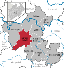
Witten (Witten)

- town in the district of Ennepe-Ruhr-Kreis, in North Rhine-Westphalia, Germany
 Hiking in Witten
Witten, located in North Rhine-Westphalia, Germany, offers a variety of hiking opportunities that showcase the region's natural beauty and historical sites. Here are some highlights for hiking in and around Witten:
Trails and Nature Areas
-
Ruhr Valley Trails: Witten is situated along the Ruhr River, which features trails that are ideal for both leisurely strolls and more vigorous hikes. The scenic views of the river and surrounding landscapes make for enjoyable nature walks.
-
Hiking in Witten's Forests: The nearby forests, such as the Witten Woods, provide well-marked trails and paths leading through dense woodlands. These areas are perfect for experiencing the local flora and fauna, as well as the chance to spot wildlife.
-
Höhenweg Trail: This is a more challenging trail that runs through the surrounding hills and offers stunning views of Witten and the Ruhr area. The trail provides a good workout and an opportunity to connect with nature.
-
Nearby Natural Areas: Just a short drive from Witten, you can access larger natural parks and hiking areas, such as the Sauerland region, which boasts a network of hiking routes with more rugged terrains and beautiful panoramic views.
Historical Sites
Hiking in Witten is not just about nature; you can also explore historical landmarks along some trails:
-
Burg Blankenstein: This medieval castle is located just outside Witten and offers a fascinating glimpse into history as well as some great viewpoints over the Ruhr Valley.
-
Industrial Heritage Trails: Witten is part of the Ruhrgebiet, a former industrial heartland, and several hiking trails take you past remnants of its industrial past. Interpretive signs along the way help you understand the region's industrial history.
Tips for Hikers
-
Weather Preparation: Always check the weather forecast before heading out, as conditions can change. Dress in layers and bring rain gear if there’s a chance of showers.
-
Trail Maps: Carry a map or ensure you have a reliable hiking app to guide you along the paths. Some trails may be less well-marked than others.
-
Stay Hydrated: Bring enough water, especially during warmer months, as some trails might not have easy access to fresh water.
-
Respect Nature: Follow Leave No Trace principles. Stay on marked paths, and be considerate of local wildlife and fellow hikers.
Witten’s combination of beautiful nature, historical significance, and varied hiking trails makes it a great destination for hikers of all experience levels. Whether you're looking for a casual stroll or a more challenging hike, you’ll find plenty of options to enjoy in this charming German town.
- Country:

- Postal Code: 58456; 58455; 58454; 58453; 58452
- Local Dialing Code: 02302
- Coordinates: 51° 26' 0" N, 7° 20' 0" E


- GPS tracks (wikiloc): [Link]
- AboveSeaLevel: 104 м m
- Area: 72.37 sq km
- Population: 96565
- Web site: https://www.witten.de/
- Wikipedia en: wiki(en)
- Wikipedia: wiki(de)
- Wikidata storage: Wikidata: Q3764
- Wikipedia Commons Gallery: [Link]
- Wikipedia Commons Category: [Link]
- Wikipedia Commons Maps Category: [Link]
- Freebase ID: [/m/01l247]
- GeoNames ID: Alt: [6557666]
- BnF ID: [12257751b]
- VIAF ID: Alt: [137176477]
- OSM relation ID: [162826]
- GND ID: Alt: [4066638-4]
- archINFORM location ID: [10776]
- Library of Congress authority ID: Alt: [n50062316]
- MusicBrainz area ID: [044a2f0b-cc42-458b-8a86-81f89131c622]
- WOEID: [707286]
- SUDOC authorities ID: [031344275]
- Encyclopædia Britannica Online ID: [place/Witten]
- Facebook Places ID: [111526388866101]
- Great Russian Encyclopedia Online ID: [1917164]
- DMOZ ID: Alt: [World/Deutsch/Regional/Europa/Deutschland/Nordrhein-Westfalen/Landkreise/Ennepe-Ruhr-Kreis/Städte_und_Gemeinden/Witten/]
- National Library of Israel ID: [000971793]
- YouTube channel ID: [UCiuFrWImogwbHqiQ_AJQ67Q]
- Facebook ID: Alt: [171926106219255]
- FAST ID: [1202923]
- Foursquare venue ID: [4c5c775d7735c9b6b85e8c72]
- Open Library subject ID: [place:witten_(germany)]
- German municipality key: 05954036
Includes regions:

Witten-Mitte
- quarter of Witten, North Rhine-Westfalia, Germany
Hiking in Witten-Mitte
Witten-Mitte, located in North Rhine-Westphalia, Germany, isn't traditionally known as a prime hiking destination, as it is more of an urban area with nearby natural attractions. However, it serves as a great starting point for exploring nearby trails and natural sites....
- Country:
- Postal Code: 58452
- Local Dialing Code: 02302
- Coordinates: 51° 26' 23" N, 7° 20' 14" E
- GPS tracks (wikiloc): [Link]
- Area: 11.4090 sq km
- Population: 33553

Düren
- quarter of Witten, North Rhine-Westfalia, Germany
Hiking in Düren
Düren, located in North Rhine-Westphalia, Germany, offers a range of hiking opportunities, particularly in the surrounding natural landscapes. While Düren itself may not be a significant hiking destination, nearby areas such as the Eifel National Park and the surrounding hills provide excellent trails for different skill levels....
- Country:
- Postal Code: 58454
- Local Dialing Code: 02302
- Coordinates: 51° 28' 24" N, 7° 21' 23" E
- GPS tracks (wikiloc): [Link]
- Area: 1.6969 sq km

Annen
- quarter of Witten, North Rhine-Westfalia, Germany
Hiking in Annen
Witten-Annen is a charming district in the city of Witten, located in North Rhine-Westphalia, Germany. The area offers a variety of hiking opportunities, particularly appealing for those who enjoy exploring natural landscapes....
- Country:
- Postal Code: 58453
- Local Dialing Code: 02302
- Coordinates: 51° 26' 59" N, 7° 22' 32" E
- GPS tracks (wikiloc): [Link]
- Area: 12.1072 sq km
- Population: 18250

Bommern
- quarter of Witten, North Rhine-Westfalia, Germany
Hiking in Bommern
Bommern is a district in the city of Witten, located in North Rhine-Westphalia, Germany. While it may not be as widely recognized as other hiking destinations in Germany, it offers some lovely outdoor experiences due to its proximity to several natural parks and hiking trails....
- Country:
- Postal Code: 58452
- Local Dialing Code: 02302
- Coordinates: 51° 25' 29" N, 7° 20' 16" E
- GPS tracks (wikiloc): [Link]
- Area: 6.1316 sq km
- Population: 8458

Heven
- quarter of Witten, North Rhine-Westfalia, Germany
Hiking in Heven
It seems like there may be a typo in your question. If you meant "Heaven," please clarify more about what you are referring to, as "Heaven" isn't a specific location for hiking. However, if you meant a specific area, national park, or even a state known for its picturesque trails, please provide more details....
- Country:
- Postal Code: 58455
- Local Dialing Code: 02302
- Coordinates: 51° 26' 25" N, 7° 18' 31" E
- GPS tracks (wikiloc): [Link]
- Area: 5.9668 sq km
- Population: 11674

Rüdinghausen
- quarter of Witten, North Rhine-Westfalia, Germany
Hiking in Rüdinghausen
Rüdinghausen, located in Germany, offers a variety of scenic hiking opportunities that cater to different skill levels. Nestled in the region of North Rhine-Westphalia, it's surrounded by beautiful landscapes, including hills, forests, and meadows. Here are some highlights and tips for hiking in Rüdinghausen:...
- Country:
- Postal Code: 58453
- Local Dialing Code: 02302
- Coordinates: 51° 27' 1" N, 7° 24' 1" E
- GPS tracks (wikiloc): [Link]
- Area: 7.3524 sq km
- Population: 6632

Stockum
- quarter of Witten, North Rhine-Westfalia, Germany
Hiking in Stockum
Witten-Stockum is a beautiful area located in North Rhine-Westphalia, Germany, known for its picturesque landscapes and well-maintained hiking trails. This region boasts a mix of natural beauty, including forests, meadows, and rivers, making it an excellent destination for outdoor enthusiasts....
- Country:
- Postal Code: 58454
- Local Dialing Code: 02302
- Coordinates: 51° 28' 0" N, 7° 22' 0" E
- GPS tracks (wikiloc): [Link]
- AboveSeaLevel: 158 м m
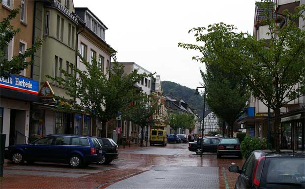
Herbede
- quarter of Witten, North Rhine-Westfalia, Germany
Hiking in Herbede
Herbede is a district located in the city of Wetter in North Rhine-Westphalia, Germany. It's surrounded by beautiful natural landscapes, making it an appealing destination for hiking enthusiasts. Here are some elements to consider while hiking in this area:...
- Country:
- Postal Code: 58452
- Local Dialing Code: 02302
- Coordinates: 51° 25' 20" N, 7° 16' 54" E
- GPS tracks (wikiloc): [Link]
- Area: 23.9680 sq km
- Population: 13111
Shares border with regions:


Herdecke
- town in Ennepe-Ruhr-Kreis, North Rhine-Westphalia, Germany
Hiking in Herdecke
Herdecke is a charming town located in North Rhine-Westphalia, Germany, situated near the Ruhr River and surrounded by picturesque landscapes, making it a great destination for hiking enthusiasts. The region is characterized by rolling hills, forests, and scenic views, providing a variety of trails for different skill levels....
- Country:
- Postal Code: 58313
- Local Dialing Code: 02330
- Licence Plate Code: EN
- Coordinates: 51° 24' 0" N, 7° 26' 0" E
- GPS tracks (wikiloc): [Link]
- AboveSeaLevel: 150 м m
- Area: 22.4 sq km
- Population: 22836
- Web site: [Link]
Sprockhövel
- town in Ennepe-Ruhr-Kreis, North Rhine-Westphalia, Germany
Hiking in Sprockhövel
Sprockhövel is a charming town located in North Rhine-Westphalia, Germany, and is surrounded by beautiful landscapes that are ideal for hiking enthusiasts. Here are some highlights and tips for hiking in the Sprockhövel area:...
- Country:
- Postal Code: 45549
- Local Dialing Code: 0202; 02324; 02339
- Licence Plate Code: EN, WIT
- Coordinates: 51° 21' 0" N, 7° 15' 0" E
- GPS tracks (wikiloc): [Link]
- AboveSeaLevel: 219 м m
- Area: 48 sq km
- Population: 24783
- Web site: [Link]


Wetter (Ruhr)
- town in the district of Ennepe-Ruhr-Kreis, in North Rhine-Westphalia, Germany
Hiking in Wetter (Ruhr)
Wetter (Ruhr) is a charming municipality located in the North Rhine-Westphalia region of Germany, offering a variety of outdoor recreation opportunities, including hiking. Nestled in the Ruhr area, it features scenic landscapes that appeal to outdoor enthusiasts. Here are some key points about hiking in Wetter (Ruhr):...
- Country:
- Postal Code: 58300
- Local Dialing Code: 02335
- Licence Plate Code: EN
- Coordinates: 51° 23' 17" N, 7° 23' 42" E
- GPS tracks (wikiloc): [Link]
- AboveSeaLevel: 110 м m
- Area: 31.47 sq km
- Population: 27628
- Web site: [Link]


Dortmund
- town in North Rhine-Westphalia, Germany
Hiking in Dortmund
Dortmund, located in the North Rhine-Westphalia region of Germany, is not only known for its industrial heritage but also offers various opportunities for hiking and enjoying nature. Here are some highlights and tips for hiking in Dortmund:...
- Country:
- Postal Code: 44135–44388
- Local Dialing Code: 02304; 0231
- Licence Plate Code: DO
- Coordinates: 51° 30' 50" N, 7° 27' 55" E
- GPS tracks (wikiloc): [Link]
- AboveSeaLevel: 86 м m
- Area: 280.71 sq km
- Population: 585813
- Web site: [Link]

Bochum
- city in North Rhine-Westphalia, Germany
Hiking in Bochum
Bochum, located in the North Rhine-Westphalia region of Germany, is not traditionally known as a hiking destination, but it offers some interesting opportunities for outdoor enthusiasts. Here are a few highlights for hiking in and around Bochum:...
- Country:
- Postal Code: 44701–44894
- Local Dialing Code: 02327; 0234
- Licence Plate Code: BO
- Coordinates: 51° 29' 0" N, 7° 13' 0" E
- GPS tracks (wikiloc): [Link]
- AboveSeaLevel: 100 м m
- Area: 145.66 sq km
- Population: 364920
- Web site: [Link]


Hattingen
- town in the district of Ennepe-Ruhr-Kreis, in North Rhine-Westphalia, Germany
Hiking in Hattingen
Hattingen, located in North Rhine-Westphalia, Germany, is an excellent destination for hiking enthusiasts. This picturesque town, known for its medieval architecture and beautiful natural landscapes, offers a variety of trails that cater to different skill levels. Here are some highlights of hiking in Hattingen:...
- Country:
- Postal Code: 45529; 45527; 45525
- Local Dialing Code: 02324
- Licence Plate Code: EN, WIT
- Coordinates: 51° 23' 57" N, 7° 11' 9" E
- GPS tracks (wikiloc): [Link]
- AboveSeaLevel: 90 м m
- Area: 71.39 sq km
- Population: 54628
- Web site: [Link]