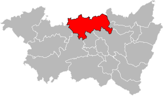
arrondissement of Épinal (arrondissement d'Épinal)

- arrondissement of France
- Country:

- Capital: Épinal
- Coordinates: 48° 10' 0" N, 6° 30' 0" E


- GPS tracks (wikiloc): [Link]
- Area: 3098 sq km
- Population: 215444
- Wikipedia en: wiki(en)
- Wikipedia: wiki(fr)
- Wikidata storage: Wikidata: Q702854
- Freebase ID: [/m/0956pk]
- GeoNames ID: Alt: [3020034]
- INSEE arrondissement code: [881]
- GNS Unique Feature ID: -1425322
Includes regions:

canton of Bains-les-Bains
- canton of France
- Country:
- Capital: Bains-les-Bains
- Coordinates: 48° 0' 7" N, 6° 15' 17" E
- GPS tracks (wikiloc): [Link]


canton of Bruyères
- canton of France
- Country:
- Capital: Bruyères
- Coordinates: 48° 12' 38" N, 6° 43' 10" E
- GPS tracks (wikiloc): [Link]
- Population: 20259

canton of Charmes
- canton of France
- Country:
- Capital: Charmes
- Coordinates: 48° 22' 17" N, 6° 17' 37" E
- GPS tracks (wikiloc): [Link]
- Population: 21083

canton of Châtel-sur-Moselle
- canton of France
- Country:
- Capital: Châtel-sur-Moselle
- Coordinates: 48° 17' 35" N, 6° 26' 7" E
- GPS tracks (wikiloc): [Link]


canton of Le Thillot
- canton of France
- Country:
- Capital: Le Thillot
- Coordinates: 47° 52' 44" N, 6° 45' 56" E
- GPS tracks (wikiloc): [Link]
- Population: 18140

canton of Plombières-les-Bains
- canton of France
- Country:
- Capital: Plombières-les-Bains
- Coordinates: 47° 57' 54" N, 6° 29' 12" E
- GPS tracks (wikiloc): [Link]
canton of Rambervillers
- canton of France
- Country:
- Capital: Rambervillers
- Coordinates: 48° 20' 46" N, 6° 38' 7" E
- GPS tracks (wikiloc): [Link]
canton of Saulxures-sur-Moselotte
- canton of France
- Country:
- Capital: Saulxures-sur-Moselotte
- Coordinates: 47° 56' 57" N, 4° 46' 21" E
- GPS tracks (wikiloc): [Link]


canton of Remiremont
- canton of France
- Country:
- Capital: Remiremont
- Coordinates: 48° 3' 33" N, 6° 38' 11" E
- GPS tracks (wikiloc): [Link]
- Population: 25439