arrondissement of Forcalquier (arrondissement de Forcalquier)
- arrondissement of France
 Hiking in arrondissement of Forcalquier
The Arrondissement of Forcalquier, located in the Alpes-de-Haute-Provence department in southeastern France, is a fantastic hiking destination known for its stunning landscapes, rich history, and diverse ecosystems. Here are some key points to consider if you're planning to hike in this area:
Scenic Landscapes
-
Natural Beauty: The region offers a variety of terrains, including rolling hills, rocky outcrops, and lush valleys. The lavender fields in summer create vibrant landscapes, and the nearby Luberon National Park provides picturesque views.
-
Durance River: The trails along the Durance River provide beautiful riverside hikes, with opportunities to enjoy the flora and fauna.
-
Montagne de Lure: This mountain range offers numerous trails with varying difficulty levels and rewards hikers with panoramic views of the surrounding countryside.
Hiking Trails
-
GR Trails: The Grande Randonnée (GR) trails in the area provide extensive hiking options, connecting various villages and natural landmarks.
-
Local Trails: There are numerous marked trails around Forcalquier, suitable for different skill levels. You can find family-friendly walks as well as challenging hikes.
-
Heritage Routes: Some trails incorporate historical sites, including ancient ruins, churches, and villages, allowing hikers to experience both nature and culture.
Flora and Fauna
The region is home to diverse wildlife and plant species, particularly in the natural parks. Look out for sage, thyme, and various southern French flora, as well as opportunities to spot birds and other wildlife.
Preparation and Safety
-
Gear: Ensure you have proper hiking gear, including sturdy boots, weather-appropriate clothing, and enough water and snacks.
-
Navigation: Although many trails are well-marked, it’s wise to carry a map or use a GPS application on your phone to stay oriented.
-
Local Knowledge: Consider contacting local hiking clubs or guides for tips and to enhance your experience with guided hikes.
Best Time to Hike
The ideal time for hiking in the Arrondissement of Forcalquier is in spring (April to June) and fall (September to October) when temperatures are mild, and the landscapes are particularly beautiful. Summer can be quite hot, while winter hikes may require additional gear and precautions.
Conclusion
Hiking in the Arrondissement of Forcalquier can be an unforgettable experience filled with natural beauty, cultural exploration, and the joy of outdoor activity. Make sure to plan ahead, respect the environment, and enjoy the stunning trails this area has to offer!
- Country:

- Capital: Forcalquier
- Coordinates: 44° 5' 0" N, 5° 50' 0" E


- GPS tracks (wikiloc): [Link]
- Area: 2112 sq km
- Population: 95312
- Wikipedia en: wiki(en)
- Wikipedia: wiki(fr)
- Wikidata storage: Wikidata: Q282593
- Freebase ID: [/m/095kh4]
- GeoNames ID: Alt: [3017797]
- INSEE arrondissement code: [044]
- GNS Unique Feature ID: -1427566
Includes regions:

canton of Manosque-Sud-Ouest
- canton of France (until March 2015)
Hiking in canton of Manosque-Sud-Ouest
Canton de Manosque-Sud-Ouest is a beautiful region located in the Alpes-de-Haute-Provence department in southeastern France. Known for its stunning landscapes, picturesque villages, and diverse ecosystems, this area offers plenty of opportunities for hiking enthusiasts....

canton of Volonne
- canton of France (until March 2015)
Hiking in canton of Volonne
Hiking in the Canton of Volonne, located in the Alpes-de-Hautes-Provence department in southeastern France, offers a variety of picturesque landscapes and trails suitable for different skill levels. Here are some highlights and tips for hiking in the area:...

canton of Noyers-sur-Jabron
- canton of France (until March 2015)
Hiking in canton of Noyers-sur-Jabron
The Canton of Noyers-sur-Jabron, located in the Alpes-de-Haute-Provence region of southeastern France, is known for its stunning natural landscapes, charming villages, and a variety of hiking trails suitable for all levels of hikers....
- Country:
- Capital: Noyers-sur-Jabron
- Coordinates: 44° 10' 11" N, 5° 52' 56" E
- GPS tracks (wikiloc): [Link]


canton of Sisteron
- canton of France
Hiking in canton of Sisteron
The Canton of Sisteron, located in the Alpes-de-Haute-Provence in southeastern France, offers some stunning hiking opportunities, largely due to its diverse landscapes, from rugged mountains to lush valleys. Here are some highlights to consider when hiking in this area:...
- Country:
- Capital: Sisteron
- Coordinates: 44° 11' 28" N, 5° 56' 50" E
- GPS tracks (wikiloc): [Link]
- Population: 12624
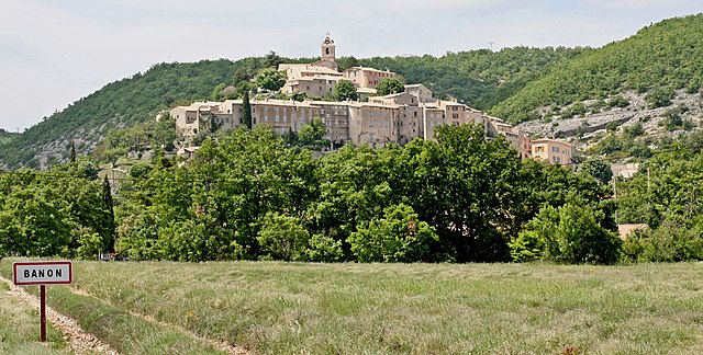
canton of Banon
- canton of France
Hiking in canton of Banon
Hiking in the Canton of Banon, located in the Alpes-de-Haute-Provence region of France, offers a unique blend of beautiful landscapes, serene nature, and cultural heritage. Here are some highlights and tips for hiking in this area:...
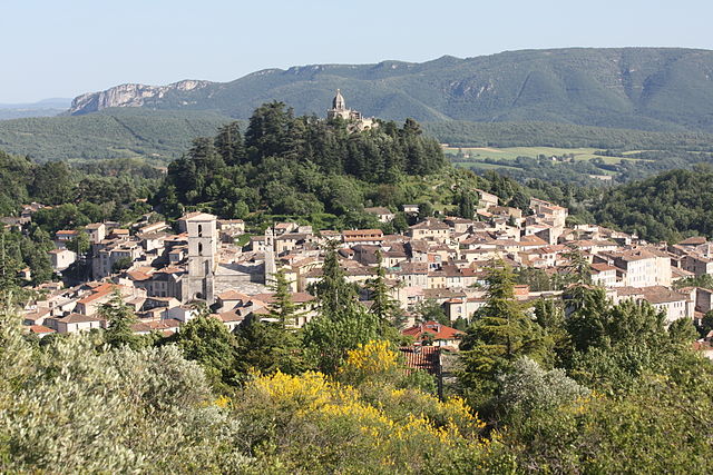

canton of Forcalquier
- canton of France
Hiking in canton of Forcalquier
Hiking in the Canton of Forcalquier, located in the Alpes-de-Haute-Provence region of southeastern France, offers a beautiful blend of scenic landscapes, historical sites, and diverse trails suitable for all levels of hikers. Here are some highlights of hiking in this region:...
- Country:
- Capital: Forcalquier
- Coordinates: 43° 57' 36" N, 5° 46' 50" E
- GPS tracks (wikiloc): [Link]
- Population: 11063
canton of Manosque-Nord
- canton of France
Hiking in canton of Manosque-Nord
Canton de Manosque-Nord, located in the Alpes-de-Haute-Provence region of southern France, is a fantastic area for hiking enthusiasts. The region is characterized by its diverse landscapes, which include rolling hills, rocky outcrops, and scenic views of the surrounding countryside. Here are some highlights and tips for hiking in this beautiful area:...
canton of Manosque-Sud-Est
- canton of France
Hiking in canton of Manosque-Sud-Est
Canton de Manosque-Sud-Est, located in the Alpes-de-Haute-Provence department in southeastern France, offers a variety of beautiful hiking opportunities. The region is characterized by its diverse landscapes, including rolling hills, rocky terrain, and stunning views of the surrounding mountains and valleys. Here are some highlights for hiking in this area:...

canton of Peyruis
- canton of France
Hiking in canton of Peyruis
The Canton of Peyruis, located in the Alpes-de-Haute-Provence department in southeastern France, offers some beautiful hiking opportunities with its varied terrain and stunning landscapes. Here are some highlights and tips for hiking in this region:...
- Country:
- Capital: Peyruis
- Coordinates: 44° 1' 48" N, 5° 56' 28" E
- GPS tracks (wikiloc): [Link]
- Area: 63.43 sq km
- Population: 3824

canton of Turriers
- canton of France
Hiking in canton of Turriers
Hiking in the Canton of Turiers, while not as widely known as some of Switzerland's more famous hiking regions, offers a unique experience in terms of natural beauty, tranquility, and cultural richness. Here are some highlights and tips for hiking in this area:...
- Country:
- Capital: Turriers
- Coordinates: 44° 24' 8" N, 6° 10' 11" E
- GPS tracks (wikiloc): [Link]
- Area: 226.22 sq km
- Population: 1251
Manosque
- commune in Alpes-de-Haute-Provence, France
Hiking in Manosque
Manosque, located in the Provence-Alpes-Côte d'Azur region of southeastern France, is surrounded by stunning natural landscapes, making it a fantastic destination for hiking enthusiasts. The area is characterized by its rolling hills, forests, and picturesque villages, offering a variety of trails suitable for different skill levels. Here’s what you need to know about hiking in and around Manosque:...
- Country:
- Postal Code: 04100
- Coordinates: 43° 50' 0" N, 5° 46' 59" E
- GPS tracks (wikiloc): [Link]
- Area: 56.73 sq km
- Population: 21754
- Web site: [Link]

canton of Saint-Étienne-les-Orgues
- administrative division in southeastern France
Hiking in canton of Saint-Étienne-les-Orgues
Canton of Saint-Étienne-les-Orgues, located in the Alpes-de-Haute-Provence region of southeastern France, is a wonderful area for hiking enthusiasts. The region features diverse landscapes, including beautiful hills, valleys, and the nearby Luberon mountains, providing a variety of trails that cater to different skill levels....
- Country:
- Capital: Saint-Étienne-les-Orgues
- Coordinates: 44° 2' 48" N, 5° 46' 52" E
- GPS tracks (wikiloc): [Link]


canton of Reillanne
- canton of France
Hiking in canton of Reillanne
Hiking in the Canton of Reillanne, located in the beautiful Provence-Alpes-Côte d'Azur region of France, offers a rich experience for outdoor enthusiasts. Here are some highlights and tips for hiking in this area:...
- Country:
- Capital: Reillanne
- Coordinates: 43° 53' 0" N, 5° 40' 0" E
- GPS tracks (wikiloc): [Link]
- Population: 10716
canton of La Motte-du-Caire
- canton of France (until March 2015)
Hiking in canton of La Motte-du-Caire
The Canton of La Motte-du-Caire, located in the Alpes-de-Haute-Provence region of southeastern France, offers a variety of hiking opportunities for outdoor enthusiasts. The picturesque landscape features rolling hills, rocky terrain, and charming villages, making it an ideal destination for hiking....
- Country:
- Capital: La Motte-du-Caire
- Coordinates: 44° 20' 40" N, 6° 1' 45" E
- GPS tracks (wikiloc): [Link]