Bénaménil (Bénaménil)

- commune in Meurthe-et-Moselle, France
- Country:

- Postal Code: 54450
- Coordinates: 48° 34' 12" N, 6° 40' 25" E


- GPS tracks (wikiloc): [Link]
- Area: 9.38 sq km
- Population: 577
- Wikipedia en: wiki(en)
- Wikipedia: wiki(fr)
- Wikidata storage: Wikidata: Q1018316
- Wikipedia Commons Category: [Link]
- Freebase ID: [/m/03qdfhm]
- Freebase ID: [/m/03qdfhm]
- GeoNames ID: Alt: [6449722]
- GeoNames ID: Alt: [6449722]
- SIREN number: [215400615]
- SIREN number: [215400615]
- BnF ID: [15264130m]
- BnF ID: [15264130m]
- INSEE municipality code: 54061
- INSEE municipality code: 54061
Shares border with regions:


Thiébauménil
- commune in Meurthe-et-Moselle, France
- Country:
- Postal Code: 54300
- Coordinates: 48° 34' 47" N, 6° 37' 22" E
- GPS tracks (wikiloc): [Link]
- Area: 3.87 sq km
- Population: 385
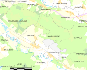
Saint-Clément
- commune in Meurthe-et-Moselle, France
- Country:
- Postal Code: 54950
- Coordinates: 48° 31' 53" N, 6° 36' 9" E
- GPS tracks (wikiloc): [Link]
- Area: 16.47 sq km
- Population: 852


Fréménil
- commune in Meurthe-et-Moselle, France
- Country:
- Postal Code: 54450
- Coordinates: 48° 33' 55" N, 6° 42' 46" E
- GPS tracks (wikiloc): [Link]
- Area: 3.04 sq km
- Population: 226


Buriville
- commune in Meurthe-et-Moselle, France
- Country:
- Postal Code: 54450
- Coordinates: 48° 32' 21" N, 6° 42' 29" E
- GPS tracks (wikiloc): [Link]
- Area: 11.44 sq km
- Population: 72


Manonviller
- commune in Meurthe-et-Moselle, France
- Country:
- Postal Code: 54300
- Coordinates: 48° 35' 0" N, 6° 39' 3" E
- GPS tracks (wikiloc): [Link]
- Area: 6.98 sq km
- Population: 171


Domjevin
- commune in Meurthe-et-Moselle, France
- Country:
- Postal Code: 54450
- Coordinates: 48° 34' 34" N, 6° 41' 48" E
- GPS tracks (wikiloc): [Link]
- Area: 10.28 sq km
- Population: 255