Barbas (Barbas)

- commune in Meurthe-et-Moselle, France
- Country:

- Postal Code: 54450
- Coordinates: 48° 34' 23" N, 6° 50' 49" E


- GPS tracks (wikiloc): [Link]
- Area: 7.33 sq km
- Population: 185
- Wikipedia en: wiki(en)
- Wikipedia: wiki(fr)
- Wikidata storage: Wikidata: Q858286
- Wikipedia Commons Category: [Link]
- Freebase ID: [/m/03qdf7c]
- GeoNames ID: Alt: [6449710]
- SIREN number: [215400441]
- BnF ID: [152641131]
- INSEE municipality code: 54044
Shares border with regions:


Halloville
- commune in Meurthe-et-Moselle, France
- Country:
- Postal Code: 54450
- Coordinates: 48° 33' 15" N, 6° 51' 40" E
- GPS tracks (wikiloc): [Link]
- Area: 3.93 sq km
- Population: 76


Harbouey
- commune in Meurthe-et-Moselle, France
- Country:
- Postal Code: 54450
- Coordinates: 48° 34' 12" N, 6° 53' 12" E
- GPS tracks (wikiloc): [Link]
- Area: 10.14 sq km
- Population: 115


Blâmont
- commune in Meurthe-et-Moselle, France
- Country:
- Postal Code: 54450
- Coordinates: 48° 35' 23" N, 6° 50' 32" E
- GPS tracks (wikiloc): [Link]
- Area: 7.41 sq km
- Population: 1091


Ancerviller
- commune in Meurthe-et-Moselle, France
- Country:
- Postal Code: 54450
- Coordinates: 48° 31' 56" N, 6° 50' 6" E
- GPS tracks (wikiloc): [Link]
- Area: 12.34 sq km
- Population: 273

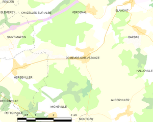
Domèvre-sur-Vezouze
- commune in Meurthe-et-Moselle, France
- Country:
- Postal Code: 54450
- Coordinates: 48° 33' 41" N, 6° 48' 22" E
- GPS tracks (wikiloc): [Link]
- Area: 14.78 sq km
- Population: 289