canton of Blâmont (canton de Blâmont)
- canton of France
- Country:

- Capital: Blâmont
- Coordinates: 48° 35' 26" N, 6° 46' 59" E


- GPS tracks (wikiloc): [Link]
- Wikidata storage: Wikidata: Q1669540
- INSEE canton code: [5406]
Includes regions:


Halloville
- commune in Meurthe-et-Moselle, France
- Country:
- Postal Code: 54450
- Coordinates: 48° 33' 15" N, 6° 51' 40" E
- GPS tracks (wikiloc): [Link]
- Area: 3.93 sq km
- Population: 76


Vaucourt
- commune in Meurthe-et-Moselle, France
- Country:
- Postal Code: 54370
- Coordinates: 48° 40' 10" N, 6° 41' 33" E
- GPS tracks (wikiloc): [Link]
- Area: 6.29 sq km
- Population: 69


Remoncourt
- commune in Meurthe-et-Moselle, France
- Country:
- Postal Code: 54370
- Coordinates: 48° 39' 33" N, 6° 44' 12" E
- GPS tracks (wikiloc): [Link]
- AboveSeaLevel: 250 м m
- Area: 6.68 sq km
- Population: 45


Vého
- commune in Meurthe-et-Moselle, France
- Country:
- Postal Code: 54450
- Coordinates: 48° 35' 48" N, 6° 42' 39" E
- GPS tracks (wikiloc): [Link]
- Area: 7.74 sq km
- Population: 97


Nonhigny
- commune in Meurthe-et-Moselle, France
- Country:
- Postal Code: 54450
- Coordinates: 48° 33' 2" N, 6° 52' 50" E
- GPS tracks (wikiloc): [Link]
- Area: 5.75 sq km
- Population: 131


Saint-Martin
- commune in Meurthe-et-Moselle, France
- Country:
- Postal Code: 54450
- Coordinates: 48° 34' 5" N, 6° 45' 10" E
- GPS tracks (wikiloc): [Link]
- AboveSeaLevel: 240 м m
- Area: 4.87 sq km
- Population: 61


Ogéviller
- commune in Meurthe-et-Moselle, France
- Country:
- Postal Code: 54450
- Coordinates: 48° 32' 49" N, 6° 43' 32" E
- GPS tracks (wikiloc): [Link]
- Area: 3.54 sq km
- Population: 287


Montreux
- commune in Meurthe-et-Moselle, France
- Country:
- Postal Code: 54450
- Coordinates: 48° 32' 9" N, 6° 52' 56" E
- GPS tracks (wikiloc): [Link]
- Area: 3.69 sq km
- Population: 63

Blémerey
- commune in Meurthe-et-Moselle, France
- Country:
- Postal Code: 54450
- Coordinates: 48° 34' 59" N, 6° 44' 4" E
- GPS tracks (wikiloc): [Link]
- AboveSeaLevel: 266 м m
- Area: 3.82 sq km
- Population: 67


Réclonville
- commune in Meurthe-et-Moselle, France
- Country:
- Postal Code: 54450
- Coordinates: 48° 32' 26" N, 6° 43' 41" E
- GPS tracks (wikiloc): [Link]
- Area: 2.96 sq km
- Population: 73


Xousse
- commune in Meurthe-et-Moselle, France
- Country:
- Postal Code: 54370
- Coordinates: 48° 39' 25" N, 6° 42' 35" E
- GPS tracks (wikiloc): [Link]
- Area: 6.13 sq km
- Population: 124


Herbéviller
- commune in Meurthe-et-Moselle, France
- Country:
- Postal Code: 54450
- Coordinates: 48° 33' 25" N, 6° 45' 13" E
- GPS tracks (wikiloc): [Link]
- Area: 8.12 sq km
- Population: 228


Emberménil
- commune in Meurthe-et-Moselle, France
- Country:
- Postal Code: 54370
- Coordinates: 48° 37' 45" N, 6° 41' 45" E
- GPS tracks (wikiloc): [Link]
- Area: 14.39 sq km
- Population: 263

Repaix
- commune in Meurthe-et-Moselle, France
- Country:
- Postal Code: 54450
- Coordinates: 48° 36' 28" N, 6° 49' 58" E
- GPS tracks (wikiloc): [Link]
- Area: 4.86 sq km
- Population: 90

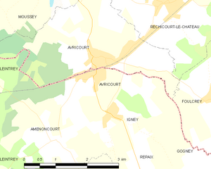
Avricourt
- commune in Meurthe-et-Moselle, France
- Country:
- Postal Code: 54450
- Coordinates: 48° 38' 41" N, 6° 48' 21" E
- GPS tracks (wikiloc): [Link]
- AboveSeaLevel: 310 м m
- Area: 2.25 sq km
- Population: 385


Harbouey
- commune in Meurthe-et-Moselle, France
- Country:
- Postal Code: 54450
- Coordinates: 48° 34' 12" N, 6° 53' 12" E
- GPS tracks (wikiloc): [Link]
- Area: 10.14 sq km
- Population: 115

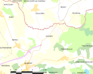
Gogney
- commune in Meurthe-et-Moselle, France
- Country:
- Postal Code: 54450
- Coordinates: 48° 36' 49" N, 6° 51' 31" E
- GPS tracks (wikiloc): [Link]
- Area: 8.8 sq km
- Population: 47

Autrepierre
- commune in Meurthe-et-Moselle, France
- Country:
- Postal Code: 54450
- Coordinates: 48° 36' 42" N, 6° 48' 4" E
- GPS tracks (wikiloc): [Link]
- Area: 7.75 sq km
- Population: 81


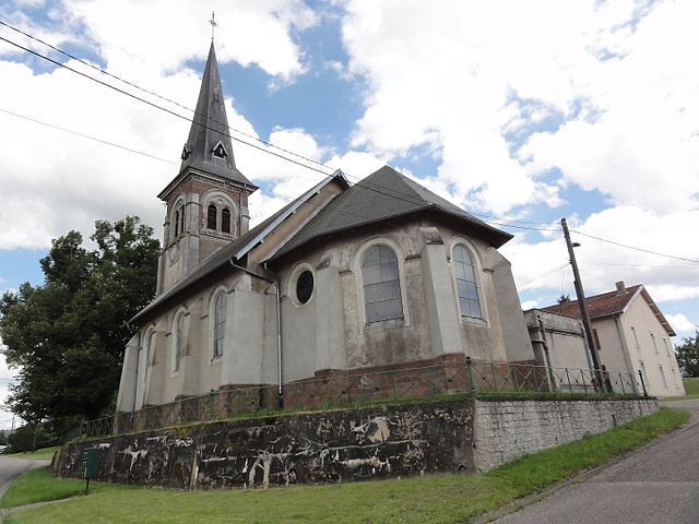
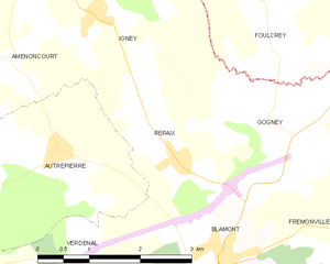
Verdenal
- commune in Meurthe-et-Moselle, France
- Country:
- Postal Code: 54450
- Coordinates: 48° 35' 1" N, 6° 48' 40" E
- GPS tracks (wikiloc): [Link]
- Area: 6.54 sq km
- Population: 154


Leintrey
- commune in Meurthe-et-Moselle, France
- Country:
- Postal Code: 54450
- Coordinates: 48° 37' 25" N, 6° 44' 16" E
- GPS tracks (wikiloc): [Link]
- Area: 15.44 sq km
- Population: 136


Fréménil
- commune in Meurthe-et-Moselle, France
- Country:
- Postal Code: 54450
- Coordinates: 48° 33' 55" N, 6° 42' 46" E
- GPS tracks (wikiloc): [Link]
- Area: 3.04 sq km
- Population: 226


Chazelles-sur-Albe
- commune in Meurthe-et-Moselle, France
- Country:
- Postal Code: 54450
- Coordinates: 48° 35' 23" N, 6° 46' 45" E
- GPS tracks (wikiloc): [Link]
- Area: 3.39 sq km
- Population: 38


Buriville
- commune in Meurthe-et-Moselle, France
- Country:
- Postal Code: 54450
- Coordinates: 48° 32' 21" N, 6° 42' 29" E
- GPS tracks (wikiloc): [Link]
- Area: 11.44 sq km
- Population: 72

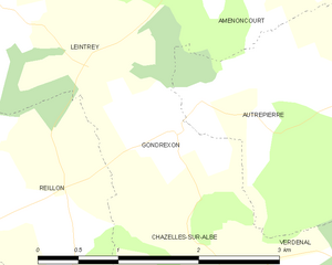
Gondrexon
- commune in Meurthe-et-Moselle, France
- Country:
- Postal Code: 54450
- Coordinates: 48° 36' 20" N, 6° 46' 11" E
- GPS tracks (wikiloc): [Link]
- Area: 2.49 sq km
- Population: 38


Reillon
- commune in Meurthe-et-Moselle, France
- Country:
- Postal Code: 54450
- Coordinates: 48° 35' 54" N, 6° 44' 36" E
- GPS tracks (wikiloc): [Link]
- AboveSeaLevel: 269 м m
- Area: 4.39 sq km
- Population: 78


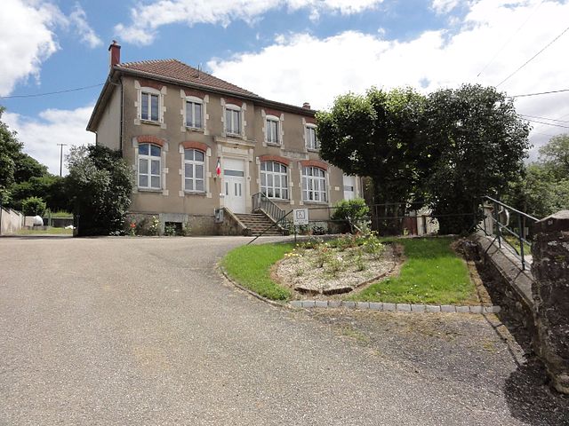
Blâmont
- commune in Meurthe-et-Moselle, France
- Country:
- Postal Code: 54450
- Coordinates: 48° 35' 23" N, 6° 50' 32" E
- GPS tracks (wikiloc): [Link]
- Area: 7.41 sq km
- Population: 1091


Frémonville
- commune in Meurthe-et-Moselle, France
- Country:
- Postal Code: 54450
- Coordinates: 48° 35' 43" N, 6° 53' 13" E
- GPS tracks (wikiloc): [Link]
- Area: 13.65 sq km
- Population: 182


Amenoncourt
- commune in Meurthe-et-Moselle, France
- Country:
- Postal Code: 54450
- Coordinates: 48° 37' 40" N, 6° 47' 20" E
- GPS tracks (wikiloc): [Link]
- Area: 7.23 sq km
- Population: 82

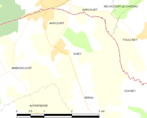
Igney
- commune in Meurthe-et-Moselle, France
- Country:
- Postal Code: 54450
- Coordinates: 48° 38' 2" N, 6° 48' 50" E
- GPS tracks (wikiloc): [Link]
- AboveSeaLevel: 350 м m
- Area: 4.71 sq km
- Population: 128

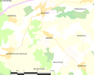
Barbas
- commune in Meurthe-et-Moselle, France
- Country:
- Postal Code: 54450
- Coordinates: 48° 34' 23" N, 6° 50' 49" E
- GPS tracks (wikiloc): [Link]
- Area: 7.33 sq km
- Population: 185


Ancerviller
- commune in Meurthe-et-Moselle, France
- Country:
- Postal Code: 54450
- Coordinates: 48° 31' 56" N, 6° 50' 6" E
- GPS tracks (wikiloc): [Link]
- Area: 12.34 sq km
- Population: 273

Domèvre-sur-Vezouze
- commune in Meurthe-et-Moselle, France
- Country:
- Postal Code: 54450
- Coordinates: 48° 33' 41" N, 6° 48' 22" E
- GPS tracks (wikiloc): [Link]
- Area: 14.78 sq km
- Population: 289