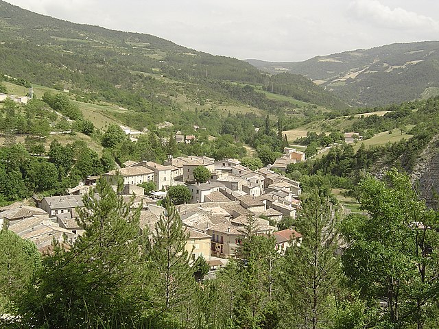
Brette (Brette)

- commune in Drôme, France
 Hiking in Brette
Hiking in Brette, which is part of the beautiful French region of Auvergne-Rhône-Alpes, offers stunning landscapes, diverse trails, and opportunities to experience nature at its finest. Here’s an overview of what you can expect:
Trails
Brette features various hiking trails suitable for different skill levels, from beginners to experienced hikers. Many trails are well-marked, making navigation easier. You can find routes that take you through forests, along rivers, and up into the hills, offering diverse landscapes.
Highlights
- Scenic Views: The area boasts breathtaking views of the surrounding mountains, valleys, and sometimes even distant peaks, especially in the Monts du Forez region.
- Flora and Fauna: Hikers can encounter a wide variety of plant and animal life. Spring and summer bring wildflowers, and you might spot deer or various bird species along the way.
- Cultural Sites: Some trails lead to historical sites, old chapels, and ruins, adding a cultural element to your hiking experience.
Preparation
- Weather: Check the weather forecast before you go, as conditions can change quickly in mountainous regions. Dress in layers and pack waterproof clothing if necessary.
- Safety: Always carry enough water, snacks, and a first-aid kit. It's also advisable to bring a map or a GPS device.
- Footwear: Ensure you have suitable hiking boots with good tread for varying terrain.
Best Time to Hike
The ideal hiking seasons are spring (April to June) and fall (September to October), when the weather is usually mild, and the landscapes are particularly beautiful.
Resources
Local tourist offices or hiking clubs can provide maps, guides, and additional information about trails. There may also be organized hikes available for those who prefer a structured experience.
By preparing thoughtfully, you can ensure a fantastic hiking experience in Brette, connecting with nature and enjoying the beautiful surroundings.
- Country:

- Postal Code: 26340
- Coordinates: 44° 35' 16" N, 5° 18' 39" E


- GPS tracks (wikiloc): [Link]
- Area: 15.5 sq km
- Population: 39
- Wikipedia en: wiki(en)
- Wikipedia: wiki(fr)
- Wikidata storage: Wikidata: Q476007
- Wikipedia Commons Category: [Link]
- Freebase ID: [/m/03h3qbm]
- GeoNames ID: Alt: [6447900]
- SIREN number: [212600621]
- BnF ID: [15252923v]
- INSEE municipality code: 26062
Shares border with regions:

Saint-Nazaire-le-Désert
- commune in Drôme, France
Hiking in Saint-Nazaire-le-Désert
Saint-Nazaire-le-Désert is a charming commune located in the Drôme department in southeastern France. It offers a unique blend of natural beauty, historical significance, and outdoor activities, making it a great destination for hiking enthusiasts....
- Country:
- Postal Code: 26340
- Coordinates: 44° 34' 12" N, 5° 16' 33" E
- GPS tracks (wikiloc): [Link]
- Area: 46.62 sq km
- Population: 174
Volvent
- commune in Drôme, France
Hiking in Volvent
It seems there might be a bit of confusion; there isn't a widely recognized hiking destination called "Volvent." However, if you meant "Vallentuna" (located in Sweden) or perhaps "volcanic" regions like those in Iceland, or if you're referring to a different location with a similar name, please clarify....
- Country:
- Postal Code: 26470
- Coordinates: 44° 33' 36" N, 5° 20' 40" E
- GPS tracks (wikiloc): [Link]
- Area: 16.73 sq km
- Population: 35
Pradelle
- commune in Drôme, France
Hiking in Pradelle
Pradelle, located in the Drôme department in southeastern France, offers a delightful setting for hiking enthusiasts. Nestled in the beautiful landscape of the Drôme Provençale region, it boasts picturesque views, rolling hills, and diverse flora and fauna....
- Country:
- Postal Code: 26340
- Coordinates: 44° 36' 29" N, 5° 17' 31" E
- GPS tracks (wikiloc): [Link]
- Area: 12.92 sq km
- Population: 19


Aucelon
- commune in Drôme, France
Hiking in Aucelon
Aucelon is a small village located in the Ardèche region of France, known for its stunning natural beauty and diverse hiking opportunities. Here’s an overview of what to expect when hiking in Aucelon:...
- Country:
- Postal Code: 26340
- Coordinates: 44° 37' 27" N, 5° 20' 40" E
- GPS tracks (wikiloc): [Link]
- Area: 26.34 sq km
- Population: 14