canton of Richelieu (canton de Richelieu)
- Township in Indre-et-Loire, France
- Country:

- Capital: Richelieu
- Coordinates: 47° 1' 27" N, 0° 22' 23" E


- GPS tracks (wikiloc): [Link]
- Wikidata storage: Wikidata: Q1151256
- INSEE canton code: [3719]
Includes regions:


Chaveignes
- commune in Indre-et-Loire, France
- Country:
- Postal Code: 37120
- Coordinates: 47° 2' 16" N, 0° 20' 59" E
- GPS tracks (wikiloc): [Link]
- Area: 21.34 sq km
- Population: 554
- Web site: [Link]


Courcoué
- commune in Indre-et-Loire, France
- Country:
- Postal Code: 37120
- Coordinates: 47° 2' 2" N, 0° 23' 45" E
- GPS tracks (wikiloc): [Link]
- Area: 15.66 sq km
- Population: 266


Champigny-sur-Veude
- commune in Indre-et-Loire, France
- Country:
- Postal Code: 37120
- Coordinates: 47° 4' 1" N, 0° 19' 19" E
- GPS tracks (wikiloc): [Link]
- Area: 16.18 sq km
- Population: 875
- Web site: [Link]


Braye-sous-Faye
- commune in Indre-et-Loire, France
- Country:
- Postal Code: 37120
- Coordinates: 46° 59' 29" N, 0° 20' 48" E
- GPS tracks (wikiloc): [Link]
- Area: 15.67 sq km
- Population: 339


La Tour-Saint-Gelin
- commune in Indre-et-Loire, France
- Country:
- Postal Code: 37120
- Coordinates: 47° 2' 59" N, 0° 24' 9" E
- GPS tracks (wikiloc): [Link]
- Area: 13.45 sq km
- Population: 534
- Web site: [Link]

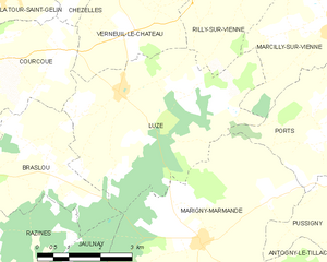
Luzé
- commune in Indre-et-Loire, France
- Country:
- Postal Code: 37120
- Coordinates: 47° 1' 24" N, 0° 27' 9" E
- GPS tracks (wikiloc): [Link]
- Area: 20.3 sq km
- Population: 261


Ligré
- commune in Indre-et-Loire, France
- Country:
- Postal Code: 37500
- Coordinates: 47° 6' 44" N, 0° 16' 31" E
- GPS tracks (wikiloc): [Link]
- Area: 27.7 sq km
- Population: 1072


Lémeré
- commune in Indre-et-Loire, France
- Country:
- Postal Code: 37120
- Coordinates: 47° 4' 58" N, 0° 20' 6" E
- GPS tracks (wikiloc): [Link]
- Area: 19.83 sq km
- Population: 503
- Web site: [Link]


Assay
- commune in Indre-et-Loire, France
- Country:
- Postal Code: 37120
- Coordinates: 47° 4' 28" N, 0° 17' 24" E
- GPS tracks (wikiloc): [Link]
- Area: 14.53 sq km
- Population: 159


Verneuil-le-Château
- commune in Indre-et-Loire, France
- Country:
- Postal Code: 37120
- Coordinates: 47° 2' 19" N, 0° 27' 27" E
- GPS tracks (wikiloc): [Link]
- Area: 8.44 sq km
- Population: 129


Jaulnay
- commune in Indre-et-Loire, France
- Country:
- Postal Code: 37120
- Coordinates: 46° 56' 54" N, 0° 24' 51" E
- GPS tracks (wikiloc): [Link]
- Area: 14.76 sq km
- Population: 257


Richelieu
- commune in Indre-et-Loire, France
- Country:
- Postal Code: 37120
- Coordinates: 47° 0' 51" N, 0° 19' 25" E
- GPS tracks (wikiloc): [Link]
- Area: 5.09 sq km
- Population: 1787
- Web site: [Link]


Braslou
- commune in Indre-et-Loire, France
- Country:
- Postal Code: 37120
- Coordinates: 47° 0' 0" N, 0° 23' 32" E
- GPS tracks (wikiloc): [Link]
- Area: 15.79 sq km
- Population: 308
- Web site: [Link]
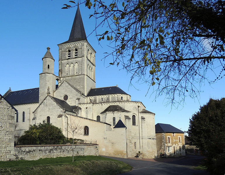
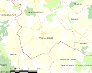
Faye-la-Vineuse
- commune in Indre-et-Loire, France
- Country:
- Postal Code: 37120
- Coordinates: 46° 57' 25" N, 0° 20' 25" E
- GPS tracks (wikiloc): [Link]
- Area: 17.55 sq km
- Population: 265

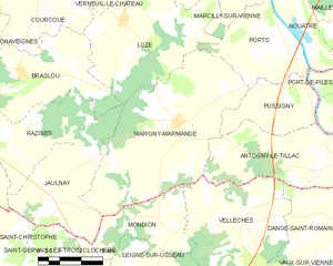
Marigny-Marmande
- commune in Indre-et-Loire, France
- Country:
- Postal Code: 37120
- Coordinates: 46° 58' 51" N, 0° 29' 21" E
- GPS tracks (wikiloc): [Link]
- Area: 30.83 sq km
- Population: 581
- Web site: [Link]


Razines
- commune in Indre-et-Loire, France
- Country:
- Postal Code: 37120
- Coordinates: 46° 58' 32" N, 0° 22' 40" E
- GPS tracks (wikiloc): [Link]
- Area: 14.73 sq km
- Population: 239