canton of Soultz-sous-Forêts (canton de Soultz-sous-Forêts)

- canton of France (until March 2015)
- Country:

- Capital: Soultz-sous-Forêts
- Coordinates: 48° 56' 16" N, 7° 53' 3" E


- GPS tracks (wikiloc): [Link]
- Wikidata storage: Wikidata: Q1398541
Includes regions:


Aschbach
- commune in Bas-Rhin, France
- Country:
- Postal Code: 67250
- Coordinates: 48° 56' 4" N, 7° 59' 0" E
- GPS tracks (wikiloc): [Link]
- Area: 4.32 sq km
- Population: 701


Drachenbronn-Birlenbach
- commune in Bas-Rhin, France
- Country:
- Postal Code: 67160
- Coordinates: 48° 59' 11" N, 7° 52' 13" E
- GPS tracks (wikiloc): [Link]
- Area: 7.13 sq km
- Population: 836
- Web site: [Link]


Keffenach
- commune in Bas-Rhin, France
- Country:
- Postal Code: 67250
- Coordinates: 48° 57' 53" N, 7° 52' 56" E
- GPS tracks (wikiloc): [Link]
- Area: 2.39 sq km
- Population: 189
Memmelshoffen
- commune in Bas-Rhin, France
- Country:
- Postal Code: 67250
- Coordinates: 48° 57' 37" N, 7° 52' 11" E
- GPS tracks (wikiloc): [Link]
- Area: 1.82 sq km
- Population: 332


Rittershoffen
- commune in Bas-Rhin, France
- Country:
- Postal Code: 67690
- Coordinates: 48° 54' 13" N, 7° 57' 5" E
- GPS tracks (wikiloc): [Link]
- Area: 12.13 sq km
- Population: 910

Merkwiller-Pechelbronn
- commune in Bas-Rhin, France
- Country:
- Postal Code: 67250
- Coordinates: 48° 56' 21" N, 7° 49' 32" E
- GPS tracks (wikiloc): [Link]
- Area: 3.76 sq km
- Population: 919
- Web site: [Link]

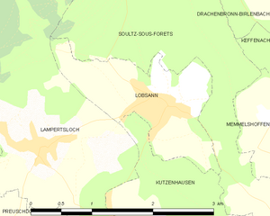
Lobsann
- commune in Bas-Rhin, France
- Country:
- Postal Code: 67250
- Coordinates: 48° 57' 48" N, 7° 50' 46" E
- GPS tracks (wikiloc): [Link]
- Area: 2.73 sq km
- Population: 634
Retschwiller
- commune in Bas-Rhin, France
- Country:
- Postal Code: 67250
- Coordinates: 48° 57' 0" N, 7° 52' 45" E
- GPS tracks (wikiloc): [Link]
- Area: 3.26 sq km
- Population: 279


Stundwiller
- commune in Bas-Rhin, France
- Country:
- Postal Code: 67250
- Coordinates: 48° 55' 32" N, 7° 59' 26" E
- GPS tracks (wikiloc): [Link]
- Area: 3.32 sq km
- Population: 477


Surbourg
- commune in Bas-Rhin, France
- Country:
- Postal Code: 67250
- Coordinates: 48° 54' 32" N, 7° 50' 52" E
- GPS tracks (wikiloc): [Link]
- Area: 10.46 sq km
- Population: 1667

Hatten
- commune in Bas-Rhin, France
- Country:
- Postal Code: 67690
- Coordinates: 48° 54' 7" N, 7° 58' 44" E
- GPS tracks (wikiloc): [Link]
- Area: 18.91 sq km
- Population: 1925

Schœnenbourg
- commune in Bas-Rhin, France
- Country:
- Postal Code: 67250
- Coordinates: 48° 57' 6" N, 7° 54' 47" E
- GPS tracks (wikiloc): [Link]
- Area: 5.47 sq km
- Population: 687


Oberrœdern
- commune in Bas-Rhin, France
- Country:
- Postal Code: 67250
- Coordinates: 48° 55' 18" N, 7° 58' 27" E
- GPS tracks (wikiloc): [Link]
- Area: 5 sq km
- Population: 536


Betschdorf
- commune in Bas-Rhin, France
- Country:
- Postal Code: 67660
- Coordinates: 48° 53' 55" N, 7° 54' 21" E
- GPS tracks (wikiloc): [Link]
- Area: 28.11 sq km
- Population: 4113
- Web site: [Link]

Ingolsheim
- commune in Bas-Rhin, France
- Country:
- Postal Code: 67250
- Coordinates: 48° 58' 27" N, 7° 56' 13" E
- GPS tracks (wikiloc): [Link]
- Area: 4.46 sq km
- Population: 294
- Web site: [Link]


Kutzenhausen
- commune in Bas-Rhin, France
- Country:
- Postal Code: 67250
- Coordinates: 48° 55' 59" N, 7° 51' 20" E
- GPS tracks (wikiloc): [Link]
- Area: 7.2 sq km
- Population: 923


Hoffen
- commune in Bas-Rhin, France
- Country:
- Postal Code: 67250
- Coordinates: 48° 55' 47" N, 7° 56' 32" E
- GPS tracks (wikiloc): [Link]
- Area: 9.45 sq km
- Population: 1138


Hunspach
- commune in Bas-Rhin, France
- Country:
- Postal Code: 67250
- Local Dialing Code: 388
- Coordinates: 48° 57' 11" N, 7° 56' 32" E
- GPS tracks (wikiloc): [Link]
- Area: 5.49 sq km
- Population: 637


Soultz-sous-Forêts
- commune in Bas-Rhin, France
- Country:
- Postal Code: 67250
- Coordinates: 48° 56' 19" N, 7° 52' 50" E
- GPS tracks (wikiloc): [Link]
- Area: 15.15 sq km
- Population: 3127
- Web site: [Link]