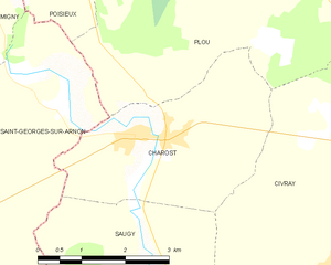
canton of Chârost (canton de Chârost)

- canton of France
- Country:

- Capital: Chârost
- Coordinates: 46° 59' 37" N, 2° 7' 1" E


- GPS tracks (wikiloc): [Link]
- Population: 14313
- Wikipedia en: wiki(en)
- Wikipedia: wiki(fr)
- Wikidata storage: Wikidata: Q1657686
- Freebase ID: [/m/05sz1nx]
- INSEE canton code: [1807]
Includes regions:
Saugy
- commune in Cher, France
- Country:
- Postal Code: 18290
- Coordinates: 46° 58' 13" N, 2° 7' 1" E
- GPS tracks (wikiloc): [Link]
- Area: 9.63 sq km
- Population: 80


Saint-Ambroix
- commune in Cher, France
- Country:
- Postal Code: 18290
- Coordinates: 46° 55' 54" N, 2° 7' 13" E
- GPS tracks (wikiloc): [Link]
- Area: 31.22 sq km
- Population: 374


Saint-Florent-sur-Cher
- commune in Cher, France
- Country:
- Postal Code: 18400
- Coordinates: 46° 59' 44" N, 2° 15' 6" E
- GPS tracks (wikiloc): [Link]
- Area: 22.41 sq km
- Population: 6671


Mareuil-sur-Arnon
- commune in Cher, France
- Country:
- Postal Code: 18290
- Coordinates: 46° 52' 52" N, 2° 9' 33" E
- GPS tracks (wikiloc): [Link]
- Area: 25.89 sq km
- Population: 545

Poisieux
- commune in Cher, France
- Country:
- Postal Code: 18290
- Coordinates: 47° 1' 45" N, 2° 5' 53" E
- GPS tracks (wikiloc): [Link]
- AboveSeaLevel: 145 м m
- Area: 10.3 sq km
- Population: 221


Lunery
- commune in Cher, France
- Country:
- Postal Code: 18400
- Coordinates: 46° 56' 7" N, 2° 16' 16" E
- GPS tracks (wikiloc): [Link]
- Area: 32.87 sq km
- Population: 1512
Morthomiers
- commune in Cher, France
- Country:
- Postal Code: 18570
- Coordinates: 47° 2' 13" N, 2° 16' 36" E
- GPS tracks (wikiloc): [Link]
- Area: 14.54 sq km
- Population: 758
- Web site: [Link]

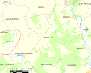
Primelles
- commune in Cher, France
- Country:
- Postal Code: 18400
- Coordinates: 46° 55' 42" N, 2° 12' 47" E
- GPS tracks (wikiloc): [Link]
- Area: 26.57 sq km
- Population: 250


Civray
- commune in Cher, France
- Country:
- Postal Code: 18290
- Coordinates: 46° 58' 2" N, 2° 10' 28" E
- GPS tracks (wikiloc): [Link]
- Area: 40.87 sq km
- Population: 979


Plou
- commune in Cher, France
- Country:
- Postal Code: 18290
- Coordinates: 47° 0' 52" N, 2° 9' 17" E
- GPS tracks (wikiloc): [Link]
- Area: 33.21 sq km
- Population: 528


Le Subdray
- commune in Cher, France
- Country:
- Postal Code: 18570
- Coordinates: 47° 0' 39" N, 2° 17' 40" E
- GPS tracks (wikiloc): [Link]
- Area: 20.28 sq km
- Population: 945

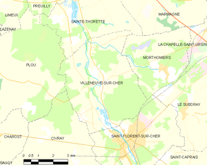
Villeneuve-sur-Cher
- commune in Cher, France
- Country:
- Postal Code: 18400
- Coordinates: 47° 1' 44" N, 2° 13' 23" E
- GPS tracks (wikiloc): [Link]
- Area: 26.13 sq km
- Population: 465

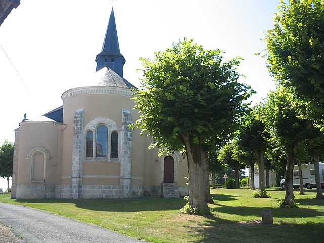
Chârost
- commune in Cher, France
- Country:
- Postal Code: 18290
- Coordinates: 46° 59' 34" N, 2° 6' 58" E
- GPS tracks (wikiloc): [Link]
- Area: 10.97 sq km
- Population: 985
- Web site: [Link]