Saint-Ambroix (Saint-Ambroix)

- commune in Cher, France
- Country:

- Postal Code: 18290
- Coordinates: 46° 55' 54" N, 2° 7' 13" E


- GPS tracks (wikiloc): [Link]
- Area: 31.22 sq km
- Population: 374
- Wikipedia en: wiki(en)
- Wikipedia: wiki(fr)
- Wikidata storage: Wikidata: Q1172283
- Wikipedia Commons Category: [Link]
- Freebase ID: [/m/03md1qp]
- GeoNames ID: Alt: [6428261]
- SIREN number: [211801980]
- BnF ID: [152495446]
- VIAF ID: Alt: [235705297]
- INSEE municipality code: 18198
Shares border with regions:
Chouday
- commune in Indre, France
- Country:
- Postal Code: 36100
- Coordinates: 46° 54' 38" N, 2° 3' 54" E
- GPS tracks (wikiloc): [Link]
- Area: 30 sq km
- Population: 148


Ségry
- commune in Indre, France
- Country:
- Postal Code: 36100
- Coordinates: 46° 53' 26" N, 2° 4' 57" E
- GPS tracks (wikiloc): [Link]
- Area: 33.06 sq km
- Population: 526
Saugy
- commune in Cher, France
- Country:
- Postal Code: 18290
- Coordinates: 46° 58' 13" N, 2° 7' 1" E
- GPS tracks (wikiloc): [Link]
- Area: 9.63 sq km
- Population: 80


Mareuil-sur-Arnon
- commune in Cher, France
- Country:
- Postal Code: 18290
- Coordinates: 46° 52' 52" N, 2° 9' 33" E
- GPS tracks (wikiloc): [Link]
- Area: 25.89 sq km
- Population: 545

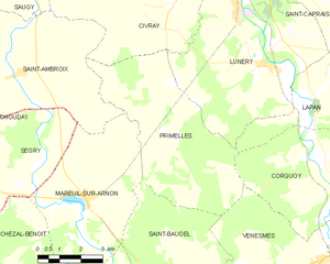
Primelles
- commune in Cher, France
- Country:
- Postal Code: 18400
- Coordinates: 46° 55' 42" N, 2° 12' 47" E
- GPS tracks (wikiloc): [Link]
- Area: 26.57 sq km
- Population: 250


Civray
- commune in Cher, France
- Country:
- Postal Code: 18290
- Coordinates: 46° 58' 2" N, 2° 10' 28" E
- GPS tracks (wikiloc): [Link]
- Area: 40.87 sq km
- Population: 979

Issoudun
- commune in Indre, France
- Country:
- Postal Code: 36100
- Coordinates: 46° 56' 53" N, 1° 59' 36" E
- GPS tracks (wikiloc): [Link]
- AboveSeaLevel: 129 м m
- Area: 36.6 sq km
- Population: 12029
- Web site: [Link]