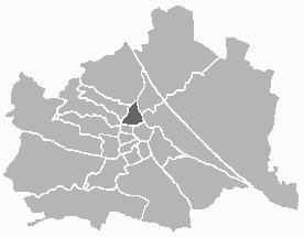
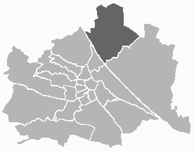
Döbling (Döbling)

- 19. district of Vienna
 Hiking in Döbling
Döbling is a charming district in Vienna, Austria, known for its scenic landscapes, vineyards, and proximity to the Vienna Woods (Wienerwald). Here are some highlights and tips for hiking in Döbling:
Hiking Trails:
-
Kahlenberg: One of the most popular hiking destinations near Döbling, Kahlenberg offers stunning panoramic views of Vienna. The trail to the summit is well-marked and can be accessed from various points in the district.
-
Nussberg: This hill is part of the Vienna Woods and provides relatively easy hiking trails. It’s an excellent spot for families and those new to hiking. The trails here lead through lovely vineyards and offer beautiful views of the city.
-
Grinzing to Kahlenberg: This trail takes you from the quaint village of Grinzing, known for its wine taverns, up to Kahlenberg. It’s a moderate hike, and you can enjoy the local wine culture along the way.
-
Wine Trail (Weinwanderweg): Döbling is famous for its vineyards, and the wine hiking trails allow you to explore this unique landscape. The routes often connect various vineyards, and you'll have opportunities for wine tasting during or after your hike.
Tips for Hiking in Döbling:
-
Best Time to Hike: Late spring and early autumn offer pleasant weather and beautiful scenery. The fall is particularly stunning due to the changing colors of the leaves in the Vienna Woods.
-
Stay Hydrated: Bring plenty of water, especially during warmer months, as some trails may not have facilities nearby.
-
Explore Vineyards: Consider stopping at a heuriger (wine tavern) after your hike to enjoy local wine and regional dishes.
-
Navigation: While many trails are well marked, having a map or a hiking app can help you navigate more effectively.
-
Safety: Always inform someone about your hiking plans and expected return time. Stick to marked trails, especially if you're not familiar with the area.
Getting There:
Döbling is well-connected by public transportation, including trams and buses. The U-Bahn (subway) also serves as a gateway to some nearby hiking trails.
Hiking in Döbling allows you to experience the natural beauty and cultural richness of the area. Enjoy your hike and the stunning views of Vienna!
- Country:

- Postal Code: 1190
- Licence Plate Code: W
- Coordinates: 48° 15' 59" N, 16° 19' 22" E


- GPS tracks (wikiloc): [Link]
- AboveSeaLevel: 247 м m
- Area: 24.9 sq km
- Web site: http://www.wien.gv.at/bezirke/doebling/
- Wikipedia en: wiki(en)
- Wikipedia: wiki(de)
- Wikidata storage: Wikidata: Q267360
- Wikipedia Commons Gallery: [Link]
- Wikipedia Commons Category: [Link]
- Freebase ID: [/m/06mrtf]
- GeoNames ID: Alt: [2780893]
- VIAF ID: Alt: [125494805]
- GND ID: Alt: [4079284-5]
- archINFORM location ID: [3699]
- Library of Congress authority ID: Alt: [n81003412]
- MusicBrainz area ID: [a2472c33-a972-493e-89a7-1947fc9b65ce]
- TGN ID: [1004334]
- Austrian municipality key: [91901]
Shares border with regions:

Alsergrund
- 9. district of Vienna
Hiking in Alsergrund
Alsergrund is one of the 23 districts of Vienna, Austria, and while it's not primarily known for hiking in the traditional sense of wilderness trails, it does offer some enjoyable walking opportunities, particularly for urban hiking or strolling through green spaces....
- Country:
- Postal Code: 1090
- Licence Plate Code: W
- Coordinates: 48° 13' 31" N, 16° 21' 25" E
- GPS tracks (wikiloc): [Link]
- AboveSeaLevel: 179 м m
- Area: 2.99 sq km
- Web site: [Link]
Hernals
- 17. district of Vienna
Hiking in Hernals
Hernals is a district in Vienna, Austria, known for its charming neighborhoods and proximity to nature. While Hernals itself is primarily urban, the nearby areas, especially the Vienna Woods (Wienerwald), offer excellent hiking opportunities....
- Country:
- Postal Code: 1170
- Licence Plate Code: W
- Coordinates: 48° 13' 57" N, 16° 16' 46" E
- GPS tracks (wikiloc): [Link]
- AboveSeaLevel: 224 м m
- Area: 11.35 sq km
- Web site: [Link]

Floridsdorf
- 21. district of Vienna
Hiking in Floridsdorf
Floridsdorf is one of the 23 districts of Vienna, Austria, and while it is primarily an urban area, there are some lovely opportunities for outdoor activities and hiking in and around the district. Here are some highlights for hiking enthusiasts:...
- Country:
- Postal Code: 1210
- Licence Plate Code: W
- Coordinates: 48° 17' 0" N, 16° 24' 44" E
- GPS tracks (wikiloc): [Link]
- AboveSeaLevel: 159 м m
- Area: 44.52 sq km
- Web site: [Link]
Brigittenau
- 20. district of Vienna
Hiking in Brigittenau
Brigittenau is a 20th district of Vienna, Austria, situated on the northern banks of the Danube Canal. While it is an urban area and not traditionally associated with hiking, it still offers some opportunities for walking and enjoying the outdoors. Here are some aspects to consider if you’re interested in hiking or walking in and around Brigittenau:...
- Country:
- Postal Code: 1200
- Licence Plate Code: W
- Coordinates: 48° 14' 12" N, 16° 22' 10" E
- GPS tracks (wikiloc): [Link]
- AboveSeaLevel: 165 м m
- Area: 5.67 sq km
- Web site: [Link]

Lower Austria
- federated state of Austria
Hiking in Lower Austria
Lower Austria, known as Niederösterreich in German, is a fantastic destination for hiking enthusiasts. The region is characterized by its diverse landscapes, including rolling hills, vineyards, forests, and the scenic Danube River. Here are some highlights and popular hiking areas in Lower Austria:...
- Country:
- Capital: St. Pölten
- Coordinates: 48° 20' 0" N, 15° 45' 0" E
- GPS tracks (wikiloc): [Link]
- AboveSeaLevel: 279 м m
- Area: 19186.0 sq km
- Population: 1653419
- Web site: [Link]

Klosterneuburg
- town in Lower Austria
Hiking in Klosterneuburg
Klosterneuburg, located just north of Vienna, Austria, offers a variety of beautiful hiking trails that cater to different skill levels and preferences. The region is characterized by its picturesque landscapes, historical sites, and proximity to the Vienna Woods (Wienerwald). Here are some highlights and tips for hiking in Klosterneuburg:...
- Country:
- Local Dialing Code: 02243
- Licence Plate Code: WU
- Coordinates: 48° 18' 15" N, 16° 19' 0" E
- GPS tracks (wikiloc): [Link]
- AboveSeaLevel: 192 м m
- Area: 76.2 sq km
- Population: 27058
Währing
- 18th district of Vienna
Hiking in Währing
Währing is a district in Vienna, Austria, known for its beautiful parks and hills, making it a delightful destination for hiking enthusiasts. Here are some highlights and tips for hiking in Währing:...
- Country:
- Postal Code: 1180
- Licence Plate Code: W
- Coordinates: 48° 13' 59" N, 16° 18' 53" E
- GPS tracks (wikiloc): [Link]
- AboveSeaLevel: 247 м m
- Area: 6.28 sq km
- Web site: [Link]