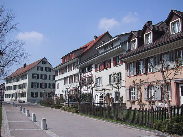
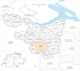
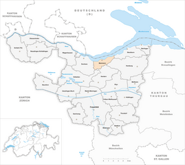
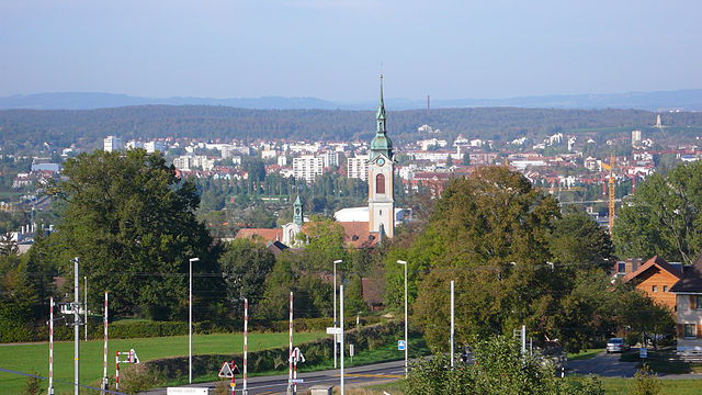
Frauenfeld District (Bezirk Frauenfeld)

- district of the canton of Thurgau, Switzerland
 Hiking in Frauenfeld District
Frauenfeld District, located in the canton of Thurgau in Switzerland, offers a beautiful array of hiking opportunities that cater to various skill levels. The region is characterized by its gentle hills, lush green landscapes, and picturesque views, making it an excellent choice for both experienced hikers and those new to the activity.
Popular Hiking Routes:
-
Bergwanderwege (Mountain Hiking Trails):
- These trails often lead up to local summits, providing stunning panoramic views of the surrounding countryside and, on clear days, even the Alps. Trails like the path to the nearby Hohentwiel offer unique scenery and cultural points of interest.
-
Aare River Trail:
- Following the Aare River, this trail features a blend of natural beauty and tranquility. It's great for leisurely walks, complete with opportunities for birdwatching and enjoying the gentle sounds of the flowing river.
-
Nature Trails:
- The district is dotted with several well-marked nature trails that can enhance your understanding of the local flora and fauna. Information panels placed along the trails provide insights into the ecosystem.
-
Wine Trails:
- Given the vineyard landscape of the region, you can find hiking paths that lead through the vineyards, offering a taste of the local wine culture along with great views. These routes can often be paired with wine tastings.
Key Highlights:
-
Historical Sites: Many hiking routes lead to historical landmarks and charming villages, where you can explore local culture, architecture, and history.
-
Accessibility: The trails are generally accessible, with good signage and facilities along the way—making them suitable for family hikes or group outings.
-
Seasonal Appeal: Each season brings its own charm. In spring and summer, enjoy the blooming wildflowers; autumn flaunts beautiful foliage, while winter hikes can offer a peaceful, snowy landscape.
Tips for Hiking in Frauenfeld District:
-
Trail Maps: Always carry a map or have a GPS device handy, as familiarity with the trails can enhance your experience.
-
Hydration and Nutrition: Bring plenty of water and snacks, especially on longer hikes.
-
Dress Appropriately: Layered clothing is advisable, as temperatures can change throughout the day.
-
Respect Nature: Follow the Leave No Trace principles to help protect the beautiful environment you’ll be exploring.
Conclusion:
Frauenfeld District is a hidden gem for hiking enthusiasts of all levels, offering trails that blend natural beauty with cultural experiences. Whether you're looking for a challenging hike or a peaceful nature stroll, this district has something to offer. Always check local weather conditions and trail statuses before heading out, and enjoy your time exploring this picturesque region!
- Country:

- Capital: Frauenfeld
- Licence Plate Code: TG
- Coordinates: 47° 33' 0" N, 8° 53' 0" E


- GPS tracks (wikiloc): [Link]
- AboveSeaLevel: 652 м m
- Area: 279.6 sq km
- Wikipedia en: wiki(en)
- Wikipedia: wiki(de)
- Wikidata storage: Wikidata: Q660546
- Wikipedia Commons Category: [Link]
- Freebase ID: [/m/0g3wnr]
- GeoNames ID: Alt: [8260143]
- archINFORM location ID: [5894]
Includes regions:


Felben-Wellhausen
- municipality in Switzerland
Hiking in Felben-Wellhausen
Felben-Wellhausen is a charming municipality located in the canton of Thurgau in Switzerland. While it's a small area, it offers a serene environment for hiking enthusiasts who wish to explore the scenic landscapes of the region. Here are some highlights for anyone looking to hike in and around Felben-Wellhausen:...
- Country:
- Postal Code: 8552
- Local Dialing Code: 052
- Licence Plate Code: TG
- Coordinates: 47° 34' 37" N, 8° 56' 34" E
- GPS tracks (wikiloc): [Link]
- AboveSeaLevel: 395 м m
- Area: 7.3 sq km
- Population: 2799
- Web site: [Link]

Gachnang
- municipality in Switzerland
Hiking in Gachnang
Gachnang, located in the scenic region of Switzerland, offers a variety of hiking opportunities that cater to different skill levels and preferences. The area is characterized by its stunning landscapes, which include lush forests, rolling hills, and picturesque views of the surrounding mountains....
- Country:
- Postal Code: 8525, 8547
- Local Dialing Code: 052
- Licence Plate Code: TG
- Coordinates: 47° 32' 53" N, 8° 51' 14" E
- GPS tracks (wikiloc): [Link]
- AboveSeaLevel: 439 м m
- Area: 9.7 sq km
- Population: 4287
- Web site: [Link]

Pfyn
- municipality in Switzerland
Hiking in Pfyn
Pfyn, located in Switzerland, is known for its stunning landscapes and rich biodiversity, making it a great destination for hiking enthusiasts. The area is characterized by a mix of natural beauty, including forests, vineyards, and picturesque views of the surrounding Alps....
- Country:
- Postal Code: 8505
- Local Dialing Code: 052
- Licence Plate Code: TG
- Coordinates: 47° 36' 8" N, 8° 57' 10" E
- GPS tracks (wikiloc): [Link]
- AboveSeaLevel: 438 м m
- Area: 13.0 sq km
- Population: 1996
- Web site: [Link]


Thundorf
- municipality in Switzerland
Hiking in Thundorf
Thundorf is a charming village located in the Thurgau region of Switzerland, surrounded by beautiful landscapes that are perfect for hiking enthusiasts. While it might not be as well-known as some other Swiss hiking destinations, it offers a variety of trails that take you through serene nature, vineyards, and picturesque countryside....
- Country:
- Postal Code: 8512
- Local Dialing Code: 052
- Licence Plate Code: TG
- Coordinates: 47° 32' 50" N, 8° 57' 52" E
- GPS tracks (wikiloc): [Link]
- AboveSeaLevel: 546 м m
- Area: 15.6 sq km
- Population: 1452
- Web site: [Link]


Matzingen
- municipality in Switzerland
Hiking in Matzingen
Matzingen, located in the canton of Thurgau in Switzerland, offers some lovely hiking opportunities, often accompanied by beautiful landscapes, rolling hills, and picturesque countryside. Here’s an overview to help you with your hiking plans:...
- Country:
- Postal Code: 9548
- Local Dialing Code: 052
- Licence Plate Code: TG
- Coordinates: 47° 31' 36" N, 8° 55' 46" E
- GPS tracks (wikiloc): [Link]
- AboveSeaLevel: 480 м m
- Area: 7.7 sq km
- Population: 2857
- Web site: [Link]


Neunforn
- municipality in Switzerland
Hiking in Neunforn
Neunforn is a small village located in Switzerland, in the canton of Thurgau, near the banks of Lake Constance. While it may not be as well-known as some of the larger Swiss hiking destinations, it offers beautiful landscapes and a peaceful environment ideal for hiking enthusiasts....
- Country:
- Postal Code: 8525, 8526
- Local Dialing Code: 052
- Licence Plate Code: TG
- Coordinates: 47° 35' 59" N, 8° 46' 59" E
- GPS tracks (wikiloc): [Link]
- AboveSeaLevel: 460 м m
- Area: 11.38 sq km
- Population: 1011
- Web site: [Link]


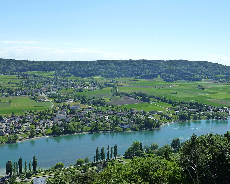
Eschenz
- municipality in Switzerland
Hiking in Eschenz
Eschenz is a charming village located in the municipality of Stein am Rhein in the canton of Thurgau, Switzerland. Situated along the shores of Lake Constance, it offers a unique blend of natural beauty and cultural experience, making it a great destination for hiking enthusiasts....
- Country:
- Postal Code: 8264
- Local Dialing Code: 052
- Licence Plate Code: TG
- Coordinates: 47° 38' 9" N, 8° 52' 18" E
- GPS tracks (wikiloc): [Link]
- AboveSeaLevel: 509 м m
- Area: 12.0 sq km
- Population: 1762
- Web site: [Link]


Berlingen
- municipality in Switzerland
Hiking in Berlingen
Berlingen is a charming village located on the shores of Lake Constance in Switzerland, offering a picturesque setting for hiking enthusiasts. The region is known for its stunning natural beauty, with views of the lake, nearby vineyards, and rolling hills. Here’s what you can expect when hiking around Berlingen:...
- Country:
- Local Dialing Code: 052
- Licence Plate Code: TG
- Coordinates: 47° 39' 59" N, 9° 0' 59" E
- GPS tracks (wikiloc): [Link]
- AboveSeaLevel: 400 м m
- Area: 4.0 sq km
- Population: 903
- Web site: [Link]


Müllheim
- municipality in Switzerland
Hiking in Müllheim
Müllheim, located in the picturesque region of Switzerland, offers a variety of hiking opportunities that cater to different skill levels and preferences. Situated in the canton of Aargau, Müllheim is surrounded by beautiful landscapes, charming villages, and the serene nature of the Swiss countryside. Here are some highlights of hiking in and around Müllheim:...
- Country:
- Postal Code: 8555
- Local Dialing Code: 052
- Licence Plate Code: TG
- Coordinates: 47° 36' 10" N, 9° 0' 13" E
- GPS tracks (wikiloc): [Link]
- AboveSeaLevel: 413 м m
- Area: 8.7 sq km
- Population: 2970
- Web site: [Link]

Wagenhausen
- municipality in the canton of Thurgau, Switzerland
Hiking in Wagenhausen
Wagenhausen is a charming village located in the canton of Thurgau in Switzerland, near the shores of Lake Constance. The region offers a variety of hiking opportunities that cater to different skill levels, making it a great destination for both casual walkers and more experienced hikers....
- Country:
- Postal Code: 8259
- Local Dialing Code: 052
- Licence Plate Code: TG
- Coordinates: 47° 39' 35" N, 8° 50' 55" E
- GPS tracks (wikiloc): [Link]
- AboveSeaLevel: 403 м m
- Area: 11.2 sq km
- Population: 1657
- Web site: [Link]


Hüttlingen
- municipality in Switzerland
Hiking in Hüttlingen
Hüttlingen, located in the scenic region of Switzerland, is an excellent destination for hiking enthusiasts. While Hüttlingen itself may not be as well-known as some larger Swiss hiking destinations, its proximity to stunning natural landscapes and various trails make it a hidden gem for both casual walkers and avid hikers....
- Country:
- Postal Code: 8553
- Local Dialing Code: 052
- Licence Plate Code: TG
- Coordinates: 47° 34' 59" N, 8° 59' 0" E
- GPS tracks (wikiloc): [Link]
- AboveSeaLevel: 411 м m
- Area: 11.6 sq km
- Population: 841
- Web site: [Link]


Uesslingen-Buch
- municipality in Switzerland
Hiking in Uesslingen-Buch
Uesslingen-Buch, located in the canton of Zurich, Switzerland, isn't as widely known as some larger hiking destinations, but it offers a charming landscape for outdoor enthusiasts. The region features rolling hills, lush forests, and beautiful farmland, making it a picturesque setting for hiking....
- Country:
- Postal Code: 8524
- Local Dialing Code: 052
- Licence Plate Code: TG
- Coordinates: 47° 34' 59" N, 8° 49' 0" E
- GPS tracks (wikiloc): [Link]
- AboveSeaLevel: 465 м m
- Area: 14.0 sq km
- Population: 1094
- Web site: [Link]

Hüttwilen
- municipality in Switzerland
Hiking in Hüttwilen
Hüttwilen is a charming village located in the canton of Thurgau in Switzerland, which offers a variety of hiking opportunities. The region is characterized by its beautiful landscapes, rolling hills, and proximity to Lake Constance, making it a lovely destination for outdoor enthusiasts....
- Country:
- Postal Code: 8536
- Local Dialing Code: 052
- Licence Plate Code: TG
- Coordinates: 47° 36' 55" N, 8° 51' 2" E
- GPS tracks (wikiloc): [Link]
- AboveSeaLevel: 498 м m
- Area: 17.6 sq km
- Population: 1715
- Web site: [Link]


Stettfurt
- municipality in Switzerland
Hiking in Stettfurt
Stettfurt, located in the picturesque region of Thurgau in Switzerland, offers a wonderful setting for hiking enthusiasts. The area features a variety of trails that cater to different skill levels, from easy walks suitable for families to more challenging routes for experienced hikers....
- Country:
- Postal Code: 9507
- Local Dialing Code: 052
- Licence Plate Code: TG
- Coordinates: 47° 31' 34" N, 8° 57' 20" E
- GPS tracks (wikiloc): [Link]
- AboveSeaLevel: 488 м m
- Area: 6.4 sq km
- Population: 1210
- Web site: [Link]

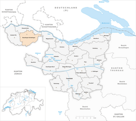
Basadingen-Schlattingen
- municipality in Switzerland
Hiking in Basadingen-Schlattingen
Basadingen-Schlattingen is a charming village located in the canton of Thurgau in Switzerland, known for its picturesque landscapes and access to nature. Hiking in this area is a delightful experience, offering a range of trails that cater to various skill levels and preferences....
- Country:
- Local Dialing Code: 052
- Licence Plate Code: TG
- Coordinates: 47° 40' 0" N, 8° 44' 59" E
- GPS tracks (wikiloc): [Link]
- AboveSeaLevel: 410 м m
- Area: 15.7 sq km
- Population: 1823
- Web site: [Link]


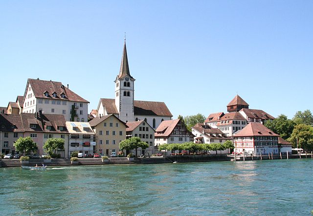
Steckborn
- municipality in Frauenfeld District, Thurgau, Switzerland
Hiking in Steckborn
Steckborn is a charming town located on the shores of Lake Constance in Switzerland, offering beautiful landscapes and numerous hiking opportunities. Hiking in and around Steckborn allows you to explore the scenic beauty of the region, with views of the lake, vineyards, and the nearby hills....
- Country:
- Postal Code: 8266
- Local Dialing Code: 052
- Licence Plate Code: TG
- Coordinates: 47° 39' 59" N, 8° 58' 59" E
- GPS tracks (wikiloc): [Link]
- AboveSeaLevel: 400 м m
- Area: 8.8 sq km
- Population: 3780
- Web site: [Link]

Diessenhofen
- municipality in Switzerland
Hiking in Diessenhofen
Diessenhofen is a charming town located in the canton of Thurgau in Switzerland, near the Rhine River. Hiking in and around Diessenhofen offers a beautiful blend of scenic views, nature, and cultural exploration. Here are some highlights and tips for hiking in this region:...
- Country:
- Postal Code: 8253
- Local Dialing Code: 052
- Licence Plate Code: TG
- Coordinates: 47° 41' 0" N, 8° 44' 59" E
- GPS tracks (wikiloc): [Link]
- AboveSeaLevel: 397 м m
- Area: 10.0 sq km
- Population: 3897
- Web site: [Link]


Homburg
- municipality in Switzerland
Hiking in Homburg
Homburg, located in Switzerland, is a wonderful destination for hiking enthusiasts. While it's known more for its beautiful landscapes and serene environment than for extensive hiking trails, the surrounding areas offer a variety of hiking opportunities that allow you to explore the natural beauty of the Swiss countryside....
- Country:
- Postal Code: 8508
- Local Dialing Code: 052
- Licence Plate Code: TG
- Coordinates: 47° 38' 0" N, 9° 0' 59" E
- GPS tracks (wikiloc): [Link]
- AboveSeaLevel: 574 м m
- Area: 21.1 sq km
- Population: 1532
- Web site: [Link]


Schlatt bei Diessenhofen
- municipality in Switzerland
Hiking in Schlatt bei Diessenhofen
Schlatt is a charming area located in the Canton of Thurgau in Switzerland, known for its beautiful landscapes, rolling hills, and serene countryside. Hiking in this region offers a fantastic opportunity to explore its natural beauty, quaint villages, and local flora and fauna....
- Country:
- Postal Code: 8252
- Local Dialing Code: 052
- Licence Plate Code: TG
- Coordinates: 47° 38' 59" N, 8° 41' 59" E
- GPS tracks (wikiloc): [Link]
- AboveSeaLevel: 416 м m
- Area: 15.5 sq km
- Population: 1678
- Web site: [Link]

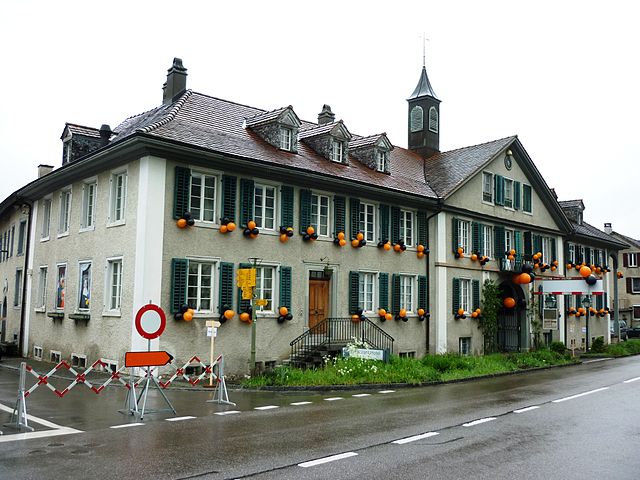
Frauenfeld
- town in, and capital of, the Swiss canton of Thurgau
Hiking in Frauenfeld
Frauenfeld, the capital of the Canton of Thurgau in Switzerland, offers a range of beautiful hiking opportunities that cater to various skill levels, from leisurely walks to challenging hikes. Here are some key points to consider when hiking in and around Frauenfeld:...
- Country:
- Postal Code: 8500
- Local Dialing Code: 052
- Licence Plate Code: TG
- Coordinates: 47° 33' 21" N, 8° 53' 47" E
- GPS tracks (wikiloc): [Link]
- AboveSeaLevel: 417 м m
- Area: 27.4 sq km
- Population: 25442
- Web site: [Link]


Warth-Weiningen
- municipality in Switzerland
Hiking in Warth-Weiningen
Warth-Weiningen is a beautiful region in the Swiss Alps, known for its stunning scenery and excellent hiking opportunities. Here are some key highlights and considerations for hiking in this area:...
- Country:
- Postal Code: 8532
- Local Dialing Code: 052
- Licence Plate Code: TG
- Coordinates: 47° 34' 59" N, 8° 51' 59" E
- GPS tracks (wikiloc): [Link]
- AboveSeaLevel: 445 м m
- Area: 8.3 sq km
- Population: 1317
- Web site: [Link]

Mammern
- municipality in Switzerland
Hiking in Mammern
Mammern is a beautiful location situated on the shores of Lake Constance in Switzerland, offering picturesque landscapes and a variety of outdoor activities, including hiking. Here are some highlights and tips for hiking in the Mammern area:...
- Country:
- Postal Code: 8265
- Local Dialing Code: 052
- Licence Plate Code: TG
- Coordinates: 47° 38' 43" N, 8° 54' 56" E
- GPS tracks (wikiloc): [Link]
- AboveSeaLevel: 448 м m
- Area: 5.5 sq km
- Population: 650
- Web site: [Link]
Shares border with regions:


Weinfelden District
- district of the canton of Thurgau, Switzerland
Hiking in Weinfelden District
Weinfelden District, located in the canton of Thurgau in Switzerland, offers a variety of hiking opportunities that showcase the natural beauty of the region. Here are some highlights for hiking enthusiasts:...
- Country:
- Capital: Weinfelden
- Licence Plate Code: TG
- Coordinates: 47° 34' 0" N, 9° 6' 0" E
- GPS tracks (wikiloc): [Link]
- AboveSeaLevel: 447 м m
- Area: 227.2 sq km


Münchwilen District
- district of the canton of Thurgau, Switzerland
Hiking in Münchwilen District
Münchwilen District, located in the Aargau canton of Switzerland, offers a variety of scenic landscapes and hiking opportunities. The area is characterized by its rolling hills, lush forests, and picturesque villages, making it an ideal spot for both casual and experienced hikers....
- Country:
- Licence Plate Code: TG
- Coordinates: 47° 29' 0" N, 8° 59' 0" E
- GPS tracks (wikiloc): [Link]
- AboveSeaLevel: 518 м m
- Area: 155.86 sq km

Kreuzlingen District
- district of the canton of Thurgau, Switzerland
Hiking in Kreuzlingen District
Kreuzlingen District, located in the canton of Thurgau in Switzerland, offers a variety of scenic hiking opportunities, especially due to its proximity to the beautiful Lake Constance (Bodensee) and the surrounding natural landscapes. Here are some highlights of hiking in the area:...
- Country:
- Capital: Kreuzlingen
- Licence Plate Code: TG
- Coordinates: 47° 38' 0" N, 9° 10' 0" E
- GPS tracks (wikiloc): [Link]
- AboveSeaLevel: 511 м m
- Area: 129 sq km