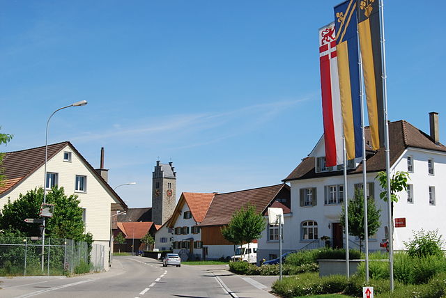
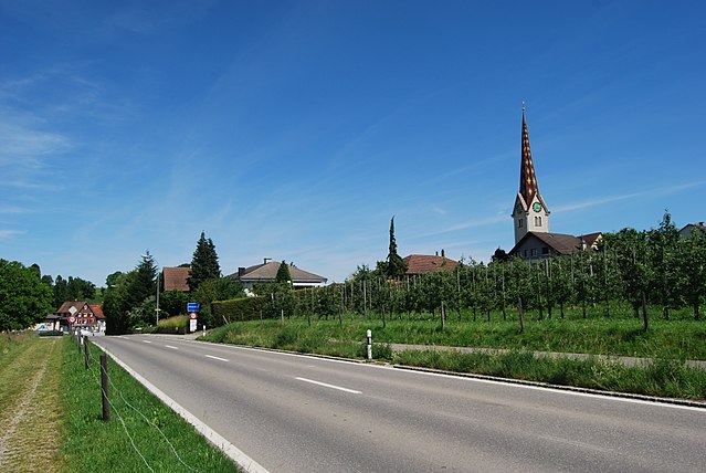
Thundorf (Thundorf)

- municipality in Switzerland
 Hiking in Thundorf
Thundorf is a charming village located in the Thurgau region of Switzerland, surrounded by beautiful landscapes that are perfect for hiking enthusiasts. While it might not be as well-known as some other Swiss hiking destinations, it offers a variety of trails that take you through serene nature, vineyards, and picturesque countryside.
Hiking Highlights in Thundorf
-
Scenic Trails: The area around Thundorf features several well-marked hiking trails ranging from easy to moderate difficulty. You can enjoy the stunning views of rolling hills, fields, and vineyards, which are particularly beautiful during spring and autumn.
-
Regional Park: Thundorf is close to the Thurgau Park, which has multiple trails. These paths often connect to larger networks, allowing for longer hikes or easier loops, depending on your preference.
-
Wine Country: Since Thurgau is known for its vineyards, you can expect some trails to take you through these picturesque landscapes, giving you the chance to enjoy the local wine culture.
-
Connecting Trails: You can easily access neighboring villages such as Amlikon-Bissegg and Neunforn, allowing you to explore various hiking options and immerse yourself in the local culture.
-
Local Flora and Fauna: The region is abundant in natural beauty. Depending on the season, you might see wildflowers, various bird species, and rolling landscapes filled with farmland.
Practical Considerations
-
Best Time to Hike: The ideal seasons for hiking in Thundorf are late spring through early autumn, although winter hiking is also an option if you're prepared for colder conditions and snow.
-
Preparation: Make sure you're equipped with appropriate hiking gear. Good walking shoes, weather-appropriate clothing, and plenty of water are essential.
-
Navigation: Most trails are well-marked, but it's always a good idea to have a hiking map or a GPS device, especially if you plan to venture off the main trails.
-
Local Amenities: Thundorf has small local shops and restaurants where you can enjoy a meal or rest after a hike. Engaging with locals can enhance your experience and provide you with insider tips on the best trails.
Hiking in Thundorf offers a peaceful escape and a unique look at the beautiful Swiss countryside. Whether you are an experienced hiker or a novice, you'll find something enjoyable in this region.
- Country:

- Postal Code: 8512
- Local Dialing Code: 052
- Licence Plate Code: TG
- Coordinates: 47° 32' 50" N, 8° 57' 52" E


- GPS tracks (wikiloc): [Link]
- AboveSeaLevel: 546 м m
- Area: 15.6 sq km
- Population: 1452
- Web site: http://www.thundorf.ch
- Wikipedia en: wiki(en)
- Wikipedia: wiki(de)
- Wikidata storage: Wikidata: Q64847
- Wikipedia Commons Category: [Link]
- Freebase ID: [/m/0g3t0l]
- GeoNames ID: Alt: [2658376]
- OSM relation ID: [1684562]
- HDS ID: [1914]
- Swiss municipality code: [4611]
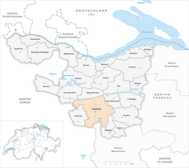
Shares border with regions:


Felben-Wellhausen
- municipality in Switzerland
Hiking in Felben-Wellhausen
Felben-Wellhausen is a charming municipality located in the canton of Thurgau in Switzerland. While it's a small area, it offers a serene environment for hiking enthusiasts who wish to explore the scenic landscapes of the region. Here are some highlights for anyone looking to hike in and around Felben-Wellhausen:...
- Country:
- Postal Code: 8552
- Local Dialing Code: 052
- Licence Plate Code: TG
- Coordinates: 47° 34' 37" N, 8° 56' 34" E
- GPS tracks (wikiloc): [Link]
- AboveSeaLevel: 395 м m
- Area: 7.3 sq km
- Population: 2799
- Web site: [Link]


Matzingen
- municipality in Switzerland
Hiking in Matzingen
Matzingen, located in the canton of Thurgau in Switzerland, offers some lovely hiking opportunities, often accompanied by beautiful landscapes, rolling hills, and picturesque countryside. Here’s an overview to help you with your hiking plans:...
- Country:
- Postal Code: 9548
- Local Dialing Code: 052
- Licence Plate Code: TG
- Coordinates: 47° 31' 36" N, 8° 55' 46" E
- GPS tracks (wikiloc): [Link]
- AboveSeaLevel: 480 м m
- Area: 7.7 sq km
- Population: 2857
- Web site: [Link]

Lommis
- municipality in Switzerland
Hiking in Lommis
Lommis, located in the Thurgau region of Switzerland, offers various hiking opportunities characterized by scenic landscapes, rolling hills, and picturesque vineyards. The region is known for its mild climate, making it an excellent destination for year-round hiking. Here are some insights into hiking in Lommis:...
- Country:
- Postal Code: 9506
- Local Dialing Code: 052
- Licence Plate Code: TG
- Coordinates: 47° 30' 59" N, 8° 58' 59" E
- GPS tracks (wikiloc): [Link]
- AboveSeaLevel: 475 м m
- Area: 8.6 sq km
- Population: 1224
- Web site: [Link]

Amlikon-Bissegg
- municipality in Switzerland
Hiking in Amlikon-Bissegg
Amlikon-Bissegg is a picturesque area in Switzerland, known for its beautiful landscapes and tranquil hiking trails. Located in the canton of Thurgau, it offers a wonderful mix of nature, farms, and rural charm, making it an excellent destination for hikers of all levels....
- Country:
- Postal Code: 8514
- Local Dialing Code: 071
- Licence Plate Code: TG
- Coordinates: 47° 33' 59" N, 9° 2' 59" E
- GPS tracks (wikiloc): [Link]
- AboveSeaLevel: 422 м m
- Area: 14.4 sq km
- Population: 1335
- Web site: [Link]
Affeltrangen
- municipality in Switzerland
Hiking in Affeltrangen
Affeltrangen is a picturesque village located in the canton of Thurgau, Switzerland. The surrounding region offers a variety of hiking opportunities that cater to different skill levels and preferences. Here are some highlights about hiking in and around Affeltrangen:...
- Country:
- Postal Code: 9556
- Local Dialing Code: 071
- Licence Plate Code: TG
- Coordinates: 47° 30' 59" N, 9° 1' 0" E
- GPS tracks (wikiloc): [Link]
- AboveSeaLevel: 489 м m
- Area: 14.4 sq km
- Population: 2562
- Web site: [Link]


Hüttlingen
- municipality in Switzerland
Hiking in Hüttlingen
Hüttlingen, located in the scenic region of Switzerland, is an excellent destination for hiking enthusiasts. While Hüttlingen itself may not be as well-known as some larger Swiss hiking destinations, its proximity to stunning natural landscapes and various trails make it a hidden gem for both casual walkers and avid hikers....
- Country:
- Postal Code: 8553
- Local Dialing Code: 052
- Licence Plate Code: TG
- Coordinates: 47° 34' 59" N, 8° 59' 0" E
- GPS tracks (wikiloc): [Link]
- AboveSeaLevel: 411 м m
- Area: 11.6 sq km
- Population: 841
- Web site: [Link]


Stettfurt
- municipality in Switzerland
Hiking in Stettfurt
Stettfurt, located in the picturesque region of Thurgau in Switzerland, offers a wonderful setting for hiking enthusiasts. The area features a variety of trails that cater to different skill levels, from easy walks suitable for families to more challenging routes for experienced hikers....
- Country:
- Postal Code: 9507
- Local Dialing Code: 052
- Licence Plate Code: TG
- Coordinates: 47° 31' 34" N, 8° 57' 20" E
- GPS tracks (wikiloc): [Link]
- AboveSeaLevel: 488 м m
- Area: 6.4 sq km
- Population: 1210
- Web site: [Link]

Frauenfeld
- town in, and capital of, the Swiss canton of Thurgau
Hiking in Frauenfeld
Frauenfeld, the capital of the Canton of Thurgau in Switzerland, offers a range of beautiful hiking opportunities that cater to various skill levels, from leisurely walks to challenging hikes. Here are some key points to consider when hiking in and around Frauenfeld:...
- Country:
- Postal Code: 8500
- Local Dialing Code: 052
- Licence Plate Code: TG
- Coordinates: 47° 33' 21" N, 8° 53' 47" E
- GPS tracks (wikiloc): [Link]
- AboveSeaLevel: 417 м m
- Area: 27.4 sq km
- Population: 25442
- Web site: [Link]