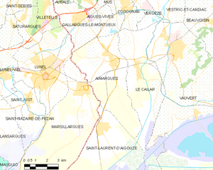
Gallargues-le-Montueux (Gallargues-le-Montueux)

- commune in Gard, France
- Country:

- Postal Code: 30660
- Coordinates: 43° 43' 0" N, 4° 10' 0" E


- GPS tracks (wikiloc): [Link]
- AboveSeaLevel: 64 м m
- Area: 10.89 sq km
- Population: 3669
- Web site: http://www.gallargues.fr
- Wikipedia en: wiki(en)
- Wikipedia: wiki(fr)
- Wikidata storage: Wikidata: Q75014
- Wikipedia Commons Category: [Link]
- Freebase ID: [/m/03c0tcn]
- GeoNames ID: Alt: [3015119]
- SIREN number: [213001233]
- BnF ID: [152547631]
- VIAF ID: Alt: [138533946]
- GND ID: Alt: [4477481-3]
- Library of Congress authority ID: Alt: [n95029516]
- PACTOLS thesaurus ID: [pcrtGIEYTAH4N7]
- INSEE municipality code: 30123
Shares border with regions:


Villetelle
- commune in Hérault, France
- Country:
- Postal Code: 34400
- Coordinates: 43° 44' 2" N, 4° 8' 24" E
- GPS tracks (wikiloc): [Link]
- Area: 5.31 sq km
- Population: 1453
- Web site: [Link]

Aimargues
- commune in Gard, France
- Country:
- Postal Code: 30470
- Coordinates: 43° 41' 5" N, 4° 12' 31" E
- GPS tracks (wikiloc): [Link]
- Area: 26.48 sq km
- Population: 5413
- Web site: [Link]


Lunel
- commune in Hérault, France
- Country:
- Postal Code: 34400
- Coordinates: 43° 40' 37" N, 4° 8' 7" E
- GPS tracks (wikiloc): [Link]
- Area: 23.9 sq km
- Population: 25178
- Web site: [Link]

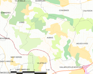
Aubais
- commune in Gard, France
- Country:
- Postal Code: 30250
- Coordinates: 43° 45' 18" N, 4° 8' 52" E
- GPS tracks (wikiloc): [Link]
- Area: 11.79 sq km
- Population: 2602
- Web site: [Link]

Aigues-Vives
- commune in Gard, France
- Country:
- Postal Code: 30670
- Coordinates: 43° 44' 22" N, 4° 10' 50" E
- GPS tracks (wikiloc): [Link]
- Area: 12 sq km
- Population: 3211
- Web site: [Link]