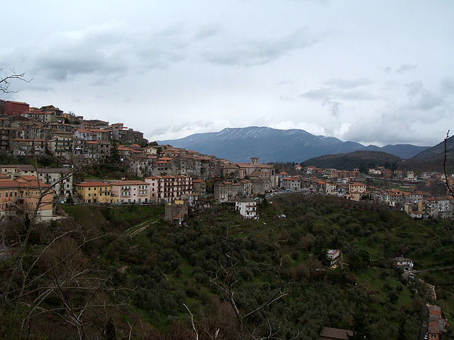
Gavignano (Gavignano)
.svg)
- Italian comune
 Hiking in Gavignano
Gavignano, a charming village in the province of Rome, Italy, offers some beautiful hiking opportunities thanks to its picturesque landscapes and proximity to the Monti Simbruini National Park. Here are some highlights for hiking in and around Gavignano:
Hiking Trails
-
Local Trails: There are various trails around Gavignano that cater to different skill levels. Many local paths can take you through olive groves, vineyards, and quaint countryside scenery.
-
Monti Simbruini National Park: Just a short drive from Gavignano, this park features numerous well-marked trails ranging from easy walks to challenging hikes. The park is known for its rich biodiversity, including forests of beech and fir trees, as well as breathtaking views from its peaks like Monte Autore.
-
Historical and Cultural Routes: Some trails in the region may lead to ancient ruins, monasteries, and historic towns, giving hikers both a physical and cultural adventure.
Best Practices for Hiking
- Prepare Adequately: Make sure to wear appropriate footwear, carry enough water, and pack snacks.
- Check Weather Conditions: Weather can change rapidly in the mountains, so checking forecasts before heading out is crucial.
- Local Guidance: For those unfamiliar with the area, consider hiring a local guide or joining organized hiking groups for a safer experience.
Recommendations
- Visit During Off-Peak Times: To fully enjoy the natural beauty and serenity, try to hike during off-peak times.
- Explore Nearby Towns: After a day of hiking, explore nearby towns like Paliano or Anagni, known for their historical significance and local cuisine.
Safety Tips
- Know Your Limits: Choose trails that match your fitness and experience levels.
- Stay on Marked Paths: Always stick to marked trails to avoid getting lost and to protect the local ecosystem.
Gavignano is a treasure for both seasoned hikers and casual walkers, with its combination of natural beauty and cultural richness. Enjoy your hiking experience!
- Country:

- Postal Code: 00030
- Local Dialing Code: 06
- Licence Plate Code: RM
- Coordinates: 41° 42' 0" N, 13° 3' 0" E


- GPS tracks (wikiloc): [Link]
- AboveSeaLevel: 404 м m
- Area: 15.04 sq km
- Population: 1905
- Web site: http://www.gavignano.rm.gov.it
- Wikipedia en: wiki(en)
- Wikipedia: wiki(it)
- Wikidata storage: Wikidata: Q242668
- Wikipedia Commons Category: [Link]
- Freebase ID: [/m/0djbjv]
- GeoNames ID: Alt: [6539977]
- OSM relation ID: [41481]
- ISTAT ID: 058041
- Italian cadastre code: D945
Shares border with regions:


Anagni
- Italian comune
Hiking in Anagni
Anagni, located in the province of Frosinone in Italy, is a historic town with a rich cultural heritage and beautiful natural landscapes, making it an excellent destination for hiking enthusiasts. Here are some highlights and tips for hiking in the Anagni area:...
- Country:
- Postal Code: 03012
- Local Dialing Code: 0775
- Licence Plate Code: FR
- Coordinates: 41° 45' 0" N, 13° 9' 0" E
- GPS tracks (wikiloc): [Link]
- AboveSeaLevel: 475 м m
- Area: 112.82 sq km
- Population: 21404
- Web site: [Link]
Paliano
- Italian comune
Hiking in Paliano
Paliano, located in the province of Frosinone in the Lazio region of Italy, is an area known for its picturesque landscapes and historical significance. Hiking in Paliano can provide an excellent opportunity to explore both natural beauty and cultural sites....
- Country:
- Postal Code: 03018
- Local Dialing Code: 0775
- Licence Plate Code: FR
- Coordinates: 41° 48' 0" N, 13° 3' 0" E
- GPS tracks (wikiloc): [Link]
- AboveSeaLevel: 471 м m
- Area: 70.64 sq km
- Population: 8163
- Web site: [Link]


Colleferro
- Italian comune
Hiking in Colleferro
Colleferro, located in the Lazio region of Italy, offers a variety of hiking opportunities thanks to its picturesque landscapes and proximity to the beautiful Monti Lepini mountain range. Here’s a breakdown of what you can expect when hiking in and around Colleferro:...
- Country:
- Postal Code: 00034
- Local Dialing Code: 06
- Licence Plate Code: ROMA
- Coordinates: 41° 43' 43" N, 13° 0' 11" E
- GPS tracks (wikiloc): [Link]
- AboveSeaLevel: 218 м m
- Area: 27 sq km
- Population: 21394
- Web site: [Link]
Gorga
- Italian comune
Hiking in Gorga
Gorga, a small town in the province of Rome, Lazio, is surrounded by beautiful natural landscapes, making it an excellent destination for hiking enthusiasts. The area offers a variety of trails that cater to different levels of experience, from leisurely walks to more challenging treks....
- Country:
- Postal Code: 00030
- Local Dialing Code: 06
- Licence Plate Code: RM
- Coordinates: 41° 39' 0" N, 13° 7' 0" E
- GPS tracks (wikiloc): [Link]
- AboveSeaLevel: 766 м m
- Area: 26.19 sq km
- Population: 712
- Web site: [Link]
Montelanico
- Italian comune
Hiking in Montelanico
Montelanico is a charming town located in the Lazio region of central Italy, known for its beautiful landscapes and proximity to the Apennine mountains. Hiking in and around Montelanico offers a unique opportunity to explore stunning natural scenery, charming villages, and a rich array of local flora and fauna. Here are some key points to consider when hiking in this area:...
- Country:
- Postal Code: 00030
- Local Dialing Code: 06
- Licence Plate Code: ROMA
- Coordinates: 41° 39' 0" N, 13° 2' 23" E
- GPS tracks (wikiloc): [Link]
- AboveSeaLevel: 297 м m
- Area: 35.14 sq km
- Population: 2125
- Web site: [Link]

Segni
- Italian comune
Hiking in Segni
Segni, located in the province of Rome, Italy, offers a range of hiking opportunities with its beautiful landscapes, historical sites, and varied terrain. Nestled in the foothills of the Lepini Mountains, this area is perfect for outdoor enthusiasts looking to explore nature while appreciating the rich cultural heritage of the region....
- Country:
- Postal Code: 00037
- Local Dialing Code: 06
- Licence Plate Code: RM
- Coordinates: 41° 41' 0" N, 13° 1' 0" E
- GPS tracks (wikiloc): [Link]
- AboveSeaLevel: 668 м m
- Area: 60.86 sq km
- Population: 9192
- Web site: [Link]