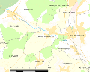
Gumbrechtshoffen (Gumbrechtshoffen)
- commune in Bas-Rhin, France
- Country:

- Postal Code: 67110
- Coordinates: 48° 54' 18" N, 7° 37' 49" E


- GPS tracks (wikiloc): [Link]
- Area: 5.74 sq km
- Population: 1160
- Web site: http://www.mairie-gumbrechtshoffen.fr
- Wikipedia en: wiki(en)
- Wikipedia: wiki(fr)
- Wikidata storage: Wikidata: Q21540
- Wikipedia Commons Category: [Link]
- Freebase ID: [/m/03m9834]
- Freebase ID: [/m/03m9834]
- GeoNames ID: Alt: [6441126]
- GeoNames ID: Alt: [6441126]
- SIREN number: [216701748]
- SIREN number: [216701748]
- BnF ID: [15271317f]
- BnF ID: [15271317f]
- INSEE municipality code: 67174
- INSEE municipality code: 67174
Shares border with regions:


Reichshoffen
- commune in Bas-Rhin, France
- Country:

- Postal Code: 67110
- Coordinates: 48° 56' 4" N, 7° 39' 58" E


- GPS tracks (wikiloc): [Link]
- Area: 17.64 sq km
- Population: 5397
- Web site: [Link]

Oberbronn
- commune in Bas-Rhin, France
- Country:

- Postal Code: 67110
- Coordinates: 48° 56' 28" N, 7° 36' 25" E


- GPS tracks (wikiloc): [Link]
- Area: 21.15 sq km
- Population: 1542
- Web site: [Link]


Engwiller
- commune in Bas-Rhin, France
- Country:

- Postal Code: 67350
- Coordinates: 48° 53' 6" N, 7° 36' 55" E


- GPS tracks (wikiloc): [Link]
- Area: 3.74 sq km
- Population: 496
- Web site: [Link]


Zinswiller
- commune in Bas-Rhin, France
- Country:

- Postal Code: 67110
- Coordinates: 48° 55' 12" N, 7° 35' 27" E


- GPS tracks (wikiloc): [Link]
- AboveSeaLevel: 260 м m
- Area: 7.14 sq km
- Population: 774


Uttenhoffen
- commune in Bas-Rhin, France
- Country:

- Postal Code: 67110
- Coordinates: 48° 53' 33" N, 7° 39' 18" E


- GPS tracks (wikiloc): [Link]
- Area: 1.95 sq km
- Population: 195


Gundershoffen
- commune in Bas-Rhin, France
- Country:

- Postal Code: 67110
- Coordinates: 48° 54' 20" N, 7° 39' 47" E


- GPS tracks (wikiloc): [Link]
- Area: 17.55 sq km
- Population: 3633
- Web site: [Link]


Uhrwiller
- commune in Bas-Rhin, France
- Country:

- Postal Code: 67350
- Coordinates: 48° 52' 40" N, 7° 34' 43" E


- GPS tracks (wikiloc): [Link]
- Area: 11.02 sq km
- Population: 706
- Web site: [Link]
