Igney (Igney)

- commune in Meurthe-et-Moselle, France
- Country:

- Postal Code: 54450
- Coordinates: 48° 38' 2" N, 6° 48' 50" E


- GPS tracks (wikiloc): [Link]
- AboveSeaLevel: 350 м m
- Area: 4.71 sq km
- Population: 128
- Wikipedia en: wiki(en)
- Wikipedia: wiki(fr)
- Wikidata storage: Wikidata: Q635163
- Wikipedia Commons Category: [Link]
- Freebase ID: [/m/03qdj7n]
- Freebase ID: [/m/03qdj7n]
- GeoNames ID: Alt: [6617050]
- GeoNames ID: Alt: [6617050]
- SIREN number: [215402710]
- SIREN number: [215402710]
- BnF ID: [15264340g]
- BnF ID: [15264340g]
- VIAF ID: Alt: [140958707]
- VIAF ID: Alt: [140958707]
- Library of Congress authority ID: Alt: [n2010032819]
- Library of Congress authority ID: Alt: [n2010032819]
- INSEE municipality code: 54271
- INSEE municipality code: 54271
Shares border with regions:

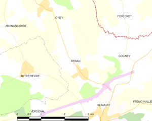
Repaix
- commune in Meurthe-et-Moselle, France
- Country:
- Postal Code: 54450
- Coordinates: 48° 36' 28" N, 6° 49' 58" E
- GPS tracks (wikiloc): [Link]
- Area: 4.86 sq km
- Population: 90

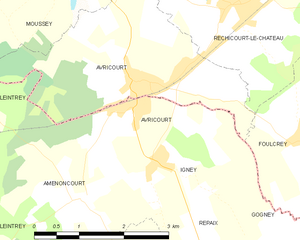
Avricourt
- commune in Meurthe-et-Moselle, France
- Country:
- Postal Code: 54450
- Coordinates: 48° 38' 41" N, 6° 48' 21" E
- GPS tracks (wikiloc): [Link]
- AboveSeaLevel: 310 м m
- Area: 2.25 sq km
- Population: 385

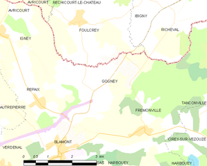
Gogney
- commune in Meurthe-et-Moselle, France
- Country:
- Postal Code: 54450
- Coordinates: 48° 36' 49" N, 6° 51' 31" E
- GPS tracks (wikiloc): [Link]
- Area: 8.8 sq km
- Population: 47

Autrepierre
- commune in Meurthe-et-Moselle, France
- Country:
- Postal Code: 54450
- Coordinates: 48° 36' 42" N, 6° 48' 4" E
- GPS tracks (wikiloc): [Link]
- Area: 7.75 sq km
- Population: 81

Foulcrey
- commune in Moselle, France
- Country:
- Postal Code: 57830
- Coordinates: 48° 38' 16" N, 6° 51' 26" E
- GPS tracks (wikiloc): [Link]
- Area: 12.34 sq km
- Population: 190


Amenoncourt
- commune in Meurthe-et-Moselle, France
- Country:
- Postal Code: 54450
- Coordinates: 48° 37' 40" N, 6° 47' 20" E
- GPS tracks (wikiloc): [Link]
- Area: 7.23 sq km
- Population: 82