Repaix (Repaix)

- commune in Meurthe-et-Moselle, France
- Country:

- Postal Code: 54450
- Coordinates: 48° 36' 28" N, 6° 49' 58" E


- GPS tracks (wikiloc): [Link]
- Area: 4.86 sq km
- Population: 90
- Wikipedia en: wiki(en)
- Wikipedia: wiki(fr)
- Wikidata storage: Wikidata: Q192750
- Wikipedia Commons Category: [Link]
- Freebase ID: [/m/03qdmnd]
- Freebase ID: [/m/03qdmnd]
- GeoNames ID: Alt: [6612630]
- GeoNames ID: Alt: [6612630]
- SIREN number: [215404583]
- SIREN number: [215404583]
- BnF ID: [152645254]
- BnF ID: [152645254]
- VIAF ID: Alt: [243841524]
- VIAF ID: Alt: [243841524]
- Global Anabaptist Mennonite Encyclopedia Online ID: [Repaix (Meurthe-et-Moselle, Lorraine, France)]
- Global Anabaptist Mennonite Encyclopedia Online ID: [Repaix (Meurthe-et-Moselle, Lorraine, France)]
- INSEE municipality code: 54458
- INSEE municipality code: 54458
Shares border with regions:

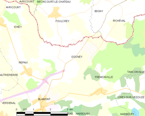
Gogney
- commune in Meurthe-et-Moselle, France
- Country:
- Postal Code: 54450
- Coordinates: 48° 36' 49" N, 6° 51' 31" E
- GPS tracks (wikiloc): [Link]
- Area: 8.8 sq km
- Population: 47

Autrepierre
- commune in Meurthe-et-Moselle, France
- Country:
- Postal Code: 54450
- Coordinates: 48° 36' 42" N, 6° 48' 4" E
- GPS tracks (wikiloc): [Link]
- Area: 7.75 sq km
- Population: 81


Verdenal
- commune in Meurthe-et-Moselle, France
- Country:
- Postal Code: 54450
- Coordinates: 48° 35' 1" N, 6° 48' 40" E
- GPS tracks (wikiloc): [Link]
- Area: 6.54 sq km
- Population: 154


Blâmont
- commune in Meurthe-et-Moselle, France
- Country:
- Postal Code: 54450
- Coordinates: 48° 35' 23" N, 6° 50' 32" E
- GPS tracks (wikiloc): [Link]
- Area: 7.41 sq km
- Population: 1091

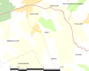
Igney
- commune in Meurthe-et-Moselle, France
- Country:
- Postal Code: 54450
- Coordinates: 48° 38' 2" N, 6° 48' 50" E
- GPS tracks (wikiloc): [Link]
- AboveSeaLevel: 350 м m
- Area: 4.71 sq km
- Population: 128