Karlshorst (Karlshorst)
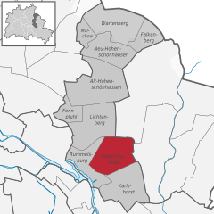
- locality of Berlin
Karlshorst, a district in Berlin, Germany, is not typically known as a traditional hiking destination, as it is more urbanized compared to rural nature areas. However, there are opportunities for walking and enjoying the outdoors in and around the area. Here are some details and suggestions for a hiking-like experience in Karlshorst:
Parks and Green Spaces:
-
Wuhlheide Park: This large park is to the south of Karlshorst and offers a network of trails, wooded areas, and natural beauty. It’s great for long walks, picnics, and enjoying the local flora and fauna.
-
Treptower Park: Located a bit further away, but still accessible from Karlshorst, this park offers beautiful paths alongside the Spree River. The park contains lush greenery, sculptures, and the impressive Soviet War Memorial.
-
Köpenick Forest: If you're willing to travel a bit further from Karlshorst, the Köpenick Forest provides a more natural environment for hiking. You can explore diverse trails that take you through wooded areas and beside lakes.
Trails and Routes:
-
Spree River Trail: This trail runs alongside the river and can be accessed from various points in Karlshorst, offering picturesque views and a chance to see local wildlife.
-
Berlin's Green Ring: A longer trail that encircles the city and can be connected through public transport. It offers a chance to hike through various Berlin districts and experience different parks.
Activities:
-
Walking/Biking: The urban trails and parks around Karlshorst are great for walking and biking. Bring your bike along for a more extensive exploration of the area.
-
Guided Nature Walks: Look for guided nature walks or local hiking clubs that may offer excursions in nearby green spaces.
Tips for Hiking in Karlshorst:
- Public Transportation: Use Berlin's efficient public transport system to reach nearby parks and natural areas.
- Gear: Wear comfortable walking shoes and dress appropriately for the weather.
- Hydration and Snacks: Bring water and snacks, especially if you plan on walking for an extended time.
While Karlshorst may not offer the rugged hiking terrains found in mountains or national parks, its parks and accessible green spaces can still provide a lovely escape into nature right in the heart of Berlin.
- Country:

- Coordinates: 52° 28' 57" N, 13° 31' 33" E


- GPS tracks (wikiloc): [Link]
- AboveSeaLevel: 36 м m
- Area: 6.6 sq km
- Wikipedia en: wiki(en)
- Wikipedia: wiki(de)
- Wikidata storage: Wikidata: Q703218
- Wikipedia Commons Gallery: [Link]
- Wikipedia Commons Category: [Link]
- Wikipedia Commons Maps Category: [Link]
- Freebase ID: [/m/063sk6]
- GeoNames ID: Alt: [2892811]
- VIAF ID: Alt: [140881998]
- OSM relation ID: [409207]
- archINFORM location ID: [43231]
- Library of Congress authority ID: Alt: [n95091089]
Shares border with regions:


Köpenick
- locality of Berlin
Köpenick is a district in the southeast of Berlin, Germany, and is known for its beautiful natural landscapes, historic architecture, and proximity to water. While Köpenick itself is more urban than rural, there are several opportunities for hiking and outdoor activities in and around the area. Here are some highlights for hiking in Köpenick:...
- Country:

- Postal Code: 12587; 12559; 12557; 12555; 12459
- Coordinates: 52° 26' 45" N, 13° 34' 38" E


- GPS tracks (wikiloc): [Link]
- AboveSeaLevel: 32 м m
- Area: 34.9 sq km
- Population: 62569


Rummelsburg
- locality of Berlin
Rummelsburg is a neighborhood in Berlin, Germany, known more for its urban environment than traditional hiking trails. However, if you're looking for hiking-like experiences in and around Rummelsburg, there are a few options worth considering:...
- Country:

- Coordinates: 52° 30' 0" N, 13° 29' 33" E


- GPS tracks (wikiloc): [Link]
- AboveSeaLevel: 40 м m
- Area: 4.52 sq km


Friedrichsfelde
- locality of Berlin
Friedrichsfelde is a district located in the eastern part of Berlin, Germany. It is known for its parkland and green spaces, making it a lovely area for hiking and outdoor activities. If you’re looking to hike in Friedrichsfelde, here are some details you might find useful:...
- Country:

- Coordinates: 52° 30' 21" N, 13° 31' 9" E


- GPS tracks (wikiloc): [Link]
- AboveSeaLevel: 39 м m
- Area: 5.55 sq km
- Population: 52502


Oberschöneweide
- locality of Berlin
Oberschöneweide is a district in the borough of Treptow-Köpenick in Berlin, Germany. While it's primarily known for its industrial history and urban environment, there are still opportunities for hiking and enjoying nature in and around the area....
- Country:

- Coordinates: 52° 27' 43" N, 13° 30' 54" E


- GPS tracks (wikiloc): [Link]
- AboveSeaLevel: 36 м m
- Area: 6.18 sq km
- Population: 18919


Biesdorf
- locality of Berlin
Biesdorf is a district located in the eastern part of Berlin, Germany. While it is primarily an urban area, there are still outdoor opportunities for walking and enjoying nature. Here are some highlights for hiking or walking in and around Biesdorf:...
- Country:

- Postal Code: 12683
- Coordinates: 52° 30' 33" N, 13° 33' 19" E


- GPS tracks (wikiloc): [Link]
- AboveSeaLevel: 44 м m
- Area: 12.44 sq km
- Population: 25622

