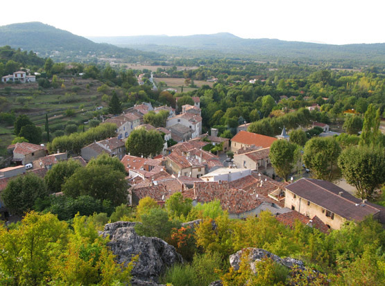
La Celle (La Celle)

- commune in Var, France
 Hiking in La Celle
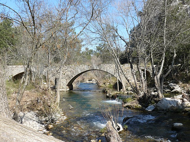
La Celle, a charming village nestled in the Var department of Provence-Alpes-Côte d'Azur, offers beautiful hiking opportunities amidst stunning natural scenery. The region is characterized by its picturesque landscapes, rolling hills, vineyards, and historical sites. Here are some highlights and tips for hiking in and around La Celle:
Hiking Trails
-
Local Trails: There are several well-marked trails around La Celle that cater to various skill levels. Many routes provide breathtaking views of the surrounding vineyards and hills.
-
Sentier des Vignerons: This trail is particularly popular as it winds through the local vineyards, allowing hikers to appreciate the local wine culture while enjoying nature. It's often an easy to moderate hike, perfect for families.
-
Nature Reserves: The nearby nature reserves and protected areas offer more challenging hikes with diverse flora and fauna. Be sure to explore some of the well-known trails in the region, like those in the Sainte-Baume or the Verdon Regional Natural Park.
Points of Interest
- Historical Sites: While hiking, you may come across ancient ruins and churches, like the old chapel of St. Antoine, which adds a cultural dimension to your outdoor experience.
- Flora and Fauna: The region is home to diverse wildlife and beautiful plants, making it ideal for nature enthusiasts and bird watchers.
Best Practices
- Check the Weather: The Mediterranean climate can change rapidly, so be sure to check the weather forecast before heading out.
- Stay Hydrated: Always carry enough water, especially during warmer months, as some trails might not have water sources nearby.
- Dress Appropriately: Wear sturdy hiking boots and dress in layers to accommodate the changing temperatures.
- Follow Trails: Stick to marked paths to preserve the environment and for your safety.
When to Go
- Spring and Fall: These seasons are ideal for hiking in La Celle, as the temperatures are mild, and the scenery is particularly beautiful with blooming wildflowers in spring and autumn foliage.
Local Resources
- Tourist Information Center: For the most current trail maps and information, visit the local tourist information center or website prior to your hike.
In conclusion, La Celle provides ample opportunities for an enjoyable hiking experience, whether you're looking for a leisurely stroll through vineyards or a more adventurous trek in the surrounding hills. Enjoy your hike and the gorgeous landscapes it has to offer!
- Country:

- Postal Code: 83170
- Coordinates: 43° 23' 39" N, 6° 2' 26" E


- GPS tracks (wikiloc): [Link]
- Area: 21 sq km
- Population: 1433
- Wikipedia en: wiki(en)
- Wikipedia: wiki(fr)
- Wikidata storage: Wikidata: Q1772424
- Wikipedia Commons Category: [Link]
- Freebase ID: [/m/03qhfc6]
- GeoNames ID: Alt: [6457116]
- SIREN number: [218300374]
- BnF ID: [15277864s]
- PACTOLS thesaurus ID: [pcrtMLSk67ZkOz]
- INSEE municipality code: 83037
Shares border with regions:

Mazaugues
- commune in Var, France
Hiking in Mazaugues
Mazaugues is a charming village located in the Var department of the Provence-Alpes-Côte d'Azur region in southeastern France. It is surrounded by beautiful landscapes, making it a great destination for hiking enthusiasts. Here are some highlights about hiking in and around Mazaugues:...
- Country:
- Postal Code: 83136
- Coordinates: 43° 20' 51" N, 5° 55' 19" E
- GPS tracks (wikiloc): [Link]
- Area: 53.79 sq km
- Population: 887


Brignoles
- commune in Var, France
Hiking in Brignoles
Brignoles, located in the Var department in southeastern France, is surrounded by beautiful landscapes that offer excellent opportunities for hiking and outdoor activities. Here are some highlights and tips for hiking around Brignoles:...
- Country:
- Postal Code: 83170
- Coordinates: 43° 24' 21" N, 6° 3' 42" E
- GPS tracks (wikiloc): [Link]
- Area: 70.53 sq km
- Population: 17093
- Web site: [Link]


La Roquebrussanne
- commune in Var, France
Hiking in La Roquebrussanne
La Roquebrussanne, a charming village located in the Var department of the Provence-Alpes-Côte d'Azur region in southeastern France, is surrounded by picturesque landscapes that are perfect for hiking enthusiasts. The area features a variety of trails that cater to different skill levels, offering opportunities to explore beautiful natural scenery, including forests, hills, and vineyards....
- Country:
- Postal Code: 83136
- Coordinates: 43° 20' 25" N, 5° 58' 35" E
- GPS tracks (wikiloc): [Link]
- Area: 37.05 sq km
- Population: 2540

Tourves
- commune in Var, France
Hiking in Tourves
Tourves is a charming commune located in the Var department of the Provence-Alpes-Côte d'Azur region in southeastern France. It is surrounded by stunning landscapes, including rolling hills, vineyards, and picturesque countryside, making it an ideal spot for hiking enthusiasts....
- Country:
- Postal Code: 83170
- Coordinates: 43° 24' 29" N, 5° 55' 26" E
- GPS tracks (wikiloc): [Link]
- Area: 65.62 sq km
- Population: 4973