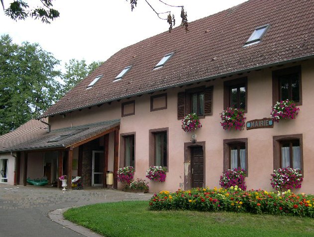
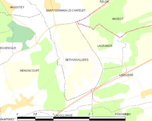
Lagrange (Lagrange)
- commune in Territoire de Belfort, France
Lagrange, located in the Territoire de Belfort region in France, offers a serene hiking experience amidst beautiful natural landscapes. This area is characterized by rolling hills, dense forests, and picturesque countryside, making it a wonderful destination for outdoor enthusiasts.
Hiking Opportunities
-
Scenic Trails: There are various trails suitable for different skill levels. Many paths lead through the woods and across open fields, providing opportunities to enjoy the local flora and fauna.
-
Regional Nature Reserves: The nearby nature reserves and parks, such as the Ballon d'Alsace Regional Nature Park, offer extended hiking routes with varying levels of difficulty. You can expect breathtaking views of the Vosges Mountains and the Jura range.
-
Historical Sites: The area is rich in history, so some hikes may include visits to local landmarks and ruins, enhancing your experience with cultural knowledge.
Preparing for Your Hike
- Trail Maps: It's recommended to have a detailed map or a hiking app to ensure you stay on track.
- Adequate Gear: Wear proper hiking boots and clothing suitable for the weather. Always be prepared for changing conditions.
- Hydration and Snacks: Carry enough water and lightweight snacks to keep your energy levels up during your hike.
Tips
- Local Guides: Consider hiring a local guide to enrich your hiking experience with knowledge of the area's ecology and history.
- Respect Nature: Stay on marked trails, take your litter back with you, and respect wildlife.
Seasonal Considerations
- Spring and Autumn: These are often the best times to hike in the region, as temperatures are mild and the landscapes are particularly beautiful, with spring flowers or autumn foliage.
- Winter Hiking: If you enjoy winter sports, check local conditions for snowshoeing or winter hiking trails in the area.
In summary, Lagrange and the surrounding Territoire de Belfort region provide a variety of hiking experiences that cater to different interests and skill levels, making it a great spot for those looking to immerse themselves in nature. Always check local conditions and regulations before setting out on your hike!
- Country:

- Postal Code: 90150
- Coordinates: 47° 40' 50" N, 6° 58' 45" E


- GPS tracks (wikiloc): [Link]
- Area: 0.93 sq km
- Population: 125
- Wikipedia en: wiki(en)
- Wikipedia: wiki(fr)
- Wikidata storage: Wikidata: Q915277
- Wikipedia Commons Category: [Link]
- Freebase ID: [/m/03mhf6c]
- Freebase ID: [/m/03mhf6c]
- Freebase ID: [/m/03mhf6c]
- GeoNames ID: Alt: [6451910]
- GeoNames ID: Alt: [6451910]
- GeoNames ID: Alt: [6451910]
- SIREN number: [219000601]
- SIREN number: [219000601]
- SIREN number: [219000601]
- BnF ID: [152800016]
- BnF ID: [152800016]
- BnF ID: [152800016]
- INSEE municipality code: 90060
- INSEE municipality code: 90060
- INSEE municipality code: 90060
Shares border with regions:


Angeot
- commune in Territoire de Belfort, France
It seems there might be a typo or confusion regarding "Angeot." If you meant "Angiot," it’s not a recognized location for hiking that I'm aware of up to 2023. However, if you meant to refer to a specific region or area known for hiking, such as a national park or a famous trail, please clarify so I can provide more tailored information....
- Country:

- Postal Code: 90150
- Coordinates: 47° 41' 47" N, 7° 0' 50" E


- GPS tracks (wikiloc): [Link]
- Area: 6.56 sq km
- Population: 336
- Web site: [Link]


Bethonvilliers
- commune in Territoire de Belfort, France
Bethonvilliers, a picturesque village in the French countryside, offers beautiful hiking opportunities for both beginners and experienced hikers. The surrounding area is characterized by rolling hills, lush forests, and charming rural landscapes, making it an ideal location for outdoor activities....
- Country:

- Postal Code: 90150
- Coordinates: 47° 40' 50" N, 6° 57' 44" E


- GPS tracks (wikiloc): [Link]
- Area: 1.9 sq km
- Population: 254


Saint-Germain-le-Châtelet
- commune in Territoire de Belfort, France
- Country:

- Postal Code: 90110
- Coordinates: 47° 41' 46" N, 6° 57' 31" E


- GPS tracks (wikiloc): [Link]
- Area: 3.36 sq km
- Population: 640

Larivière
- commune in Territoire de Belfort, France
Larivière, located in the Territoire de Belfort region in eastern France, offers a variety of hiking opportunities that showcase the beautiful landscapes of this area. This region is characterized by its rolling hills, dense forests, and scenic views of the surrounding countryside....
- Country:

- Postal Code: 90150
- Coordinates: 47° 40' 35" N, 6° 59' 52" E


- GPS tracks (wikiloc): [Link]
- Area: 4.84 sq km
- Population: 325

