Le Cailar (Le Cailar)

- commune in Gard, France
- Country:

- Postal Code: 30740
- Coordinates: 43° 40' 33" N, 4° 14' 10" E


- GPS tracks (wikiloc): [Link]
- Area: 30.01 sq km
- Population: 2401
- Wikipedia en: wiki(en)
- Wikipedia: wiki(fr)
- Wikidata storage: Wikidata: Q844798
- Wikipedia Commons Category: [Link]
- Freebase ID: [/m/03c0v5f]
- GeoNames ID: Alt: [3004891]
- SIREN number: [213000599]
- BnF ID: [152547004]
- VIAF ID: Alt: [248256598]
- PACTOLS thesaurus ID: [pcrt43uWSS2eyj]
- INSEE municipality code: 30059
Shares border with regions:

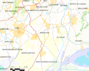
Aimargues
- commune in Gard, France
- Country:
- Postal Code: 30470
- Coordinates: 43° 41' 5" N, 4° 12' 31" E
- GPS tracks (wikiloc): [Link]
- Area: 26.48 sq km
- Population: 5413
- Web site: [Link]


Codognan
- commune in Gard, France
- Country:
- Postal Code: 30920
- Coordinates: 43° 43' 54" N, 4° 13' 11" E
- GPS tracks (wikiloc): [Link]
- Area: 4.65 sq km
- Population: 2422
- Web site: [Link]


Vauvert
- commune in Gard, France
- Country:
- Postal Code: 30600
- Coordinates: 43° 41' 36" N, 4° 16' 34" E
- GPS tracks (wikiloc): [Link]
- Area: 109.86 sq km
- Population: 11515
- Web site: [Link]


Vergèze
- commune in Gard, France
- Country:
- Postal Code: 30310
- Coordinates: 43° 44' 36" N, 4° 13' 12" E
- GPS tracks (wikiloc): [Link]
- Area: 10.16 sq km
- Population: 5051
- Web site: [Link]

Aigues-Vives
- commune in Gard, France
- Country:
- Postal Code: 30670
- Coordinates: 43° 44' 22" N, 4° 10' 50" E
- GPS tracks (wikiloc): [Link]
- Area: 12 sq km
- Population: 3211
- Web site: [Link]


Vestric-et-Candiac
- commune in Gard, France
- Country:
- Postal Code: 30600
- Coordinates: 43° 44' 24" N, 4° 15' 33" E
- GPS tracks (wikiloc): [Link]
- Area: 10.92 sq km
- Population: 1428
- Web site: [Link]


Saint-Laurent-d'Aigouze
- commune in Gard, France
- Country:
- Postal Code: 30220
- Coordinates: 43° 38' 4" N, 4° 11' 44" E
- GPS tracks (wikiloc): [Link]
- Area: 89.81 sq km
- Population: 3458
- Web site: [Link]