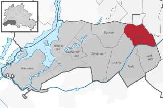
Lichterfelde (Lichterfelde)
- locality of Berlin, Germany
Lichterfelde is a district in the southwestern part of Berlin, known for its residential areas, parks, and greenery. While it may not be a traditional hiking destination like larger natural reserves or mountainous regions, there are still opportunities for enjoyable walking and hiking experiences in and around this area.
Hiking Opportunities in Lichterfelde:
-
Parks and Green Spaces:
- Botanical Garden Berlin: Not far from Lichterfelde, the Berlin Botanical Garden offers scenic walking paths amidst a diverse array of plants. While technically not a “hike,” the extensive grounds are perfect for leisurely strolls.
- Grunewald Forest: Located a short distance away, Grunewald is one of the largest green spaces in Berlin. It offers various trails for hiking, where you can enjoy nature, lakes, and even hilltops with views of the surrounding area.
- Lichterfelder Park: Within the neighborhood, this park provides walking paths and areas for relaxation.
-
Nearby Hiking Trails:
- Teltow Canal Path: This path runs along the Teltow Canal and offers a pleasant walk or bike ride. You can enjoy the scenic views of the water and surrounding nature.
- Krumme Lanke: Located close to Lichterfelde, Krumme Lanke is a popular spot for walking, jogging, and cycling. The area features trails around the lake and into the adjacent woods.
-
Urban Hiking:
- Lichterfelde and nearby districts can also be explored through urban hiking routes. Walking from Lichterfelde to neighboring areas like Zehlendorf or Steglitz can provide a mix of urban and natural landscapes.
Tips for Hiking in Lichterfelde:
- Footwear: Wear comfortable walking or hiking shoes, especially if you plan to explore forested or uneven terrain.
- Weather: Check the weather forecast and dress accordingly. Berlin’s weather can vary, so layers can be helpful.
- Hydration and Snacks: Bring water and some snacks, especially if you plan to spend a few hours exploring.
- Map and Guide: While many paths are well-marked, carrying a map or using a GPS app can help you discover more hidden trails and ensure you stay on the right path.
Conclusion:
While Lichterfelde may not be a major hiking destination, it offers opportunities for pleasant walks and connections to larger parks and trails nearby. Whether you choose to explore urban paths or venture into the surrounding natural areas, there is plenty to enjoy in this green part of Berlin.
- Country:

- Postal Code: 14167; 12209; 12207; 12205; 12203
- Coordinates: 52° 26' 0" N, 13° 19' 0" E


- GPS tracks (wikiloc): [Link]
- AboveSeaLevel: 47 м m
- Area: 18.22 sq km
- Population: 81831
- Wikipedia en: wiki(en)
- Wikipedia: wiki(de)
- Wikidata storage: Wikidata: Q155211
- Wikipedia Commons Gallery: [Link]
- Wikipedia Commons Category: [Link]
- Wikipedia Commons Maps Category: [Link]
- Freebase ID: [/m/03c1flk]
- GeoNames ID: Alt: [2878018]
- VIAF ID: Alt: [244097441]
- OSM relation ID: [55737]
- GND ID: Alt: [4087328-6]
- archINFORM location ID: [43201]
- Library of Congress authority ID: Alt: [n99026561]
Shares border with regions:


Zehlendorf
- locality of Berlin
Zehlendorf, located in the southwestern part of Berlin, is known for its beautiful natural surroundings, making it a great spot for hiking enthusiasts. Here are some key aspects to consider when planning a hiking trip in this area:...
- Country:

- Postal Code: 14169; 14167; 14165; 14163
- Coordinates: 52° 26' 2" N, 13° 15' 32" E


- GPS tracks (wikiloc): [Link]
- Area: 18.83 sq km
- Population: 58589


Lankwitz
- locality of Berlin
Lankwitz is a district in the southwestern part of Berlin, Germany. While it may not be known for traditional hiking in the way that larger nature reserves or mountain regions are, there are still opportunities for enjoyable walks and hikes in and around the area....
- Country:

- Postal Code: 12249; 12247
- Coordinates: 52° 26' 0" N, 13° 21' 0" E


- GPS tracks (wikiloc): [Link]
- AboveSeaLevel: 43 м m
- Area: 6.99 sq km
- Population: 41955


Marienfelde
- locality of Berlin, Germany
Marienfelde is a district located in the southwestern part of Berlin, Germany. While it may not be a traditional hiking destination with extensive trails like you might find in national parks, there are still some opportunities for walking and exploring the natural surroundings in and around the area....
- Country:

- Postal Code: 12249; 12279; 12277
- Coordinates: 52° 25' 0" N, 13° 22' 0" E


- GPS tracks (wikiloc): [Link]
- AboveSeaLevel: 44 м m
- Area: 9.15 sq km
- Population: 31372


Steglitz
- locality of Berlin
Steglitz is a district located in Berlin, Germany, and it offers several opportunities for outdoor activities, including hiking. While Steglitz itself might not have extensive hiking trails like some of the more rural areas surrounding Berlin, there are still some pleasant parks and natural areas where you can enjoy walking and light hiking. Here are a few options:...
- Country:

- Postal Code: 12169; 12167; 12165; 12163; 12161; 12157
- Coordinates: 52° 28' 0" N, 13° 20' 0" E


- GPS tracks (wikiloc): [Link]
- AboveSeaLevel: 51 м m
- Area: 6.79 sq km
- Population: 73463


Dahlem
- locality of Berlin
Dahlem, a district in the southwestern part of Berlin, is known for its greenery and is home to several parks and nature reserves that can provide a pleasant hiking experience. Though it may not be as rugged or extensive as hiking in mountainous regions, there are still several opportunities for enjoying nature and walking in this area....
- Country:

- Postal Code: 14195; 14169
- Coordinates: 52° 27' 29" N, 13° 17' 15" E


- GPS tracks (wikiloc): [Link]
- AboveSeaLevel: 54 м m
- Area: 8.39 sq km
- Population: 15973

