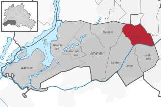
Steglitz (Steglitz)
- locality of Berlin
Steglitz is a district located in Berlin, Germany, and it offers several opportunities for outdoor activities, including hiking. While Steglitz itself might not have extensive hiking trails like some of the more rural areas surrounding Berlin, there are still some pleasant parks and natural areas where you can enjoy walking and light hiking. Here are a few options:
-
Grunewald Forest: Located nearby, this expansive forest offers numerous trails for hiking. The area is characterized by its beautiful landscapes, serene lakes, and various routes that cater to different skill levels. It’s a great place for more extended hikes.
-
Botanical Garden: While not a hike in the traditional sense, the Berlin Botanical Garden in Steglitz offers a lovely walking experience. You can stroll through beautifully curated plant collections and gardens.
-
Schlosspark Steglitz: This park surrounds the old Steglitz Palace and provides a peaceful setting for a leisurely walk. The landscape is scenic and can be a nice spot for shorter hikes or nature walks.
-
Südfriedhof: The South Cemetery is a historic site with beautiful pathways, making it an unusual yet serene place to explore.
For those looking for more extensive hiking options, you may consider venturing outside of Berlin to areas like the Müritz National Park or the Harz Mountains, which provide more rugged trails and breathtaking views.
When hiking in and around Berlin, remember to stay hydrated, wear appropriate footwear, and respect the nature around you. Enjoy your hikes!
- Country:

- Postal Code: 12169; 12167; 12165; 12163; 12161; 12157
- Coordinates: 52° 28' 0" N, 13° 20' 0" E


- GPS tracks (wikiloc): [Link]
- AboveSeaLevel: 51 м m
- Area: 6.79 sq km
- Population: 73463
- Wikipedia en: wiki(en)
- Wikipedia: wiki(de)
- Wikidata storage: Wikidata: Q700211
- Wikipedia Commons Gallery: [Link]
- Wikipedia Commons Category: [Link]
- Wikipedia Commons Maps Category: [Link]
- Freebase ID: [/m/0d9k13]
- GeoNames ID: Alt: [2829109]
- VIAF ID: Alt: [312799553]
- GND ID: Alt: [4112721-3]
- archINFORM location ID: [3624]
- Library of Congress authority ID: Alt: [n80137576]
Shares border with regions:

Lichterfelde
- locality of Berlin, Germany
Lichterfelde is a district in the southwestern part of Berlin, known for its residential areas, parks, and greenery. While it may not be a traditional hiking destination like larger natural reserves or mountainous regions, there are still opportunities for enjoyable walking and hiking experiences in and around this area....
- Country:

- Postal Code: 14167; 12209; 12207; 12205; 12203
- Coordinates: 52° 26' 0" N, 13° 19' 0" E


- GPS tracks (wikiloc): [Link]
- AboveSeaLevel: 47 м m
- Area: 18.22 sq km
- Population: 81831


Berlin-Schöneberg
- locality of Berlin, Germany
Hiking in Schöneberg, a district in Berlin, Germany, offers a unique blend of urban exploration and access to green spaces. While Schöneberg is primarily known for its vibrant city life, you can find several parks and natural areas that provide great opportunities for hiking and outdoor activities....
- Country:

- Postal Code: 12169; 12161; 12159; 12157; 10829; 10827; 10825; 10823; 10789; 10787; 10783; 10781; 10779; 10777
- Coordinates: 52° 28' 59" N, 13° 20' 59" E


- GPS tracks (wikiloc): [Link]
- AboveSeaLevel: 47 м m
- Area: 10.61 sq km
- Population: 118368


Tempelhof
- locality of Berlin
Tempelhof, a district in Berlin, Germany, is known more for its urban atmosphere than for traditional hiking trails. However, it has unique outdoor spaces that can offer enjoyable walking and exploring experiences for those looking for a more urban hike....
- Country:

- Postal Code: 12279; 12099; 12109; 12105; 12103; 12101
- Coordinates: 52° 28' 0" N, 13° 23' 0" E


- GPS tracks (wikiloc): [Link]
- AboveSeaLevel: 47 м m
- Area: 12.2 sq km
- Population: 59728


Lankwitz
- locality of Berlin
Lankwitz is a district in the southwestern part of Berlin, Germany. While it may not be known for traditional hiking in the way that larger nature reserves or mountain regions are, there are still opportunities for enjoyable walks and hikes in and around the area....
- Country:

- Postal Code: 12249; 12247
- Coordinates: 52° 26' 0" N, 13° 21' 0" E


- GPS tracks (wikiloc): [Link]
- AboveSeaLevel: 43 м m
- Area: 6.99 sq km
- Population: 41955


Friedenau
- locality of Berlin, Germany
Friedenau is a neighborhood in Berlin, Germany, known primarily for its residential areas, parks, and historical architecture rather than for traditional hiking trails. However, if you're interested in nearby walking or hiking opportunities, here are some options you can explore:...
- Country:

- Postal Code: 14197; 12161; 12159; 12157; 10827
- Coordinates: 52° 28' 20" N, 13° 19' 40" E


- GPS tracks (wikiloc): [Link]
- AboveSeaLevel: 44 м m
- Area: 1.65 sq km
- Population: 27499


Dahlem
- locality of Berlin
Dahlem, a district in the southwestern part of Berlin, is known for its greenery and is home to several parks and nature reserves that can provide a pleasant hiking experience. Though it may not be as rugged or extensive as hiking in mountainous regions, there are still several opportunities for enjoying nature and walking in this area....
- Country:

- Postal Code: 14195; 14169
- Coordinates: 52° 27' 29" N, 13° 17' 15" E


- GPS tracks (wikiloc): [Link]
- AboveSeaLevel: 54 м m
- Area: 8.39 sq km
- Population: 15973

