%20banner%20Gro%C3%9Fer%20Wannsee.jpg)
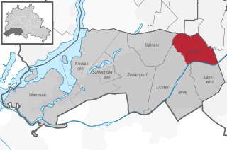
Steglitz-Zehlendorf (Steglitz-Zehlendorf)
- borough of Berlin, Germany
 Hiking in Steglitz-Zehlendorf
Steglitz-Zehlendorf, a district in southwest Berlin, offers a lovely blend of urban and natural landscapes, making it a unique hiking destination. Here are some key points to consider when hiking in this area:
Trails and Parks
-
Grunewald Forest: One of the largest green spaces in the vicinity, Grunewald is perfect for hiking. There are numerous trails of varying difficulty, winding through the forest and alongside the scenic Wannsee lake. The paths are well-marked, making it easy to explore.
-
Havel River Trails: The Havel River provides picturesque paths along its banks. You can enjoy leisurely hikes while taking in the sights of the river and the surrounding nature.
-
Schlachtensee and Krumme Lanke: These two lakes are surrounded by well-maintained walking paths. A circuit around either lake provides a gentle hike while enjoying views of the water and local wildlife. Both lakes are popular spots for picnicking, so they can be a great place to relax after your hike.
Points of Interest
- Teufelsberg: An artificial hill made from WWII debris, it offers stunning views of Berlin. The hike to the top can be a bit challenging, but the panoramic view is worth the effort.
- Botanical Garden: While not a hiking trail per se, the gardens offer beautiful pathways and a serene environment, perfect for a leisurely stroll amidst diverse plant species.
Hiking Recommendations
- Duration and Difficulty: Trails vary from easy lakeside walks to more challenging forest hikes. Ensure you choose a trail that matches your fitness level and hiking experience.
- Best Time to Hike: Late spring through early autumn is ideal when the weather is generally mild. Early mornings or late afternoons can offer a cooler experience and fewer crowds.
- Safety and Preparation: Always carry water, snacks, and a basic first-aid kit. Make sure to wear appropriate footwear to navigate various terrains.
Transportation
Steglitz-Zehlendorf is well-connected by public transportation, making it easy to access hiking spots from other areas in Berlin. The S-Bahn and U-Bahn services can take you close to many of the natural attractions.
Conclusion
Hiking in Steglitz-Zehlendorf is a delightful way to explore Berlin's natural beauty while enjoying the tranquility of the outdoors. Whether you're looking for a peaceful lake walk or an invigorating forest hike, this district provides a variety of options for all outdoor enthusiasts. Make sure to embrace the opportunities for nature photography and leisurely observation of local fauna!
- Country:

- Coordinates: 52° 26' 0" N, 13° 15' 0" E


- GPS tracks (wikiloc): [Link]
- Area: 103 sq km
- Web site: http://www.berlin.de/ba-steglitz-zehlendorf
- Wikipedia en: wiki(en)
- Wikipedia: wiki(de)
- Wikidata storage: Wikidata: Q158064
- Wikipedia Commons Gallery: [Link]
- Wikipedia Commons Category: [Link]
- Freebase ID: [/m/022nbn]
- OSM relation ID: [55734]
- archINFORM location ID: [43200]
- TGN ID: [7032550]
Includes regions:


Lichterfelde
- locality of Berlin, Germany
Hiking in Lichterfelde
Lichterfelde is a district in the southwestern part of Berlin, known for its residential areas, parks, and greenery. While it may not be a traditional hiking destination like larger natural reserves or mountainous regions, there are still opportunities for enjoyable walking and hiking experiences in and around this area....
- Country:
- Postal Code: 14167; 12209; 12207; 12205; 12203
- Coordinates: 52° 26' 0" N, 13° 19' 0" E
- GPS tracks (wikiloc): [Link]
- AboveSeaLevel: 47 м m
- Area: 18.22 sq km
- Population: 81831


Wannsee
- locality of Berlin
Hiking in Wannsee
Wannsee, located in the southwestern part of Berlin, is known for its scenic landscapes, beautiful lake views, and accessible trails, making it a popular destination for hiking and outdoor activities. Here are some highlights you might enjoy while hiking in the Wannsee area:...
- Country:
- Postal Code: 14109
- Coordinates: 52° 25' 0" N, 13° 9' 0" E
- GPS tracks (wikiloc): [Link]
- AboveSeaLevel: 40 м m
- Area: 23.68 sq km
- Population: 9719


Zehlendorf
- locality of Berlin
Hiking in Zehlendorf
Zehlendorf, located in the southwestern part of Berlin, is known for its beautiful natural surroundings, making it a great spot for hiking enthusiasts. Here are some key aspects to consider when planning a hiking trip in this area:...
- Country:
- Postal Code: 14169; 14167; 14165; 14163
- Coordinates: 52° 26' 2" N, 13° 15' 32" E
- GPS tracks (wikiloc): [Link]
- Area: 18.83 sq km
- Population: 58589


Nikolassee
- locality of Berlin
Hiking in Nikolassee
Nikolassee is a charming neighborhood located in the southwestern part of Berlin, Germany. It is known for its picturesque landscapes, including lakes, forests, and serene residential areas, making it a great destination for hiking enthusiasts....
- Country:
- Postal Code: 14193; 14163; 14129
- Coordinates: 52° 26' 0" N, 13° 12' 0" E
- GPS tracks (wikiloc): [Link]
- AboveSeaLevel: 42 м m
- Area: 19.61 sq km
- Population: 15864


Lankwitz
- locality of Berlin
Hiking in Lankwitz
Lankwitz is a district in the southwestern part of Berlin, Germany. While it may not be known for traditional hiking in the way that larger nature reserves or mountain regions are, there are still opportunities for enjoyable walks and hikes in and around the area....
- Country:
- Postal Code: 12249; 12247
- Coordinates: 52° 26' 0" N, 13° 21' 0" E
- GPS tracks (wikiloc): [Link]
- AboveSeaLevel: 43 м m
- Area: 6.99 sq km
- Population: 41955

Steglitz
- locality of Berlin
Hiking in Steglitz
Steglitz is a district located in Berlin, Germany, and it offers several opportunities for outdoor activities, including hiking. While Steglitz itself might not have extensive hiking trails like some of the more rural areas surrounding Berlin, there are still some pleasant parks and natural areas where you can enjoy walking and light hiking. Here are a few options:...
- Country:
- Postal Code: 12169; 12167; 12165; 12163; 12161; 12157
- Coordinates: 52° 28' 0" N, 13° 20' 0" E
- GPS tracks (wikiloc): [Link]
- AboveSeaLevel: 51 м m
- Area: 6.79 sq km
- Population: 73463


Dahlem
- locality of Berlin
Hiking in Dahlem
Dahlem, a district in the southwestern part of Berlin, is known for its greenery and is home to several parks and nature reserves that can provide a pleasant hiking experience. Though it may not be as rugged or extensive as hiking in mountainous regions, there are still several opportunities for enjoying nature and walking in this area....
- Country:
- Postal Code: 14195; 14169
- Coordinates: 52° 27' 29" N, 13° 17' 15" E
- GPS tracks (wikiloc): [Link]
- AboveSeaLevel: 54 м m
- Area: 8.39 sq km
- Population: 15973
Shares border with regions:

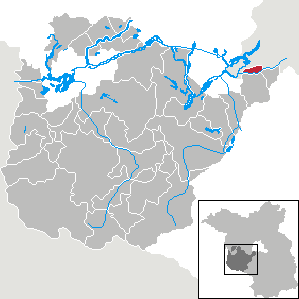
Kleinmachnow
- municipality in Brandenburg, Germany
Hiking in Kleinmachnow
Kleinmachnow, located near Berlin, Germany, offers a variety of hiking opportunities amidst its picturesque landscapes. The area is characterized by its lush forests, tranquil lakes, and diverse wildlife, making it an attractive spot for outdoor enthusiasts....
- Country:
- Postal Code: 14532
- Local Dialing Code: 033203
- Licence Plate Code: PM
- Coordinates: 52° 24' 13" N, 13° 13' 13" E
- GPS tracks (wikiloc): [Link]
- AboveSeaLevel: 45 м m
- Area: 11.91 sq km
- Population: 20562
- Web site: [Link]


Spandau
- borough of Berlin, Germany
Hiking in Spandau
Spandau, located in the western part of Berlin, Germany, is an area rich in history and natural beauty, making it a great spot for hiking enthusiasts. While Spandau is more urbanized than many rural hiking areas, there are several parks and natural reserves that offer opportunities for hiking and enjoying the outdoors....
- Country:
- Postal Code: 14089; 14052; 13629; 13599; 13597; 13595; 13593; 13591; 13589; 13587; 13585; 13583; 13581
- Coordinates: 52° 33' 0" N, 13° 12' 0" E
- GPS tracks (wikiloc): [Link]
- Area: 91.878 sq km
- Population: 231120
- Web site: [Link]

Charlottenburg-Wilmersdorf
- borough of Berlin, Germany
Hiking in Charlottenburg-Wilmersdorf
Charlottenburg-Wilmersdorf is a district in Berlin that, while primarily urban, offers some enjoyable opportunities for hiking and outdoor activities. Here are a few highlights and tips for hiking in and around the area:...
- Country:
- Coordinates: 52° 30' 0" N, 13° 17' 0" E
- GPS tracks (wikiloc): [Link]
- Area: 64.7 sq km
- Population: 334351
- Web site: [Link]


Tempelhof-Schöneberg
- borough of Berlin, Germany
Hiking in Tempelhof-Schöneberg
Tempelhof-Schöneberg is a unique district in Berlin, known more for its urban environment than traditional hiking trails. However, it does offer opportunities for outdoor activities and scenic walks. Here are some highlights for exploring the area on foot:...
- Country:
- Coordinates: 52° 28' 0" N, 13° 23' 0" E
- GPS tracks (wikiloc): [Link]
- Area: 531 sq km
- Web site: [Link]