Menetou-Râtel (Menetou-Râtel)

- commune in Cher, France
- Country:

- Postal Code: 18300
- Coordinates: 47° 21' 4" N, 2° 45' 21" E


- GPS tracks (wikiloc): [Link]
- Area: 28.01 sq km
- Population: 492
- Wikipedia en: wiki(en)
- Wikipedia: wiki(fr)
- Wikidata storage: Wikidata: Q1173547
- Wikipedia Commons Category: [Link]
- Freebase ID: [/m/03mfd96]
- GeoNames ID: Alt: [6428220]
- SIREN number: [211801444]
- BnF ID: [152494903]
- INSEE municipality code: 18144
Shares border with regions:


Bué
- commune in Cher, France
- Country:
- Postal Code: 18300
- Coordinates: 47° 18' 35" N, 2° 47' 35" E
- GPS tracks (wikiloc): [Link]
- Area: 6.3 sq km
- Population: 307

Crézancy-en-Sancerre
- commune in Cher, France
- Country:
- Postal Code: 18300
- Coordinates: 47° 18' 19" N, 2° 44' 38" E
- GPS tracks (wikiloc): [Link]
- AboveSeaLevel: 284 м m
- Area: 18.92 sq km
- Population: 475


Subligny
- commune in Cher, France
- Country:
- Postal Code: 18260
- Coordinates: 47° 24' 13" N, 2° 45' 17" E
- GPS tracks (wikiloc): [Link]
- Area: 17.26 sq km
- Population: 344
Sens-Beaujeu
- commune in Cher, France
- Country:
- Postal Code: 18300
- Coordinates: 47° 19' 36" N, 2° 42' 29" E
- GPS tracks (wikiloc): [Link]
- Area: 21.54 sq km
- Population: 400


Verdigny
- commune in Cher, France
- Country:
- Postal Code: 18300
- Coordinates: 47° 20' 49" N, 2° 48' 30" E
- GPS tracks (wikiloc): [Link]
- Area: 4.99 sq km
- Population: 315


Jars
- commune in Cher, France
- Country:
- Postal Code: 18260
- Coordinates: 47° 23' 45" N, 2° 40' 58" E
- GPS tracks (wikiloc): [Link]
- Area: 37.34 sq km
- Population: 516

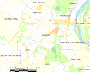
Sancerre
- commune in Cher, France
- Country:
- Postal Code: 18300
- Coordinates: 47° 19' 52" N, 2° 50' 20" E
- GPS tracks (wikiloc): [Link]
- Area: 16.27 sq km
- Population: 1425
- Web site: [Link]


Sury-en-Vaux
- commune in Cher, France
- Country:
- Postal Code: 18300
- Coordinates: 47° 22' 5" N, 2° 48' 17" E
- GPS tracks (wikiloc): [Link]
- Area: 15.82 sq km
- Population: 713
- Web site: [Link]