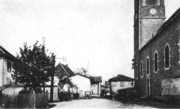
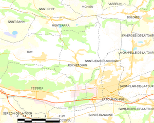
Saint-Jean-de-Soudain (Saint-Jean-de-Soudain)

- commune in Isère, France
 Hiking in Saint-Jean-de-Soudain
Saint-Jean-de-Soudain is a picturesque village located in the Isère department of the Auvergne-Rhône-Alpes region in southeastern France. It's an excellent base for hikers looking to explore the natural landscapes and mountainous terrain nearby.
Hiking Opportunities
-
Local Trails: The area surrounding Saint-Jean-de-Soudain features several hiking trails, from easy walks suitable for families to more challenging routes for experienced hikers. Trails often offer scenic views of the surrounding countryside and the nearby Chartreuse and Vercors mountains.
-
Chartreuse Massif: Just a short drive away, the Chartreuse Mountains offer a variety of trails that range from gentle slopes to steep ascents. Notable hikes include the paths leading to the Croix de Chamechaude, which is the highest peak in the massif.
-
Vercors Regional Natural Park: To the south of Saint-Jean-de-Soudain, the Vercors Park boasts stunning landscapes and diverse flora and fauna. It’s known for dramatic cliffs, deep gorges, and lush forests, with well-marked paths and a network of trails for all levels of hikers.
-
Lakes and Rivers: There are opportunities for shorter hikes around local lakes or alongside rivers, offering a combination of hiking and relaxing by the water.
Tips for Hiking
- Prepare Adequately: Check the weather conditions before heading out, as mountain weather can be unpredictable.
- Trail Maps: Bring a local trail map or download an app for navigation, as signs can sometimes be sparse in remote areas.
- Gear: Wear sturdy hiking boots and bring supplies such as water, snacks, a first-aid kit, and sun protection.
- Respect Nature: Stay on marked paths to help preserve the local ecosystem.
Summary
Hiking in and around Saint-Jean-de-Soudain offers an excellent mix of scenic beauty, diverse trails, and the chance to explore the stunning regions of the Alps. Whether you are a novice or an experienced hiker, you’ll find routes that suit your preferences and fitness levels. Enjoy your time in this beautiful part of France!
- Country:

- Postal Code: 38110
- Coordinates: 45° 34' 21" N, 5° 25' 44" E


- GPS tracks (wikiloc): [Link]
- Area: 7.48 sq km
- Population: 1572
- Web site: http://www.saintjeandesoudain.fr
- Wikipedia en: wiki(en)
- Wikipedia: wiki(fr)
- Wikidata storage: Wikidata: Q639765
- Wikipedia Commons Category: [Link]
- Freebase ID: [/m/03nvgxy]
- GeoNames ID: Alt: [6433353]
- SIREN number: [213804016]
- BnF ID: [15258211c]
- PACTOLS thesaurus ID: [pcrt6nq8LWhWVx]
- INSEE municipality code: 38401
Shares border with regions:


Cessieu
- commune in Isère, France
Hiking in Cessieu
Cessieu is a charming commune located in the Auvergne-Rhône-Alpes region of France, nestled between the Rhône River and the foothills of the Alps. Although it may not be as widely recognized as some other hiking destinations, it offers various opportunities for outdoor enthusiasts....
- Country:
- Postal Code: 38110
- Coordinates: 45° 34' 0" N, 5° 22' 36" E
- GPS tracks (wikiloc): [Link]
- Area: 14.35 sq km
- Population: 2886
- Web site: [Link]


La Chapelle-de-la-Tour
- commune in Isère, France
Hiking in La Chapelle-de-la-Tour
La Chapelle-de-la-Tour is a charming commune located in the Isère department in the Auvergne-Rhône-Alpes region of southeastern France. The area is known for its beautiful landscapes, making it an excellent spot for hiking enthusiasts. Here are some highlights to consider when hiking in and around La Chapelle-de-la-Tour:...
- Country:
- Postal Code: 38110
- Coordinates: 45° 35' 7" N, 5° 27' 47" E
- GPS tracks (wikiloc): [Link]
- Area: 9.04 sq km
- Population: 1757
- Web site: [Link]

Sainte-Blandine
- commune in Isère, France
Hiking in Sainte-Blandine
Sainte-Blandine, located in the Isère department of the Auvergne-Rhône-Alpes region in southeastern France, is a charming village surrounded by beautiful natural landscapes ideal for hiking enthusiasts. Here are some highlights and tips for hiking in the area:...
- Country:
- Postal Code: 38110
- Coordinates: 45° 32' 48" N, 5° 26' 26" E
- GPS tracks (wikiloc): [Link]
- Area: 9.21 sq km
- Population: 963

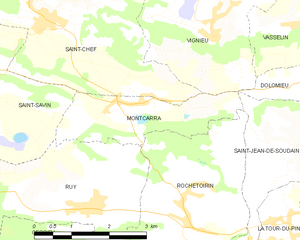
Montcarra
- commune in Isère, France
Hiking in Montcarra
Montcarra, located in the Isère department of southeastern France, is a beautiful area known for its scenic landscapes and outdoor activities. While it may not be as widely recognized as some of the larger national parks in the Alps, it offers a variety of hiking opportunities that can cater to different skill levels and preferences....
- Country:
- Postal Code: 38890
- Coordinates: 45° 36' 47" N, 5° 23' 29" E
- GPS tracks (wikiloc): [Link]
- Area: 4.9 sq km
- Population: 519
- Web site: [Link]

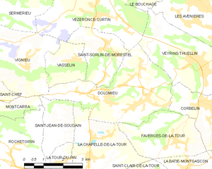
Dolomieu
- commune in Isère, France
Hiking in Dolomieu
Hiking in Dolomieu, Isère can be a wonderful experience, offering stunning landscapes and diverse trails. While Dolomieu is a small town, it is surrounded by natural beauty and is close to the Vercors and Chartreuse mountain ranges, which provide a variety of hiking opportunities....
- Country:
- Postal Code: 38110
- Coordinates: 45° 36' 39" N, 5° 29' 57" E
- GPS tracks (wikiloc): [Link]
- Area: 13.32 sq km
- Population: 3079
- Web site: [Link]

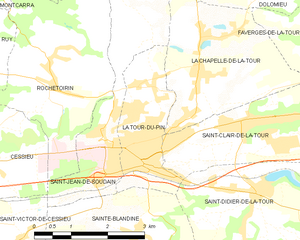
La Tour-du-Pin
- commune in Isère, France
Hiking in La Tour-du-Pin
La Tour-du-Pin is a charming town located in the Isère department of the Auvergne-Rhône-Alpes region in southeastern France. Its proximity to the French Alps and various natural parks makes it an excellent spot for hiking enthusiasts....
- Country:
- Postal Code: 38110
- Coordinates: 45° 33' 57" N, 5° 26' 42" E
- GPS tracks (wikiloc): [Link]
- Area: 4.77 sq km
- Population: 7970
- Web site: [Link]

Rochetoirin
- commune in Isère, France
Hiking in Rochetoirin
Rochetoirin, located in the Auvergne-Rhône-Alpes region of France, is a charming destination for hiking enthusiasts. Nestled near the foothills of the Chartreuse Mountains, the area offers a variety of natural landscapes, from rolling hills to picturesque forests, and a glimpse of local flora and fauna....
- Country:
- Postal Code: 38110
- Coordinates: 45° 34' 54" N, 5° 25' 5" E
- GPS tracks (wikiloc): [Link]
- Area: 10.62 sq km
- Population: 1115
- Web site: [Link]

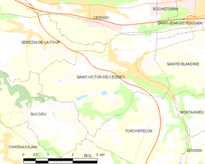
Saint-Victor-de-Cessieu
- commune in Isère, France
Hiking in Saint-Victor-de-Cessieu
Saint-Victor-de-Cessieu is a charming commune located in the Isère department of France, nestled near the beautiful landscape of the Rhône-Alpes region. The area is known for its picturesque views, rolling hills, and diverse flora and fauna, making it an appealing destination for hiking enthusiasts....
- Country:
- Postal Code: 38110
- Coordinates: 45° 32' 27" N, 5° 23' 29" E
- GPS tracks (wikiloc): [Link]
- Area: 12.22 sq km
- Population: 2209
- Web site: [Link]