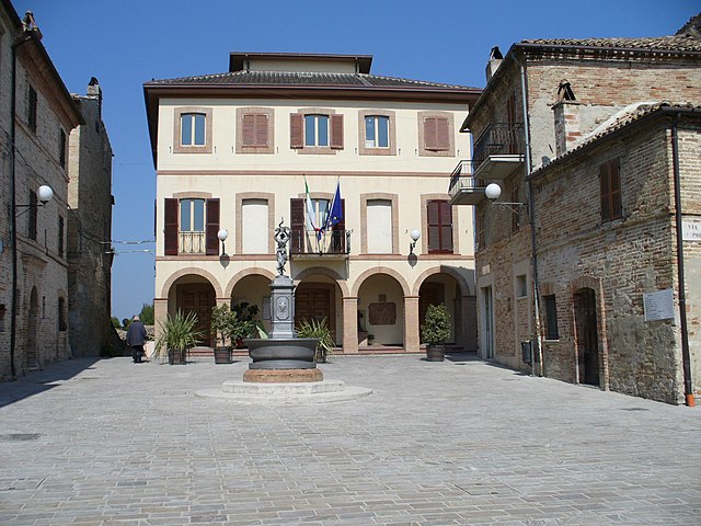
Montefiore dell'Aso (Montefiore dell'Aso)
.svg)
- Italian comune
 Hiking in Montefiore dell'Aso
Montefiore dell'Aso is a charming hilltop village located in the Marche region of Italy, known for its beautiful landscapes, historical architecture, and a rich cultural heritage. Hiking in and around Montefiore dell'Aso offers a unique blend of natural beauty and cultural exploration.
Hiking Trails
-
Vineyards and Olive Groves: Many trails lead you through the scenic vineyards and olive groves surrounding the village. You can enjoy stunning views of the rolling hills and, on clear days, even see the Adriatic Sea.
-
The Regional Park: Nearby is the Monti Sibillini National Park, where more challenging hikes can be found. This park offers well-marked trails that take you through diverse landscapes, including mountains, forests, and meadows.
-
Historic Walks: Some trails take you through the old town of Montefiore dell'Aso itself, with its narrow streets, ancient walls, and charming architecture. You can explore historical sites, such as the castle and various churches, while enjoying the hike.
-
Coastal Trails: If you're up for a longer adventure, you can hike towards the coast, reaching areas like Pedaso or San Benedetto del Tronto. These coastal trails offer breathtaking views of the Adriatic Sea.
Hiking Tips
-
Best Time to Hike: Spring (April to June) and fall (September to October) are ideal for hiking, as the temperatures are mild, and the scenery is vibrant.
-
Gear: Wear comfortable hiking shoes with good ankle support, and carry water, snacks, a map or GPS device, and sun protection.
-
Local Guides: Consider hiring a local guide for unique insights into the area's natural and cultural history.
-
Check Local Conditions: Always check trail conditions and weather forecasts before heading out, especially in mountainous areas.
Attractions and Stops
While hiking, take the opportunity to explore local wineries for tastings, enjoy traditional Marche cuisine at small trattorias, and engage with the local culture. Montefiore dell'Aso’s artistic heritage, including its frescoes and ceramics, makes for an enriching hiking experience.
Overall, hiking in Montefiore dell'Aso is not just about the physical activity; it’s also an opportunity to immerse yourself in Italy's natural beauty and rich culture. Enjoy your hike!
- Country:

- Postal Code: 63062
- Local Dialing Code: 0734
- Licence Plate Code: AP
- Coordinates: 43° 3' 6" N, 13° 45' 5" E


- GPS tracks (wikiloc): [Link]
- AboveSeaLevel: 412 м m
- Area: 28.21 sq km
- Population: 2053
- Web site: http://www.comune.montefioredellaso.ap.it/
- Wikipedia en: wiki(en)
- Wikipedia: wiki(it)
- Wikidata storage: Wikidata: Q56080
- Wikipedia Commons Gallery: [Link]
- Wikipedia Commons Category: [Link]
- Freebase ID: [/m/0gl86w]
- GeoNames ID: Alt: [6542085]
- VIAF ID: Alt: [134060179]
- OSM relation ID: [42289]
- UN/LOCODE: [ITMFD]
- Google Maps Customer ID: [3316138069463168057]
- ISTAT ID: 044036
- Italian cadastre code: F501
Shares border with regions:


Carassai
- Italian comune
Hiking in Carassai
Carassai, located in the Marche region of Italy, offers a unique hiking experience with its beautiful landscapes, rolling hills, and cultural heritage. While the town itself is relatively small, the surrounding area provides various trails that can cater to different skill levels....
- Country:
- Postal Code: 63063
- Local Dialing Code: 0734
- Licence Plate Code: AP
- Coordinates: 43° 1' 56" N, 13° 41' 1" E
- GPS tracks (wikiloc): [Link]
- AboveSeaLevel: 365 м m
- Area: 22.24 sq km
- Population: 1055
- Web site: [Link]
Massignano
- Italian comune
Hiking in Massignano
Massignano is a charming village located in the Marche region of Italy, known for its scenic landscapes and hiking opportunities. The area is characterized by rolling hills, vineyards, olive groves, and a beautiful coastline along the Adriatic Sea. Here are some key features and tips for hiking in and around Massignano:...
- Country:
- Postal Code: 63061
- Local Dialing Code: 0735
- Licence Plate Code: AP
- Coordinates: 43° 3' 3" N, 13° 47' 50" E
- GPS tracks (wikiloc): [Link]
- AboveSeaLevel: 255 м m
- Area: 16.3 sq km
- Population: 1640
- Web site: [Link]
Ripatransone
- Italian comune
Hiking in Ripatransone
Ripatransone, located in the Marche region of Italy, is a charming hilltop town known for its stunning landscapes, historic architecture, and scenic hiking opportunities. Here are some highlights of hiking in and around Ripatransone:...
- Country:
- Postal Code: 63065
- Local Dialing Code: 0735
- Licence Plate Code: AP
- Coordinates: 43° 0' 1" N, 13° 45' 45" E
- GPS tracks (wikiloc): [Link]
- AboveSeaLevel: 494 м m
- Area: 74.28 sq km
- Population: 4232
- Web site: [Link]
Campofilone
- Italian comune
Hiking in Campofilone
Campofilone is a charming town located in the province of Fermo in the Marche region of Italy. Known for its picturesque landscapes and traditional architecture, it offers some great opportunities for hiking enthusiasts who want to explore the natural beauty of the surrounding area....
- Country:
- Postal Code: 63828
- Local Dialing Code: 0734
- Licence Plate Code: FM
- Coordinates: 43° 4' 45" N, 13° 48' 52" E
- GPS tracks (wikiloc): [Link]
- AboveSeaLevel: 210 м m
- Area: 12.21 sq km
- Population: 1918
- Web site: [Link]


Lapedona
- Italian comune
Hiking in Lapedona
Lapedona is a charming village located in the Marche region of Italy, known for its picturesque landscapes and natural beauty, making it a great destination for hiking enthusiasts. Here are some key points to consider if you plan to hike in or around Lapedona:...
- Country:
- Postal Code: 63823
- Local Dialing Code: 0734
- Licence Plate Code: FM
- Coordinates: 43° 6' 35" N, 13° 46' 22" E
- GPS tracks (wikiloc): [Link]
- AboveSeaLevel: 264 м m
- Area: 14.93 sq km
- Population: 1189
- Web site: [Link]


Monterubbiano
- Italian comune
Hiking in Monterubbiano
Monterubbiano is a charming hilltop town located in the Marche region of Italy, known for its scenic views, medieval architecture, and rich cultural heritage. Hiking around Monterubbiano offers opportunities to explore beautiful landscapes, quaint countryside, and historical sites....
- Country:
- Postal Code: 63825
- Local Dialing Code: 0734
- Licence Plate Code: FM
- Coordinates: 43° 5' 7" N, 13° 43' 0" E
- GPS tracks (wikiloc): [Link]
- AboveSeaLevel: 463 м m
- Area: 32.24 sq km
- Population: 2164
- Web site: [Link]


Moresco
- Italian comune
Hiking in Moresco
Moresco is a charming hilltop village located in the Marche region of Italy, known for its scenic views and rich history. Hiking in and around Moresco can be a delightful experience, as the area offers varied landscapes, including hills, valleys, and the coastal scenery of the Adriatic Sea....
- Country:
- Postal Code: 63826
- Local Dialing Code: 0734
- Licence Plate Code: FM
- Coordinates: 43° 5' 9" N, 13° 43' 55" E
- GPS tracks (wikiloc): [Link]
- AboveSeaLevel: 405 м m
- Area: 6.35 sq km
- Population: 576
- Web site: [Link]


Petritoli
- Italian comune
Hiking in Petritoli
Petritoli is a charming small town located in the Marche region of Italy, known for its scenic landscapes and historical architecture. Its position on a hill offers stunning views of the surrounding countryside, making it an ideal base for hiking enthusiasts. Here are some key points about hiking in and around Petritoli:...
- Country:
- Postal Code: 63848
- Local Dialing Code: 0734
- Licence Plate Code: FM
- Coordinates: 43° 4' 2" N, 13° 39' 22" E
- GPS tracks (wikiloc): [Link]
- AboveSeaLevel: 358 м m
- Area: 24 sq km
- Population: 2297
- Web site: [Link]