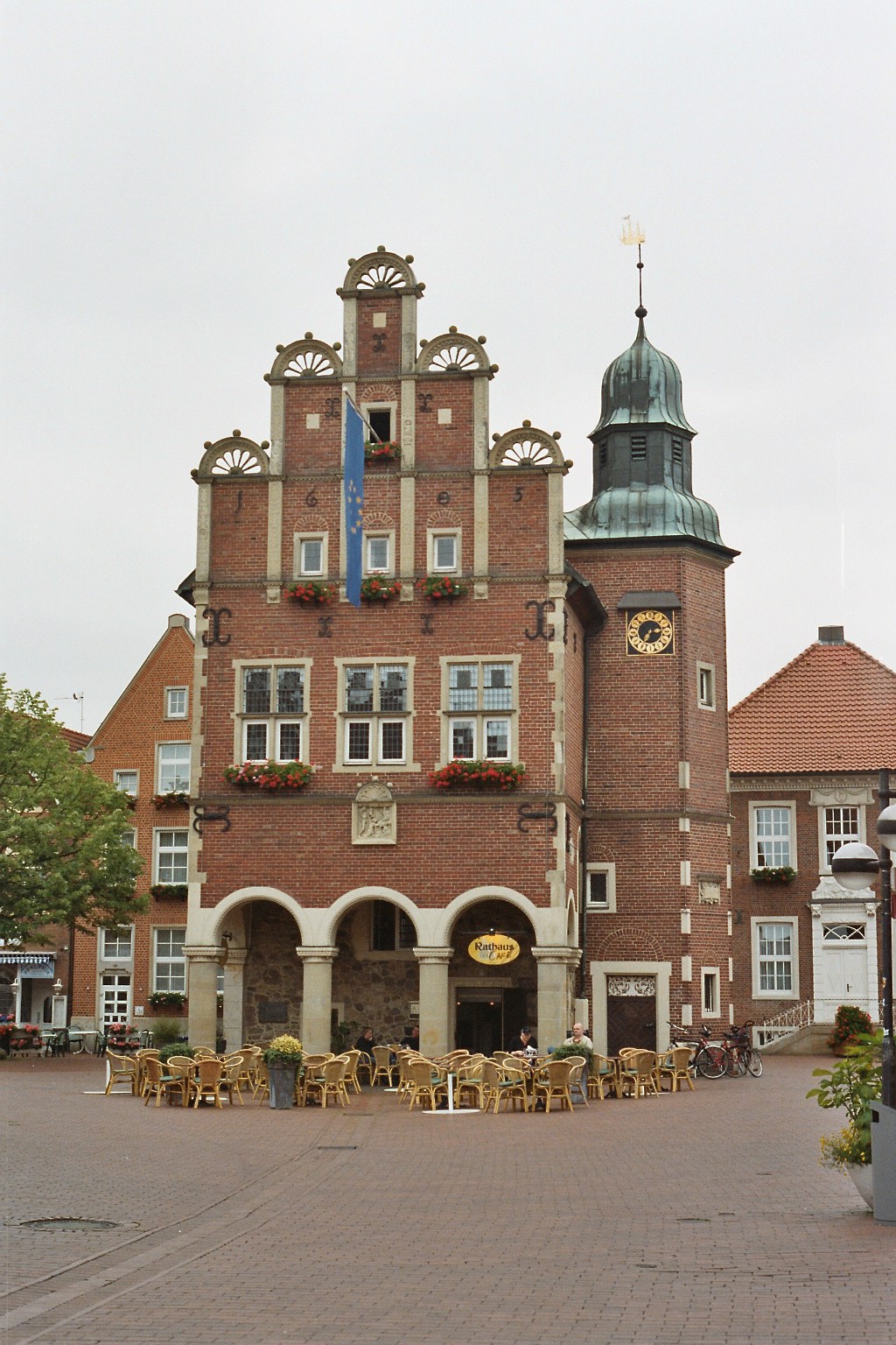
Osnabrück (Landkreis Osnabrück)
.svg)
- district in Lower Saxony, Germany
 Hiking in Osnabrück
Osnabrück district, located in Lower Saxony, Germany, offers a variety of hiking opportunities that cater to different skill levels and preferences. The region is characterized by its rolling hills, lush forests, and picturesque landscapes, making it an appealing destination for outdoor enthusiasts.
Key Hiking Areas in Osnabrück District:
-
Teutoburg Forest:
- This forest is famous for its dense woodlands and offers numerous trails suitable for hiking. The trails vary in difficulty, from easy walks suitable for families to more challenging routes for experienced hikers.
- The Hermannsweg is a popular long-distance hiking trail that runs along the ridge, providing stunning views and access to historical sites.
-
Wiehengebirge:
- Stretching from the Osnabrück district into the northern part of North Rhine-Westphalia, the Wiehengebirge offers hilly terrain and scenic vistas. It features a variety of hiking paths, including sections of the Peter-August-Brook-Trail.
- Nature lovers can enjoy diverse flora and fauna, especially in the nature reserves.
-
Münsterland Region:
- While part of the district is flatter, the Münsterland has well-managed cycling and walking paths, making it suitable for leisurely hikes. The paths often lead through charming villages, farmland, and beside picturesque lakes.
-
Burgen- und Schlösserweg:
- This trail connects several castles and historical sites in the area, allowing hikers to enjoy both nature and history.
Tips for Hiking in Osnabrück District:
-
Preparation: Always check the weather conditions before heading out and dress appropriately. Sturdy footwear is essential, particularly on hilly or uneven terrain.
-
Maps and Guides: Utilize local maps or hiking apps to navigate the trails. Many areas have well-marked paths, but having a guide can enhance the experience.
-
Hydration and Snacks: Carry enough water and snacks, particularly if you are planning a long hike. There may be limited facilities on the trails.
-
Respect Nature: Stay on marked paths, carry out what you bring in, and respect local wildlife and flora.
-
Local Information: Visit the local tourist information offices for maps, guided tours, and the latest updates on trail conditions.
Osnabrück district is an excellent place for both relaxed day hikes and more adventurous excursions. With its diverse landscapes and historical backdrop, it offers something special for every hiker. Enjoy your adventure!
- Country:

- Capital: Osnabrück
- Licence Plate Code: OS
- Coordinates: 52° 19' 48" N, 8° 10' 12" E


- GPS tracks (wikiloc): [Link]
- AboveSeaLevel: 57 м m
- Area: 2122.00 sq km
- Population: 354807
- Web site: http://www.landkreis-osnabrueck.de/
- Wikipedia en: wiki(en)
- Wikipedia: wiki(de)
- Wikidata storage: Wikidata: Q5940
- Wikipedia Commons Category: [Link]
- Freebase ID: [/m/013w74]
- GeoNames ID: Alt: [3221098]
- BnF ID: [127898011]
- VIAF ID: Alt: [141931063]
- OSM relation ID: [62673]
- GND ID: Alt: [4043979-3]
- archINFORM location ID: [2550]
- Library of Congress authority ID: Alt: [n83062915]
- TGN ID: [7076837]
- National Library of Israel ID: [000999755]
- NUTS code: [DE94E]
- BabelNet ID: [00742403n]
- German district key: 03459
Includes regions:


Georgsmarienhütte
- town in Osnabrück, Lower Saxony, Germany
Hiking in Georgsmarienhütte
Georgsmarienhütte is located in Lower Saxony, Germany, near the larger city of Osnabrück. The region offers beautiful natural landscapes, including hills, forests, and scenic views, making it suitable for various hiking activities. Here’s what you can expect when hiking in and around Georgsmarienhütte:...
- Country:
- Postal Code: 49124
- Local Dialing Code: 05401
- Licence Plate Code: OS
- Coordinates: 52° 12' 0" N, 8° 4' 0" E
- GPS tracks (wikiloc): [Link]
- AboveSeaLevel: 110 м m
- Area: 55 sq km
- Population: 31594
- Web site: [Link]


Bramsche
- town in Osnabrück, Lower Saxony, Germany
Hiking in Bramsche
Bramsche, located in Lower Saxony, Germany, is surrounded by beautiful landscapes that are ideal for hiking enthusiasts. The area features a mix of wooded regions, rolling hills, and charming rural scenery, making it a pleasant destination for both beginners and experienced hikers....
- Country:
- Postal Code: 49565
- Local Dialing Code: 05468; 05464; 05461
- Licence Plate Code: OS
- Coordinates: 52° 24' 32" N, 7° 58' 22" E
- GPS tracks (wikiloc): [Link]
- AboveSeaLevel: 48 м m
- Area: 183.32 sq km
- Population: 31001
- Web site: [Link]

Artland
- Samtgemeinde in Lower Saxony
Hiking in Artland
Artland is a beautiful region located in the northwest part of Lower Saxony, Germany, known for its picturesque landscapes and artistic heritage. While it may not be as well-known as some of Germany’s major hiking destinations, it offers unique trails that cater to different skill levels and interests. Here are some aspects to consider when hiking in Artland:...
- Country:
- Coordinates: 52° 40' 34" N, 7° 57' 26" E
- GPS tracks (wikiloc): [Link]
- Area: 189.32 sq km
- Population: 23107
- Web site: [Link]

Bersenbrück
- Samtgemeinde in Lower Saxony
Hiking in Bersenbrück
Bersenbrück, located in the Samtgemeinde Bersenbrück in Lower Saxony, Germany, offers a peaceful and picturesque setting for hiking enthusiasts. The region is characterized by its rural landscapes, forests, and charming villages, making it a great destination for both casual walkers and more serious hikers....
- Country:
- Coordinates: 52° 33' 19" N, 7° 56' 47" E
- GPS tracks (wikiloc): [Link]
- Area: 255.45 sq km
- Population: 29192
- Web site: [Link]


Melle
- city in the district of Osnabrück, Lower Saxony, Germany
Hiking in Melle
Melle, Germany, is a charming town situated in the Lower Saxony region, surrounded by beautiful landscapes that make it an excellent destination for hiking enthusiasts. The area offers a variety of trails that cater to different skill levels, from beginners to more experienced hikers....
- Country:
- Postal Code: 49325; 49324
- Local Dialing Code: 05429; 05428; 05427; 05422; 05226
- Licence Plate Code: OS
- Coordinates: 52° 12' 11" N, 8° 20' 10" E
- GPS tracks (wikiloc): [Link]
- AboveSeaLevel: 76 м m
- Area: 253.99 sq km
- Population: 46228
- Web site: [Link]
Shares border with regions:
Warendorf District
- district in North Rhine-Westphalia, Germany
Hiking in Warendorf District
Warendorf, located in the North Rhine-Westphalia region of Germany, is known for its picturesque landscapes, charming villages, and lush countryside, making it a delightful destination for hiking enthusiasts....
- Country:
- Licence Plate Code: WAF
- Coordinates: 51° 55' 12" N, 7° 55' 12" E
- GPS tracks (wikiloc): [Link]
- AboveSeaLevel: 65 м m
- Web site: [Link]


Osnabrück
- German city
Hiking in Osnabrück
Osnabrück, located in Lower Saxony, Germany, is a fantastic destination for hiking enthusiasts. The region is characterized by its varied landscapes, including forests, hills, and meadows, making it ideal for both casual walkers and more experienced hikers....
- Country:
- Postal Code: 49074–49090
- Local Dialing Code: 05407; 05406; 05402; 0541
- Licence Plate Code: OS
- Coordinates: 52° 16' 44" N, 8° 2' 35" E
- GPS tracks (wikiloc): [Link]
- AboveSeaLevel: 63 м m
- Area: 119.8 sq km
- Population: 164070
- Web site: [Link]

Emsland
- district in Lower Saxony, Germany
Hiking in Emsland
Emsland, located in Lower Saxony, Germany, is a fantastic region for hiking enthusiasts. Known for its wide-open landscapes and rich natural beauty, Emsland offers a variety of trails that cater to hikers of all levels....
- Country:
- Capital: Meppen
- Licence Plate Code: EL
- Coordinates: 52° 40' 12" N, 7° 15' 0" E
- GPS tracks (wikiloc): [Link]
- AboveSeaLevel: 25 м m
- Area: 2882.07 sq km
- Population: 321391
- Web site: [Link]


Vechta
- district in Lower Saxony, Germany
Hiking in Vechta
Vechta is a district located in Lower Saxony, Germany, known for its picturesque landscapes and rural charm. While it may not be as mountainous as other regions in Germany, it offers several opportunities for hiking, especially for those who enjoy gentle walks through nature....
- Country:
- Licence Plate Code: VEC
- Coordinates: 52° 40' 12" N, 8° 15' 0" E
- GPS tracks (wikiloc): [Link]
- AboveSeaLevel: 27 м m
- Area: 813.00 sq km
- Population: 139671
- Web site: [Link]


Cloppenburg
- district in Lower Saxony, Germany
Hiking in Cloppenburg
Cloppenburg district, located in Lower Saxony, Germany, offers a variety of picturesque landscapes and natural beauty, making it a great destination for hiking enthusiasts. Here are some highlights and tips for hiking in the region:...
- Country:
- Capital: Cloppenburg
- Licence Plate Code: CLP
- Coordinates: 52° 49' 48" N, 8° 0' 0" E
- GPS tracks (wikiloc): [Link]
- AboveSeaLevel: 27 м m
- Area: 1418.00 sq km
- Population: 165930
- Web site: [Link]


Diepholz
- district in Lower Saxony, Germany
Hiking in Diepholz
Diepholz is a district located in Lower Saxony, Germany, known for its scenic landscapes and outdoor recreational opportunities, including hiking. Here are some insights about hiking in and around Diepholz:...
- Country:
- Licence Plate Code: SY; DH
- Coordinates: 52° 40' 12" N, 8° 34' 48" E
- GPS tracks (wikiloc): [Link]
- AboveSeaLevel: 52 м m
- Area: 1987.00 sq km
- Population: 209671
- Web site: [Link]


Steinfurt
- German district of North Rhine-Westphalia
Hiking in Steinfurt
Hiking in the Steinfurt district, located in North Rhine-Westphalia, Germany, offers a variety of scenic trails and natural landscapes that are ideal for outdoor enthusiasts. The region is characterized by its rolling hills, woodlands, and charming villages, making it a great place for hiking and exploring nature....
- Country:
- Licence Plate Code: ST
- Coordinates: 52° 10' 12" N, 7° 40' 12" E
- GPS tracks (wikiloc): [Link]
- AboveSeaLevel: 42 м m
- Area: 1795.76 sq km
- Web site: [Link]

Gütersloh
- district of North Rhine-Westphalia
Hiking in Gütersloh
Gütersloh district in North Rhine-Westphalia, Germany, offers a variety of hiking opportunities set against a picturesque backdrop of nature and charming landscapes. Here are some highlights for hiking in this area:...
- Country:
- Licence Plate Code: GT
- Coordinates: 51° 55' 0" N, 8° 20' 0" E
- GPS tracks (wikiloc): [Link]
- AboveSeaLevel: 70 м m
- Web site: [Link]
Herford
- German district of North Rhine-Westphalia
Hiking in Herford
Herford district, located in North Rhine-Westphalia, Germany, offers a variety of hiking opportunities amid beautiful landscapes, charming towns, and scenic nature trails. Here are some highlights that you can expect when hiking in this region:...
- Country:
- Licence Plate Code: HF
- Coordinates: 52° 10' 0" N, 8° 35' 0" E
- GPS tracks (wikiloc): [Link]
- AboveSeaLevel: 59 м m
- Web site: [Link]


Minden-Lübbecke District
- district in North Rhine-Westphalia, Germany
Hiking in Minden-Lübbecke District
Minden-Lübbecke is a beautiful district in North Rhine-Westphalia, Germany, known for its picturesque landscapes, diverse flora and fauna, and numerous hiking opportunities. Here are some highlights and tips for hiking in the area:...
- Country:
- Licence Plate Code: MI
- Coordinates: 52° 23' 57" N, 8° 43' 4" E
- GPS tracks (wikiloc): [Link]
- AboveSeaLevel: 58 м m
- Area: 1051.97 sq km
- Web site: [Link]