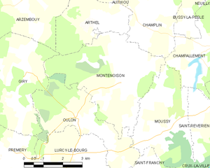
Oulon (Oulon)

- commune in Nièvre, France
- Country:

- Postal Code: 58700
- Coordinates: 47° 11' 57" N, 3° 23' 53" E


- GPS tracks (wikiloc): [Link]
- Area: 10.99 sq km
- Population: 67
- Wikipedia en: wiki(en)
- Wikipedia: wiki(fr)
- Wikidata storage: Wikidata: Q46538
- Wikipedia Commons Category: [Link]
- Freebase ID: [/m/03qfdyq]
- GeoNames ID: Alt: [6438043]
- SIREN number: [215802034]
- BnF ID: [15266468m]
- INSEE municipality code: 58203
Shares border with regions:
Saint-Franchy
- commune in Nièvre, France
- Country:
- Postal Code: 58330
- Coordinates: 47° 8' 22" N, 3° 27' 40" E
- GPS tracks (wikiloc): [Link]
- Area: 18.63 sq km
- Population: 74


Prémery
- commune in Nièvre, France
- Country:
- Postal Code: 58700
- Coordinates: 47° 10' 28" N, 3° 19' 51" E
- GPS tracks (wikiloc): [Link]
- Area: 45.62 sq km
- Population: 1868


Moussy
- commune in Nièvre, France
- Country:
- Postal Code: 58700
- Coordinates: 47° 11' 32" N, 3° 27' 13" E
- GPS tracks (wikiloc): [Link]
- Area: 11.97 sq km
- Population: 107

Montenoison
- commune in Nièvre, France
- Country:
- Postal Code: 58700
- Coordinates: 47° 12' 56" N, 3° 25' 37" E
- GPS tracks (wikiloc): [Link]
- Area: 16.73 sq km
- Population: 123

Giry
- commune in Nièvre, France
- Country:
- Postal Code: 58700
- Coordinates: 47° 13' 14" N, 3° 21' 53" E
- GPS tracks (wikiloc): [Link]
- Area: 23.78 sq km
- Population: 204


Lurcy-le-Bourg
- commune in Nièvre, France
- Country:
- Postal Code: 58700
- Coordinates: 47° 9' 40" N, 3° 23' 12" E
- GPS tracks (wikiloc): [Link]
- Area: 22.58 sq km
- Population: 300