Pommiers (Pommiers)

- commune in Loire, France
- Country:

- Postal Code: 42260
- Coordinates: 45° 49' 45" N, 4° 3' 55" E


- GPS tracks (wikiloc): [Link]
- Area: 23.84 sq km
- Population: 362
- Web site: http://www.pommiers.fr/
- Wikipedia en: wiki(en)
- Wikipedia: wiki(fr)
- Wikidata storage: Wikidata: Q670321
- Wikipedia Commons Category: [Link]
- Freebase ID: [/m/03nwbj5]
- Freebase ID: [/m/03nwbj5]
- GeoNames ID: Alt: [6614594]
- GeoNames ID: Alt: [6614594]
- SIREN number: [214201733]
- SIREN number: [214201733]
- BnF ID: [15259741x]
- BnF ID: [15259741x]
- Library of Congress authority ID: Alt: [no2012131218]
- Library of Congress authority ID: Alt: [no2012131218]
- INSEE municipality code: 42173
- INSEE municipality code: 42173
Shares border with regions:
Amions
- commune in Loire, France
- Country:
- Postal Code: 42260
- Coordinates: 45° 52' 41" N, 4° 2' 2" E
- GPS tracks (wikiloc): [Link]
- Area: 17.01 sq km
- Population: 288
- Web site: [Link]


Bussy-Albieux
- commune in Loire, France
- Country:
- Postal Code: 42260
- Coordinates: 45° 47' 35" N, 4° 2' 1" E
- GPS tracks (wikiloc): [Link]
- Area: 19.65 sq km
- Population: 535
- Web site: [Link]


Saint-Germain-Laval
- commune in Loire, France
- Country:
- Postal Code: 42260
- Coordinates: 45° 49' 49" N, 4° 0' 45" E
- GPS tracks (wikiloc): [Link]
- Area: 17.08 sq km
- Population: 1648
- Web site: [Link]

Nervieux
- commune in Loire, France
- Country:
- Postal Code: 42510
- Coordinates: 45° 48' 19" N, 4° 9' 17" E
- GPS tracks (wikiloc): [Link]
- Area: 19.44 sq km
- Population: 976
- Web site: [Link]

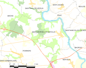
Saint-Georges-de-Baroille
- commune in Loire, France
- Country:
- Postal Code: 42510
- Coordinates: 45° 50' 59" N, 4° 7' 52" E
- GPS tracks (wikiloc): [Link]
- Area: 15.24 sq km
- Population: 404
- Web site: [Link]


Sainte-Foy-Saint-Sulpice
- commune in Loire, France
- Country:
- Postal Code: 42110
- Coordinates: 45° 46' 8" N, 4° 7' 45" E
- GPS tracks (wikiloc): [Link]
- Area: 29.12 sq km
- Population: 520
- Web site: [Link]