Saint-Pierre-les-Bois (Saint-Pierre-les-Bois)

- commune in Cher, France
- Country:

- Postal Code: 18170
- Coordinates: 46° 39' 52" N, 2° 16' 44" E


- GPS tracks (wikiloc): [Link]
- Area: 20.38 sq km
- Population: 296
- Wikipedia en: wiki(en)
- Wikipedia: wiki(fr)
- Wikidata storage: Wikidata: Q1172244
- Wikipedia Commons Category: [Link]
- Freebase ID: [/m/03mff0y]
- GeoNames ID: Alt: [6428288]
- SIREN number: [211802301]
- BnF ID: [15249576t]
- INSEE municipality code: 18230
Shares border with regions:


Le Châtelet
- commune in Cher, France
- Country:
- Postal Code: 18170
- Coordinates: 46° 38' 30" N, 2° 16' 59" E
- GPS tracks (wikiloc): [Link]
- Area: 32.8 sq km
- Population: 1041


Ardenais
- commune in Cher, France
- Country:
- Postal Code: 18170
- Coordinates: 46° 38' 50" N, 2° 21' 33" E
- GPS tracks (wikiloc): [Link]
- Area: 17.55 sq km
- Population: 207


Morlac
- commune in Cher, France
- Country:
- Postal Code: 18170
- Coordinates: 46° 43' 9" N, 2° 18' 30" E
- GPS tracks (wikiloc): [Link]
- Area: 32.38 sq km
- Population: 328


Maisonnais
- commune in Cher, France
- Country:
- Postal Code: 18170
- Coordinates: 46° 38' 24" N, 2° 12' 56" E
- GPS tracks (wikiloc): [Link]
- Area: 26.95 sq km
- Population: 238


Marçais
- commune in Cher, France
- Country:
- Postal Code: 18170
- Coordinates: 46° 41' 49" N, 2° 22' 14" E
- GPS tracks (wikiloc): [Link]
- Area: 29.03 sq km
- Population: 288

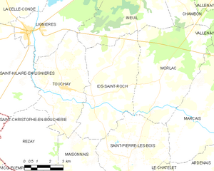
Ids-Saint-Roch
- commune in Cher, France
- Country:
- Postal Code: 18170
- Coordinates: 46° 42' 26" N, 2° 14' 27" E
- GPS tracks (wikiloc): [Link]
- Area: 27.83 sq km
- Population: 315