Wädenswil (Wädenswil)
- municipality in the canton of Zürich, Switzerland
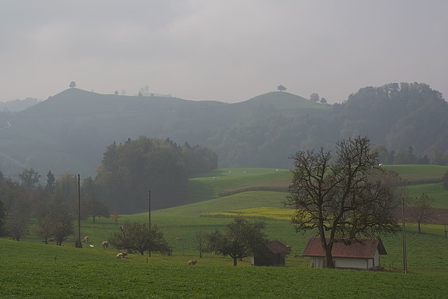
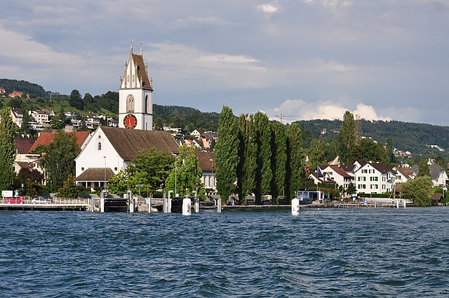
Wädenswil, located on the shores of Lake Zurich in Switzerland, offers beautiful hiking trails that suit various skill levels and provide stunning views of both the lake and the surrounding mountains. Here are some highlights and popular trails in and around Wädenswil:
Scenic Trails
-
Zürichsee Trail: This trail runs along the shores of Lake Zurich and offers picturesque views of the lake, with Wädenswil serving as one of the starting points. You can follow the path south towards places like Rüschlikon or up north towards Zürich.
-
Uetliberg Mountain: While Uetliberg is a bit further afield, it’s easily accessible from Wädenswil. The hike to the summit provides panoramic views of the city of Zurich and the Alps. The trail is well-marked and can be tackled by hikers of different levels.
-
Forest and Vineyards: Wädenswil is surrounded by vineyards and has several routes through scenic forests and grape fields. The trails often feature charming viewpoints perfect for taking a break and enjoying the scenery.
Tips for Hiking in Wädenswil
- Weather: Always check the weather forecast before your hike; conditions in Switzerland can change rapidly.
- Footwear: Wear appropriate hiking shoes or boots, as some trails may be uneven or steep.
- Navigation: Trails are generally well-marked, but having a map or a GPS device is a good idea, especially for less-traveled paths.
- Hydration and Snacks: Bring enough water and some snacks, particularly for longer hikes.
- Public Transport: Wädenswil is well connected by public transportation, so you can access various trailheads easily.
Accessibility
Wädenswil is accessible by train and bus from Zurich, making it a great starting point for day hikes or longer excursions into the surrounding natural areas.
Overall, hiking in Wädenswil not only provides a chance to immerse yourself in nature but also the opportunity to enjoy the rich culture and landscapes of the Zurich region. Enjoy your hike!
- Country:

- Postal Code: 8833
- Local Dialing Code: 044; 043
- Licence Plate Code: ZH
- Coordinates: 47° 13' 30" N, 8° 39' 7" E


- GPS tracks (wikiloc): [Link]
- AboveSeaLevel: 597 м m
- Area: 17.37 sq km
- Population: 21716
- Web site: http://www.waedenswil.ch
- Wikipedia en: wiki(en)
- Wikipedia: wiki(de)
- Wikidata storage: Wikidata: Q69718
- Wikipedia Commons Category: [Link]
- Freebase ID: [/m/0gtt99]
- GeoNames ID: Alt: [7287513]
- VIAF ID: Alt: [133724088]
- OSM relation ID: [1682244]
- GND ID: Alt: [4064143-0]
- archINFORM location ID: [4413]
- Library of Congress authority ID: Alt: [n82263562]
- MusicBrainz area ID: [91a9f9df-8cb3-455c-b0af-6d67286aef82]
- Quora topic ID: [Wädenswil]
- TGN ID: [1064503]
- HDS ID: [105]
- Swiss municipality code: [0142]
- Global Anabaptist Mennonite Encyclopedia Online ID: [Wädenswil (Canton Zürich, Switzerland)]
Shares border with regions:


Männedorf
- municipality in Switzerland
Männedorf is a picturesque town located on the shores of Lake Zurich in Switzerland, offering beautiful hiking opportunities with stunning views of the lake and the surrounding mountains. Here are some highlights about hiking in and around Männedorf:...
- Country:

- Postal Code: 8708
- Local Dialing Code: 044
- Licence Plate Code: ZH
- Coordinates: 47° 15' 35" N, 8° 41' 59" E


- GPS tracks (wikiloc): [Link]
- AboveSeaLevel: 498 м m
- Area: 4.78 sq km
- Population: 10957
- Web site: [Link]


Hirzel
- Village in Switzerland
Hirzel is a picturesque village located in the Zurich region of Switzerland, nestled amidst beautiful landscapes that are perfect for hiking enthusiasts. The area is characterized by rolling hills, lush forests, and stunning views of the surrounding Alps and Lake Zurich, making it an ideal destination for both casual walkers and experienced hikers....
- Country:

- Postal Code: 8816
- Local Dialing Code: 01
- Licence Plate Code: ZH
- Coordinates: 47° 13' 1" N, 8° 36' 37" E


- GPS tracks (wikiloc): [Link]
- AboveSeaLevel: 678 м m
- Area: 9.68 sq km
- Population: 2158
- Web site: [Link]


Uetikon am See
- municipality in Switzerland
Uetikon am See is a charming municipality located on the shores of Lake Zurich in Switzerland, surrounded by picturesque landscapes and natural beauty. Here are some key points about hiking in and around Uetikon am See:...
- Country:

- Postal Code: 8707
- Local Dialing Code: 044
- Licence Plate Code: ZH
- Coordinates: 47° 16' 1" N, 8° 40' 38" E


- GPS tracks (wikiloc): [Link]
- AboveSeaLevel: 450 м m
- Area: 3.49 sq km
- Population: 6145
- Web site: [Link]


Schönenberg
- municipality in Switzerland
Schönenberg, located near Zürich, Switzerland, offers a variety of hiking opportunities surrounded by beautiful landscapes and panoramic views of the Zürcher Oberland and Lake Zürich. Here are some highlights to consider when planning a hike in this area:...
- Country:

- Postal Code: 8824
- Local Dialing Code: 044
- Licence Plate Code: ZH
- Coordinates: 47° 11' 38" N, 8° 38' 41" E


- GPS tracks (wikiloc): [Link]
- AboveSeaLevel: 714 м m
- Area: 11.0 sq km
- Population: 1844
- Web site: [Link]


Richterswil
- municipality in Switzerland
Richterswil, located on the shores of Lake Zurich in Switzerland, offers a range of hiking opportunities that showcase the region's natural beauty and scenic landscapes. Here are some highlights for hiking in and around Richterswil:...
- Country:

- Postal Code: 8805
- Local Dialing Code: 043; 044
- Licence Plate Code: ZH
- Coordinates: 47° 12' 29" N, 8° 42' 21" E


- GPS tracks (wikiloc): [Link]
- AboveSeaLevel: 588 м m
- Area: 7.54 sq km
- Population: 13407
- Web site: [Link]


Meilen
- municipality in the canton of Zürich, Switzerland
Meilen, located on the shores of Lake Zurich in Switzerland, is a picturesque village that offers a range of hiking trails suitable for different skill levels. Here are some highlights and tips for hiking in the Meilen area:...
- Country:

- Postal Code: 8706
- Local Dialing Code: 01
- Licence Plate Code: ZH
- Coordinates: 47° 16' 13" N, 8° 38' 28" E


- GPS tracks (wikiloc): [Link]
- AboveSeaLevel: 420 м m
- Area: 11.93 sq km
- Population: 13999
- Web site: [Link]


Horgen
- municipality in the canton of Zürich, Switzerland
Horgen, located on the southern shore of Lake Zurich in Switzerland, offers a variety of hiking opportunities suited for different skill levels and interests. Here are some highlights:...
- Country:

- Postal Code: 8810
- Local Dialing Code: 044; 043
- Licence Plate Code: ZH
- Coordinates: 47° 15' 39" N, 8° 35' 51" E


- GPS tracks (wikiloc): [Link]
- AboveSeaLevel: 415 м m
- Area: 30.75 sq km
- Population: 22476
- Web site: [Link]


Stäfa
- municipality in Switzerland
Stäfa, located on the eastern shore of Lake Zurich in Switzerland, is a charming town that offers various hiking opportunities with stunning views of the lake and surrounding landscapes. Here are some highlights for hiking in and around Stäfa:...
- Country:

- Postal Code: 8712
- Local Dialing Code: 044; 043
- Licence Plate Code: ZH
- Coordinates: 47° 14' 24" N, 8° 43' 58" E


- GPS tracks (wikiloc): [Link]
- AboveSeaLevel: 523 м m
- Area: 8.59 sq km
- Population: 14389
- Web site: [Link]

