Siegen-Wittgenstein (Kreis Siegen-Wittgenstein)


- district in North Rhine-Westphalia, Germany
 Hiking in Siegen-Wittgenstein
Siegen-Wittgenstein is a beautiful region located in North Rhine-Westphalia, Germany, characterized by its lush landscapes, rolling hills, and dense forests. This area is perfect for hiking enthusiasts, offering a variety of trails suitable for all skill levels.
Key Highlights:
-
Diverse Trails: The region features numerous well-marked hiking trails that range from easy walks to more challenging routes. One popular option is the Rothaarsteig, a long-distance trail that showcases the picturesque nature of the Sauerland and Siegerland areas.
-
Scenic Views: While hiking in Siegen-Wittgenstein, you can enjoy stunning views of the surrounding countryside, including valleys, hills, and panoramic vistas. Lookout points such as the Bismarck Tower provide exceptional vantage points.
-
Forests and Nature Reserves: The area is rich in woodlands, such as the beautiful Siegen-Wittgenstein Nature Park. The forests are bursting with wildlife and present opportunities to observe various flora and fauna.
-
Cultural Landmarks: Along the trails, hikers can encounter historical sites, quaint villages, and landmarks such as the Haincher Berge or the Castle of Bamenohl, which add cultural value to the hiking experience.
-
Well-Equipped Facilities: Many trails are well-equipped with signposting, rest areas, and information boards. Some regions even have shelters or picnic areas, making them suitable for day hikes and longer excursions.
-
Family-Friendly Options: There are also shorter, family-friendly trails that allow for a leisurely exploration of the natural environment, making them ideal for hikers of all ages.
Tips for Hiking in Siegen-Wittgenstein:
- Stay Prepared: Check weather conditions before heading out, dress in layers, and wear appropriate footwear to ensure comfort on the trails.
- Hydration and Snacks: Always carry enough water and snacks, especially if you plan to hike longer distances.
- Conservation: Respect local wildlife and follow the Leave No Trace principles to help preserve the area's natural beauty.
- Local Guides: Consider joining guided hiking tours if you want to learn more about the plants, animals, and local history.
Overall, Siegen-Wittgenstein is a fantastic destination for hiking, allowing outdoor lovers to immerse themselves in nature and enjoy the beauty of the German countryside.
- Country:

- Licence Plate Code: BLB; SI
- Coordinates: 50° 55' 12" N, 8° 10' 12" E


- GPS tracks (wikiloc): [Link]
- AboveSeaLevel: 616 м m
- Area: 1132.89 sq km
- Population: 275909
- Web site: http://www.siegen-wittgenstein.de/
- Wikipedia en: wiki(en)
- Wikipedia: wiki(de)
- Wikidata storage: Wikidata: Q5982
- Wikipedia Commons Gallery: [Link]
- Wikipedia Commons Category: [Link]
- Wikipedia Commons Maps Category: [Link]
- Freebase ID: [/m/0192sy]
- GeoNames ID: Alt: [3221123]
- VIAF ID: Alt: [151369888]
- OSM relation ID: [62437]
- GND ID: Alt: [4116499-4]
- archINFORM location ID: [4226]
- Library of Congress authority ID: Alt: [n87931131]
- TGN ID: [7076827]
- National Library of Israel ID: [001017771]
- NUTS code: [DEA5A]
- GNS Unique Feature ID: 115814
- German district key: 05970
Shares border with regions:
Hochsauerlandkreis
- district in North Rhine-Westphalia, Germany
Hiking in Hochsauerlandkreis
Hochsauerlandkreis, located in North Rhine-Westphalia, Germany, is known for its stunning natural landscapes and well-marked hiking trails. The area is characterized by rolling hills, dense forests, and picturesque villages, making it a great destination for hikers of all experience levels....
- Country:
- Licence Plate Code: HSK
- Coordinates: 51° 17' 57" N, 8° 20' 33" E
- GPS tracks (wikiloc): [Link]
- AboveSeaLevel: 577 м m
- Area: 1958.78 sq km
- Population: 268851
- Web site: [Link]
Olpe
- district in North Rhine-Westphalia, Germany
Hiking in Olpe
Olpe is a picturesque district located in the North Rhine-Westphalia region of Germany, known for its scenic landscapes, charming villages, and outdoor recreational opportunities, making it a great destination for hiking enthusiasts. Here are some key highlights about hiking in Olpe:...
- Country:
- Licence Plate Code: OE
- Coordinates: 51° 4' 48" N, 8° 0' 0" E
- GPS tracks (wikiloc): [Link]
- AboveSeaLevel: 334 м m
- Web site: [Link]


Waldeck-Frankenberg
- district in Hesse, Germany
Hiking in Waldeck-Frankenberg
Waldeck-Frankenberg, located in the federal state of Hesse, Germany, is known for its stunning natural landscapes, charming villages, and rich cultural heritage, making it an excellent destination for hiking enthusiasts....
- Country:
- Capital: Korbach
- Licence Plate Code: WA; FKB; KB
- Coordinates: 51° 16' 9" N, 8° 51' 24" E
- GPS tracks (wikiloc): [Link]
- AboveSeaLevel: 374 м m
- Area: 1848.60 sq km
- Population: 157293
- Web site: [Link]
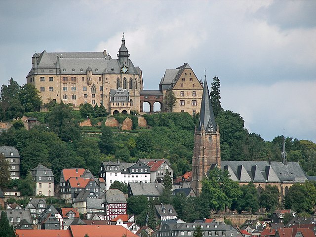

Marburg-Biedenkopf
- district in Hesse, Germany
Hiking in Marburg-Biedenkopf
Marburg-Biedenkopf, located in the state of Hesse, Germany, offers a variety of beautiful hiking trails and natural landscapes perfect for outdoor enthusiasts. The region is characterized by its picturesque countryside, dense forests, rolling hills, and charming villages. Here are some highlights of hiking in Marburg-Biedenkopf:...
- Country:
- Capital: Marburg
- Licence Plate Code: BID; MR
- Coordinates: 50° 47' 10" N, 8° 46' 19" E
- GPS tracks (wikiloc): [Link]
- AboveSeaLevel: 284 м m
- Area: 1262.56 sq km
- Population: 241279
- Web site: [Link]
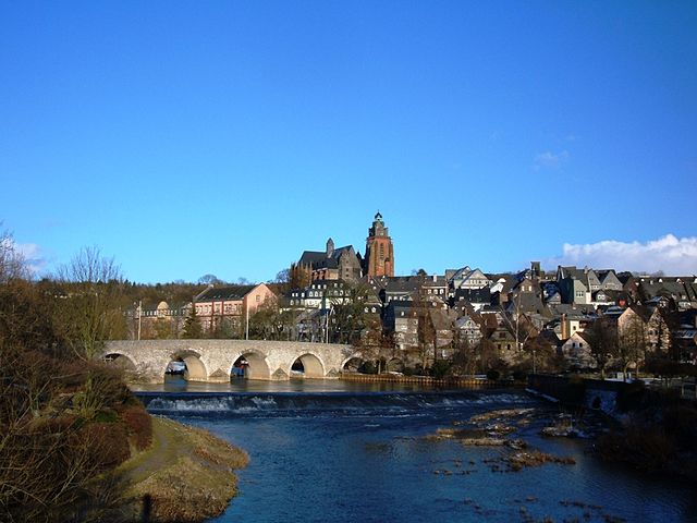

Lahn-Dill-Kreis
- district in Hesse, Germany
Hiking in Lahn-Dill-Kreis
Lahn-Dill-Kreis, located in the state of Hesse, Germany, is a picturesque region known for its beautiful landscapes, rich history, and extensive network of hiking trails. Here are some highlights about hiking in this area:...
- Country:
- Capital: Wetzlar
- Licence Plate Code: LDK
- Coordinates: 50° 33' 37" N, 8° 30' 1" E
- GPS tracks (wikiloc): [Link]
- AboveSeaLevel: 351 м m
- Area: 1066.51 sq km
- Population: 252106
- Web site: [Link]
Westerwaldkreis
- district of Rhineland-Palatinate, Germany
Hiking in Westerwaldkreis
Westerwaldkreis, located in the heart of Germany, is a charming district known for its scenic landscapes and diverse hiking trails. The region features a mix of woodlands, rolling hills, and valleys, making it an excellent destination for hikers of all levels. Here are some highlights about hiking in Westerwaldkreis:...
- Country:
- Licence Plate Code: WW
- Coordinates: 50° 31' 0" N, 7° 52' 0" E
- GPS tracks (wikiloc): [Link]
- AboveSeaLevel: 437 м m
- Web site: [Link]
Altenkirchen district
- district of Rhineland-Palatinate, Germany
Hiking in Altenkirchen district
Altenkirchen, located in the Rhineland-Palatinate region of Germany, offers a variety of hiking opportunities in a picturesque rural setting. The district is characterized by rolling hills, forests, and scenic landscapes, making it an excellent destination for both casual walkers and more experienced hikers....
- Country:
- Licence Plate Code: AK
- Coordinates: 50° 45' 0" N, 7° 45' 0" E
- GPS tracks (wikiloc): [Link]
- AboveSeaLevel: 157 м m
- Area: 642.00 sq km
- Population: 129166
- Web site: [Link]