
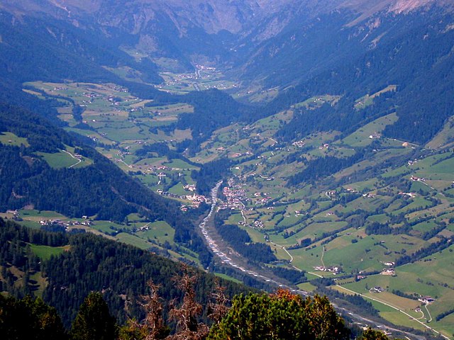
St. Leonhard in Passeier (San Leonardo in Passiria)
.svg)
- Italian comune
 Hiking in St. Leonhard in Passeier
St. Leonhard in Passeier is a picturesque village located in the South Tyrol region of northern Italy, nestled within the Ötztal Alps. It's renowned for its stunning alpine scenery, rich cultural heritage, and a variety of outdoor activities, making it an excellent destination for hikers of all skill levels. Here are some highlights of hiking in this area:
Hiking Trails
-
Falkner Hut Trail: A popular hike that offers breathtaking views of the surrounding mountains. The trail is well-marked and suitable for moderate hikers. The hut itself is a great place to rest and enjoy local cuisine.
-
Hochganghütte: This hike starts from St. Leonhard and takes you to the Hochganghütte. It's a bit more challenging and rewards you with stunning vistas of the valley and nearby peaks.
-
Passeier Valley Trail (Passeier Talweg): This longer trail runs through the entire Passeier Valley, offering various sections for day hikes. It showcases the lush green landscapes, meadows, and streams typical of the region.
-
Zoggler Reservoir: A shorter hike can take you to the Zoggler Reservoir, which is easily accessible and perfect for families. Enjoy the peaceful surroundings and the view of the water against the mountain backdrop.
Seasonal Considerations
-
Summer: During the summer months, the trails are generally clear, and the weather is favorable for hiking. Wildflowers bloom, offering vibrant landscapes. Make sure to carry enough water, as some trails are exposed to the sun.
-
Autumn: The fall foliage is breathtaking, especially in late September and early October. This is a great time for photography and enjoying the cooler temperatures.
-
Winter: While the village is great for skiing, there are also winter hiking trails. Snowshoes can be used in certain areas, providing a unique experience of the snowy landscapes.
Tips for Hiking in St. Leonhard in Passeier
- Gear Up: Wear sturdy hiking boots and dress in layers, as mountain weather can change rapidly.
- Map and Navigation: Always carry a physical map or have a GPS device, as signal may be spotty in the mountains.
- Local Customs: Respect local wildlife and adhere to trail signage to protect the natural environment.
- Hydration: Carry enough water and some snacks on longer hikes.
- Guides: Consider joining a local guided hiking tour, especially if you want to learn more about the area’s flora, fauna, and history.
Cultural Aspects
St. Leonhard in Passeier not only provides hiking opportunities but also gives you a glimpse into traditional Tyrolean culture. You might come across traditional wooden farmhouses, chapels, and even partake in local festivals, all of which enhance your hiking experience.
Whether you're seeking a leisurely hike or a challenging trek, St. Leonhard in Passeier offers a range of options amidst stunning natural beauty and deep cultural roots. Happy hiking!
- Country:

- Postal Code: 39015
- Local Dialing Code: 0473
- Licence Plate Code: BZ
- Coordinates: 46° 48' 46" N, 11° 14' 45" E


- GPS tracks (wikiloc): [Link]
- AboveSeaLevel: 689 м m
- Area: 89.03 sq km
- Population: 3551
- Web site: http://www.comune.sanleonardoinpassiria.bz.it
- Wikipedia en: wiki(en)
- Wikipedia: wiki(it)
- Wikidata storage: Wikidata: Q504149
- Wikipedia Commons Gallery: [Link]
- Wikipedia Commons Category: [Link]
- Freebase ID: [/m/0g9j9w]
- GeoNames ID: Alt: [6535925]
- VIAF ID: Alt: [152600536]
- OSM relation ID: [47310]
- GND ID: Alt: [4393552-7]
- Library of Congress authority ID: Alt: [n94105407]
- ISTAT ID: 021080
- Italian cadastre code: H952
Shares border with regions:


Sarntal
- Italian comune
Hiking in Sarntal
Sarntal, also known as the Sarntal Valley, is a beautiful hiking destination located in South Tyrol, Italy, just north of Bolzano. This area is known for its stunning landscapes, diverse flora and fauna, and rich cultural heritage. Here are some key points to consider when planning a hiking trip in Sarntal:...
- Country:
- Postal Code: 39058
- Local Dialing Code: 0471
- Licence Plate Code: BZ
- Coordinates: 46° 38' 37" N, 11° 21' 22" E
- GPS tracks (wikiloc): [Link]
- AboveSeaLevel: 2781 м m
- Area: 302.27 sq km
- Population: 7058
- Web site: [Link]


Moos in Passeier
- human settlement in Italy
Hiking in Moos in Passeier
Moos in Passeier is a picturesque village located in the Passeier Valley of South Tyrol, Italy. It's a great base for hiking enthusiasts who want to explore the stunning natural beauty of the region, which is characterized by majestic mountains, lush meadows, and charming alpine landscapes. Here are some highlights and tips for hiking in and around Moos in Passeier:...
- Country:
- Postal Code: 39013
- Local Dialing Code: 0473
- Licence Plate Code: BZ
- Coordinates: 46° 49' 54" N, 11° 10' 1" E
- GPS tracks (wikiloc): [Link]
- AboveSeaLevel: 1007 м m
- Area: 193.53 sq km
- Population: 2097
- Web site: [Link]

Ratschings
- town and commune in Italy
Hiking in Ratschings
Ratschings, located in the South Tyrol region of northern Italy, is a fantastic destination for hiking enthusiasts. The area is known for its stunning alpine scenery, diverse trails, and a variety of outdoor activities. Here are some highlights of hiking in Ratschings:...
- Country:
- Postal Code: 39040
- Local Dialing Code: 0472
- Licence Plate Code: BZ
- Coordinates: 46° 52' 0" N, 11° 18' 0" E
- GPS tracks (wikiloc): [Link]
- AboveSeaLevel: 976 м m
- Area: 203.29 sq km
- Population: 4471
- Web site: [Link]
Riffian, South Tyrol
- Italian comune
Hiking in Riffian, South Tyrol
Riffian, a picturesque village in the South Tyrol region of northern Italy, offers some fantastic opportunities for hiking enthusiasts. Nestled in the mountains, Riffian is surrounded by stunning landscapes, lush meadows, and dense forests, making it an excellent starting point for various hiking trails....
- Country:
- Postal Code: 39010
- Local Dialing Code: 0473
- Licence Plate Code: BZ
- Coordinates: 46° 42' 0" N, 11° 11' 0" E
- GPS tracks (wikiloc): [Link]
- AboveSeaLevel: 504 м m
- Area: 35.94 sq km
- Population: 1357
- Web site: [Link]


St. Martin in Passeier
- Italian comune
Hiking in St. Martin in Passeier
Hiking in St. Martin in Passeier, located in South Tyrol, Italy, offers a stunning opportunity to explore the natural beauty of the Passeier Valley. The region is known for its picturesque landscapes, charming villages, and a variety of hiking trails suitable for different skill levels....
- Country:
- Postal Code: 39010
- Local Dialing Code: 0473
- Licence Plate Code: BZ
- Coordinates: 46° 47' 2" N, 11° 13' 38" E
- GPS tracks (wikiloc): [Link]
- AboveSeaLevel: 600 м m
- Area: 29.99 sq km
- Population: 3233
- Web site: [Link]


Schenna
- Italian comune
Hiking in Schenna
Schenna, located near Merano in South Tyrol, Italy, is a great destination for hiking enthusiasts. The region is known for its breathtaking alpine scenery, charming villages, and well-maintained hiking trails suitable for all levels, from beginners to experienced hikers....
- Country:
- Postal Code: 39017
- Local Dialing Code: 0473
- Licence Plate Code: BZ
- Coordinates: 46° 41' 24" N, 11° 11' 11" E
- GPS tracks (wikiloc): [Link]
- AboveSeaLevel: 600 м m
- Area: 48.13 sq km
- Population: 2918
- Web site: [Link]