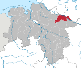
Heidekreis (Landkreis Heidekreis)

- district in Lower Saxony, Germany
 Hiking in Heidekreis
Heidekreis, located in Lower Saxony, Germany, offers a variety of hiking opportunities amidst beautiful natural landscapes. The region is characterized by its mix of heathlands, forests, and moorlands, making it an attractive destination for outdoor enthusiasts.
Key Hiking Areas:
-
Lüneburg Heath (Lüneburger Heide):
- One of the most famous regions in Heidekreis, Lüneburg Heath is known for its stunning heath landscapes, particularly in late summer when the heather blooms in vibrant purple.
- There are numerous well-marked trails that cater to different skill levels, ranging from short walks to more challenging hikes. Popular trails include the "Heidschnuckenweg," a long-distance hiking path that runs through the heart of the heath.
-
Nature Reserves:
- Various nature reserves in the area provide opportunities for hiking while enjoying diverse ecosystems. Look for trails that weave through protected areas, where you can spot native wildlife and unique plant species.
-
Forests and Moorlands:
- The region is dotted with dense forests, such as the "Bockelkamp Forest," that offer shaded paths and scenic views. The moorlands provide a unique hiking experience where you can explore rare habitats.
Tips for Hiking in Heidekreis:
- Trail Maps: Make sure to carry a trail map or download a hiking app for offline access, as signage can vary.
- Weather Preparedness: Check the weather forecast before heading out. The conditions can change quickly, especially in forested areas.
- Footwear: Wear sturdy hiking boots that provide good ankle support, especially if you plan on tackling uneven terrain or muddy paths.
- Hydration and Snacks: Bring plenty of water and snacks, particularly if you plan on hiking longer distances.
- Respect Nature: Stick to marked trails to protect the delicate ecosystems in the area. Make sure to follow local regulations and guidelines.
Local Amenities:
- After your hike, consider visiting local villages for accommodations, restaurants, and shops that offer regional specialties. The hospitality in the Heidekreis region is warm and welcoming, perfect for winding down after a day of outdoor adventure.
Whether a novice or experienced hiker, Heidekreis provides a delightful mix of natural beauty and tranquility for a memorable hiking experience.
- Country:

- Capital: Bad Fallingbostel
- Licence Plate Code: HK
- Coordinates: 52° 55' 12" N, 9° 45' 0" E


- GPS tracks (wikiloc): [Link]
- AboveSeaLevel: 64 м m
- Area: 1873.50 sq km
- Population: 139641
- Web site: http://www.heidekreis.de
- Wikipedia en: wiki(en)
- Wikipedia: wiki(de)
- Wikidata storage: Wikidata: Q5922
- Wikipedia Commons Gallery: [Link]
- Wikipedia Commons Category: [Link]
- Wikipedia Commons Maps Category: [Link]
- Freebase ID: [/m/0138vy]
- GeoNames ID: Alt: [2831482]
- VIAF ID: Alt: [246524890]
- OSM relation ID: [62674]
- GND ID: Alt: [4055467-3]
- archINFORM location ID: [11065]
- TGN ID: [7099586]
- Historical Gazetteer (GOV) ID: [adm_133358]
- NUTS code: [DE938]
- German district key: 03358
Includes regions:

Rethem/Aller
- Samtgemeinde in Lower Saxony
Hiking in Rethem/Aller
Rethem (Aller) is a small town in Lower Saxony, Germany, located in the Samtgemeinde of Rethem. The region is characterized by its beautiful landscapes, including forests, fields, and rivers, making it a pleasant destination for hiking enthusiasts....
- Country:
- Coordinates: 52° 46' 48" N, 9° 22' 48" E
- GPS tracks (wikiloc): [Link]
- Population: 4554
- Web site: [Link]

Schwarmstedt
- Samtgemeinde in Lower Saxony
Hiking in Schwarmstedt
Schwarmstedt, located in Lower Saxony, Germany, is part of the Samtgemeinde of Schwarmstedt. It may not be as renowned as some other hiking destinations in Germany, but it offers a variety of enjoyable outdoor experiences, particularly for those who appreciate peaceful country landscapes and scenic nature trails....
- Country:
- Coordinates: 52° 40' 0" N, 9° 37' 0" E
- GPS tracks (wikiloc): [Link]
- Population: 12737
- Web site: [Link]

Ahlden
- Samtgemeinde in Lower Saxony
Hiking in Ahlden
Ahlden, located in the Samtgemeinde area of Lower Saxony, Germany, offers a charming setting for hiking enthusiasts. The region is characterized by its picturesque countryside, which includes rolling hills, forests, and meandering rivers, making it conducive for both casual strolls and more vigorous hikes....
- Country:
- Coordinates: 52° 45' 49" N, 9° 35' 21" E
- GPS tracks (wikiloc): [Link]
- Area: 84.79 sq km
- Population: 6650
- Web site: [Link]


Bad Fallingbostel
- municipality of Germany
Hiking in Bad Fallingbostel
Bad Fallingbostel, located in Lower Saxony, Germany, offers a variety of hiking opportunities that showcase the region's natural beauty and diverse landscapes. Here’s an overview of what you can expect when hiking in and around Bad Fallingbostel:...
- Country:
- Postal Code: 29683
- Local Dialing Code: 05163; 05162
- Licence Plate Code: HK
- Coordinates: 52° 52' 3" N, 9° 41' 48" E
- GPS tracks (wikiloc): [Link]
- AboveSeaLevel: 67 м m
- Area: 63.7 sq km
- Population: 11413
- Web site: [Link]

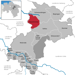
Neuenkirchen
- place in Lower Saxony, Germany
Hiking in Neuenkirchen
Neuenkirchen, located in the beautiful Lüneburg Heath (Lüneburger Heide) of northern Germany, offers a serene hiking experience amidst stunning natural landscapes. The area is characterized by its unique heathlands, dense forests, and charming villages, making it a great destination for outdoor enthusiasts....
- Country:
- Postal Code: 29643
- Local Dialing Code: 05195
- Licence Plate Code: HK
- Coordinates: 53° 2' 5" N, 9° 42' 29" E
- GPS tracks (wikiloc): [Link]
- AboveSeaLevel: 69 м m
- Area: 96.68 sq km
- Population: 5578
- Web site: [Link]


Schneverdingen
- municipality of Germany
Hiking in Schneverdingen
Schneverdingen, located in Lower Saxony, Germany, is a charming area known for its beautiful landscapes and diverse hiking opportunities. Nestled in the Lüneburg Heath, Schneverdingen offers a mix of heathland, forest, and picturesque villages that make it a perfect destination for hikers of all levels....
- Country:
- Postal Code: 29640
- Local Dialing Code: 05193
- Licence Plate Code: SFA
- Coordinates: 53° 7' 0" N, 9° 48' 0" E
- GPS tracks (wikiloc): [Link]
- AboveSeaLevel: 97 м m
- Area: 234.58 sq km
- Population: 18624
- Web site: [Link]


Bispingen
- municipality of Germany
Hiking in Bispingen
Bispingen is a charming small town located in Lower Saxony, Germany, and is part of the German Lüneburg Heath region. This area is known for its beautiful landscapes, extensive hiking trails, and unique heathland scenery, making it a great destination for outdoor enthusiasts....
- Country:
- Postal Code: 29646
- Local Dialing Code: 05194
- Licence Plate Code: SFA
- Coordinates: 53° 4' 58" N, 9° 59' 54" E
- GPS tracks (wikiloc): [Link]
- AboveSeaLevel: 78 м m
- Area: 128.55 sq km
- Population: 6486
- Web site: [Link]


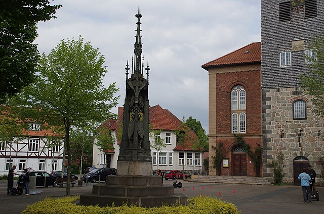
Soltau
- town in Heidekreis District, in Lower Saxony, Germany
Hiking in Soltau
Hiking in Soltau, a quaint town located in Lower Saxony, Germany, offers a blend of scenic landscapes, lush forests, and a range of trails suitable for all skill levels. The region is part of the Lüneburg Heath (Lüneburger Heide), known for its picturesque heathland, rolling hills, and charming villages....
- Country:
- Postal Code: 29614
- Local Dialing Code: 05191
- Licence Plate Code: HK
- Coordinates: 52° 59' 0" N, 9° 50' 0" E
- GPS tracks (wikiloc): [Link]
- AboveSeaLevel: 57 м m
- Area: 203.25 sq km
- Population: 21324
- Web site: [Link]


Munster, Lower Saxony
- municipality of Germany
Hiking in Munster, Lower Saxony
Munster, Lower Saxony, is surrounded by beautiful landscapes that offer a variety of hiking opportunities for enthusiasts of all levels. The region features a mix of scenic countryside, forested areas, and picturesque villages, making it an ideal destination for hiking....
- Country:
- Postal Code: 29633
- Local Dialing Code: 05192
- Licence Plate Code: HK
- Coordinates: 52° 59' 19" N, 10° 5' 28" E
- GPS tracks (wikiloc): [Link]
- AboveSeaLevel: 73 м m
- Area: 193.42 sq km
- Population: 14958
- Web site: [Link]

Walsrode
- municipality of Germany
Hiking in Walsrode
Walsrode, located in Lower Saxony, Germany, is a beautiful destination for hiking enthusiasts, offering a mix of scenic landscapes, diverse wildlife, and historical sites. Here are some highlights of hiking in the Walsrode area:...
- Country:
- Postal Code: 29664
- Local Dialing Code: 05168; 05167; 05166; 05162; 05161; 04238
- Licence Plate Code: HK
- Coordinates: 52° 52' 0" N, 9° 35' 0" E
- GPS tracks (wikiloc): [Link]
- AboveSeaLevel: 49 м m
- Area: 270.68 sq km
- Population: 23139
- Web site: [Link]

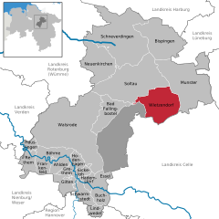
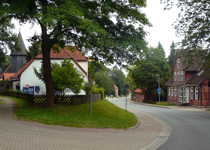
Wietzendorf
- municipality of Germany
Hiking in Wietzendorf
Wietzendorf, located in Lower Saxony, Germany, offers a variety of hiking trails that showcase the beautiful nature and landscapes of the region. Here are some highlights to consider when hiking in Wietzendorf:...
- Country:
- Postal Code: 29649
- Local Dialing Code: 05196
- Licence Plate Code: SFA
- Coordinates: 52° 55' 0" N, 9° 59' 0" E
- GPS tracks (wikiloc): [Link]
- AboveSeaLevel: 66 м m
- Area: 106.88 sq km
- Population: 4133
- Web site: [Link]

Osterheide
- unincorporated area in Germany
Hiking in Osterheide
Osterheide is a beautiful area located in northern Germany, known for its scenic natural beauty, forests, and heaths. It offers a perfect setting for hiking enthusiasts of all levels. Here are some key points about hiking in Osterheide:...
- Country:
- Postal Code: 29649; 29683; 29664
- Local Dialing Code: 05196; 05162; 05167; 05163
- Licence Plate Code: HK
- Coordinates: 52° 51' 0" N, 9° 44' 0" E
- GPS tracks (wikiloc): [Link]
- AboveSeaLevel: 62 м m
- Area: 177.99 sq km
- Population: 1961
- Web site: [Link]


Bomlitz
- municipality of Germany
Hiking in Bomlitz
Bomlitz is a small town located in Lower Saxony, Germany, known for its picturesque scenery and access to natural landscapes. While it may not be as well-known as larger hiking destinations, there are still plenty of opportunities for outdoor enthusiasts to explore the surrounding areas....
- Country:
- Postal Code: 29699
- Local Dialing Code: 05197; 05163; 05161; 04262
- Licence Plate Code: SFA
- Coordinates: 52° 53' 0" N, 9° 39' 0" E
- GPS tracks (wikiloc): [Link]
- AboveSeaLevel: 52 м m
- Area: 64 sq km
- Population: 6955
- Web site: [Link]
Shares border with regions:


Harburg
- German district in Lower Saxony
Hiking in Harburg
Harburg, a district in the southern part of Hamburg, Germany, offers various hiking opportunities that allow you to explore the beautiful natural landscapes and scenic views of the region. Here are some key points about hiking in Harburg:...
- Country:
- Capital: Winsen
- Licence Plate Code: WL
- Coordinates: 53° 19' 43" N, 9° 58' 11" E
- GPS tracks (wikiloc): [Link]
- AboveSeaLevel: 49 м m
- Population: 250326
- Web site: [Link]

Lüneburg
- German district of Lower Saxony
Hiking in Lüneburg
Lüneburg district, located in Lower Saxony, Germany, is a wonderful area for hiking enthusiasts. The region is known for its scenic landscapes, featuring rolling hills, forests, rivers, and charming villages. Here are some highlights for hiking in Lüneburg:...
- Country:
- Capital: Lüneburg
- Licence Plate Code: LG
- Coordinates: 53° 15' 0" N, 10° 30' 0" E
- GPS tracks (wikiloc): [Link]
- AboveSeaLevel: 8 м m
- Area: 1323.10 sq km
- Population: 181605
- Web site: [Link]
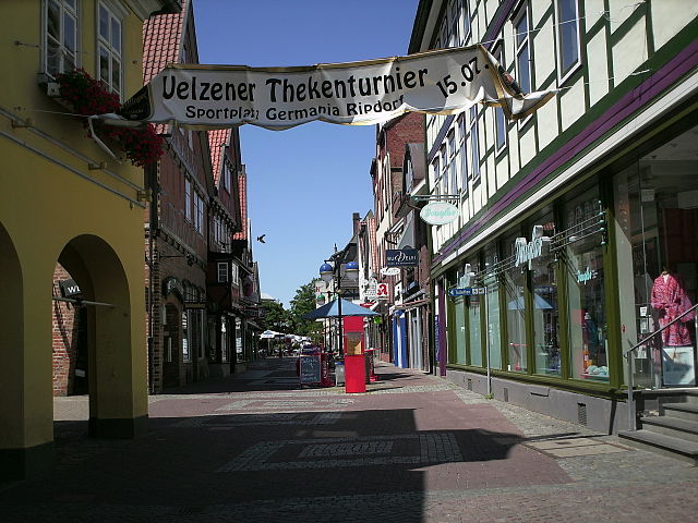

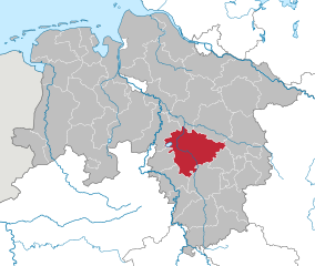
Uelzen District
- German district in Lower Saxony
Hiking in Uelzen District
Uelzen District in Lower Saxony, Germany, offers a variety of hiking opportunities for outdoor enthusiasts. While it might not be as widely known for hiking as some other regions, it provides beautiful natural scenery, charming villages, and historical sites to explore. Here are some aspects to consider for hiking in Uelzen:...
- Country:
- Licence Plate Code: UE
- Coordinates: 53° 0' 0" N, 10° 34' 48" E
- GPS tracks (wikiloc): [Link]
- AboveSeaLevel: 32 м m
- Area: 1454.00 sq km
- Population: 92961
- Web site: [Link]
Celle
- German district of Lower Saxony
Hiking in Celle
Celle district, located in Lower Saxony, Germany, offers a variety of hiking opportunities surrounded by beautiful landscapes, historic towns, and natural parks. Here are some highlights for hiking enthusiasts in the area:...
- Country:
- Licence Plate Code: CE
- Coordinates: 52° 34' 48" N, 10° 4' 48" E
- GPS tracks (wikiloc): [Link]
- AboveSeaLevel: 59 м m
- Area: 1554.00 sq km
- Population: 178370
- Web site: [Link]


Rotenburg (Wümme)
- German district in Lower Saxony
Hiking in Rotenburg (Wümme)
Rotenburg (district), located in Lower Saxony, Germany, offers various hiking opportunities, particularly for those interested in exploring scenic landscapes and natural beauty. Here are some highlights and suggestions for hiking in this region:...
- Country:
- Licence Plate Code: ROW; BRV
- Coordinates: 53° 15' 0" N, 9° 19' 48" E
- GPS tracks (wikiloc): [Link]
- AboveSeaLevel: 28 м m
- Population: 163372
- Web site: [Link]


Verden
- district in Lower Saxony, Germany
Hiking in Verden
Verden, located in Lower Saxony, Germany, is an area that offers various outdoor activities, including hiking. The district is characterized by its lush landscapes, woodlands, and scenic countryside, making it a pleasant spot for nature lovers and hikers alike....
- Country:
- Licence Plate Code: VER
- Coordinates: 53° 0' 0" N, 9° 10' 12" E
- GPS tracks (wikiloc): [Link]
- AboveSeaLevel: 23 м m
- Area: 787.70 sq km
- Population: 135842
- Web site: [Link]


Nienburg/Weser
- district in Lower Saxony, Germany
Hiking in Nienburg/Weser
Nienburg (district) in Lower Saxony, Germany, offers a range of outdoor activities, including hiking, which can be enjoyed in its scenic landscapes. While the region isn't known for high mountains, it features beautiful rolling hills, tranquil rivers, and charming villages, making it an excellent area for hiking enthusiasts who appreciate more gentle terrains and lush nature....
- Country:
- Licence Plate Code: NI
- Coordinates: 52° 40' 12" N, 9° 10' 12" E
- GPS tracks (wikiloc): [Link]
- AboveSeaLevel: 21 м m
- Area: 1399.00 sq km
- Population: 121503
- Web site: [Link]

Hanover region
- district in Lower Saxony, Germany
Hiking in Hanover region
The Hanover Region, located in Lower Saxony, Germany, offers a variety of hiking opportunities for both beginners and experienced hikers alike. With its mix of natural landscapes, historical sites, and well-maintained trails, the region is a great destination for outdoor enthusiasts....
- Country:
- Capital: Hanover
- Licence Plate Code: H
- Coordinates: 52° 25' 12" N, 9° 43' 12" E
- GPS tracks (wikiloc): [Link]
- AboveSeaLevel: 55 м m
- Area: 2291 sq km
- Population: 1149594
- Web site: [Link]