Waldaschaffer Forst (Waldaschaffer Forst)

- unincorporated area in Germany
 Hiking in Waldaschaffer Forst
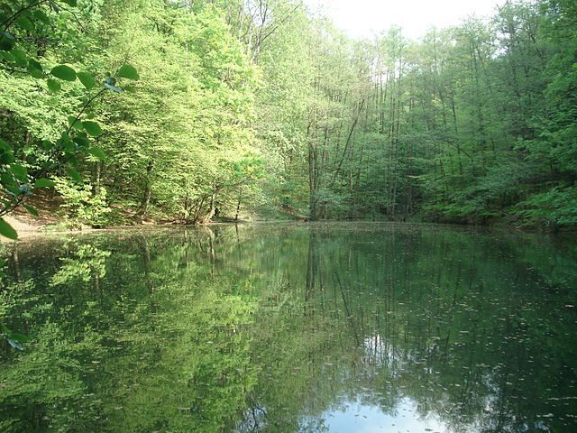
Waldaschaffer Forst, located near the town of Waldaschaff in Bavaria, Germany, offers a variety of hiking opportunities for outdoor enthusiasts. This forested area is characterized by its stunning natural beauty, diverse ecosystems, and well-maintained trails, making it an excellent destination for hikers of all skill levels.
Key Features of Hiking in Waldaschaffer Forst:
-
Scenic Trails: The area has several marked hiking paths that wind through picturesque woodlands, meadows, and hills. These trails vary in difficulty, so there's something for everyone, from casual walkers to experienced hikers.
-
Flora and Fauna: Hikers can expect to see a rich variety of plant life and wildlife. The forest is home to many species of trees, shrubs, and flowers, as well as birds and small mammals, which can enhance the outdoor experience.
-
Panoramic Views: Certain trails offer breathtaking views of the surrounding landscape, particularly at higher elevations. Make sure to take breaks at lookout points to enjoy the scenery.
-
Accessibility: The forest is relatively accessible, with trails that are well-marked and can be navigated by foot. Many paths are suitable for families, providing a great opportunity for a day out with children.
-
Nearby Attractions: Exploring Waldaschaffer Forst can be part of a larger adventure in the region. The surrounding area offers picturesque villages, historical sites, and other outdoor activities like cycling.
-
Seasonal Activities: Hiking in Waldaschaffer Forst can be enjoyed year-round. In the autumn, the foliage is particularly stunning, while winter months may provide opportunities for snowshoeing or winter hiking, depending on the weather.
Tips for Hiking in Waldaschaffer Forst:
- Check Trail Conditions: Before heading out, it's a good idea to check trail conditions or park updates, especially after heavy rainfall or adverse weather.
- Wear Proper Footwear: Good hiking boots or shoes are essential for comfort and safety, especially on uneven terrain.
- Stay Hydrated: Bring enough water, especially on longer hikes, and consider packing snacks for energy.
- Dress Appropriately: Be prepared for changing weather conditions by dressing in layers.
- Respect Nature: Follow the Leave No Trace principles to preserve the area's natural beauty for future visitors.
If you're planning a hiking trip to Waldaschaffer Forst, make sure to take the time to enjoy the tranquility of nature and the beauty of the Bavarian countryside!
- Country:

- Coordinates: 49° 57' 22" N, 9° 19' 37" E


- GPS tracks (wikiloc): [Link]
- Wikidata storage: Wikidata: Q964694
- Wikipedia Commons Category: [Link]
- OSM relation ID: [534756]
- Bavarikon ID: [ODB_A00002275]
Shares border with regions:

Bessenbach
- municipality of Germany
Hiking in Bessenbach
Bessenbach, located in Bavaria, Germany, is a charming area with beautiful natural surroundings perfect for hiking enthusiasts. Here are some highlights of hiking in and around Bessenbach:...
- Country:
- Postal Code: 63856
- Local Dialing Code: 06095
- Licence Plate Code: AB
- Coordinates: 49° 58' 0" N, 9° 16' 0" E
- GPS tracks (wikiloc): [Link]
- AboveSeaLevel: 195 м m
- Area: 29.99 sq km
- Population: 4831
- Web site: [Link]


Mespelbrunn
- municipality of Germany
Hiking in Mespelbrunn
Mespelbrunn is a picturesque village located in Bavaria, Germany, and is particularly well-known for its charming castle, Schloss Mespelbrunn, set amidst the lush forests of the Spessart mountain region. Hiking around Mespelbrunn offers a delightful combination of natural beauty, historical sites, and peaceful trails....
- Country:
- Postal Code: 63875
- Local Dialing Code: 06092
- Licence Plate Code: AB
- Coordinates: 49° 55' 0" N, 9° 17' 0" E
- GPS tracks (wikiloc): [Link]
- AboveSeaLevel: 269 м m
- Area: 15.53 sq km
- Population: 2073
- Web site: [Link]

Weibersbrunn
- municipality of Germany
Hiking in Weibersbrunn
Weibersbrunn is a charming village located in the Bavarian region of Germany, surrounded by beautiful landscapes that are perfect for hiking enthusiasts. Here’s a general overview of hiking in Weibersbrunn:...
- Country:
- Postal Code: 63879
- Local Dialing Code: 06094
- Licence Plate Code: AB
- Coordinates: 49° 56' 0" N, 9° 22' 0" E
- GPS tracks (wikiloc): [Link]
- AboveSeaLevel: 358 м m
- Area: 2.89 sq km
- Population: 1934
- Web site: [Link]


Waldaschaff
- municipality of Germany
Hiking in Waldaschaff
Waldaschaff is a charming village located in the Ashke Valley in Bavaria, Germany, known for its picturesque landscapes and scenic hiking trails. Hiking in this area offers a wonderful opportunity to explore nature and enjoy the breathtaking views of the lush forests, rolling hills, and the nearby Spessart Nature Park....
- Country:
- Postal Code: 63857
- Local Dialing Code: 06095
- Licence Plate Code: AB
- Coordinates: 49° 58' 0" N, 9° 18' 0" E
- GPS tracks (wikiloc): [Link]
- AboveSeaLevel: 192 м m
- Area: 6.59 sq km
- Population: 3692
- Web site: [Link]


Rothenbucher Forst
- unincorporated area in Germany
Hiking in Rothenbucher Forst
Rothenbucher Forst is a beautiful forest area located in Bavaria, Germany, known for its lush landscapes and diverse ecosystems. It offers a variety of hiking trails suitable for different skill levels, making it a great destination for both beginners and experienced hikers. Here are some highlights and tips for hiking in Rothenbucher Forst:...
- Country:
- Coordinates: 49° 58' 42" N, 9° 25' 7" E
- GPS tracks (wikiloc): [Link]
Forst Hain im Spessart
- unincorporated area in Germany
Hiking in Forst Hain im Spessart
Forst Hain im Spessart is a wonderful location for hiking, situated in the Spessart forest region in Bavaria, Germany. Known for its picturesque landscapes, dense woodlands, rolling hills, and diverse flora and fauna, this area provides an excellent setting for outdoor enthusiasts of all skill levels....
- Country:
- Coordinates: 50° 0' 7" N, 9° 21' 31" E
- GPS tracks (wikiloc): [Link]


Rohrbrunner Forst
- unincorporated area in Germany
Hiking in Rohrbrunner Forst
Rohrbrunner Forst, located in Germany, is a beautiful area for hiking that offers a mix of natural landscapes, tranquility, and a variety of trails suitable for different skill levels. Here are some key points to consider when hiking in Rohrbrunner Forst:...
- Country:
- Coordinates: 49° 54' 23" N, 9° 23' 12" E
- GPS tracks (wikiloc): [Link]