Forst Hain im Spessart (Forst Hain im Spessart)

- unincorporated area in Germany
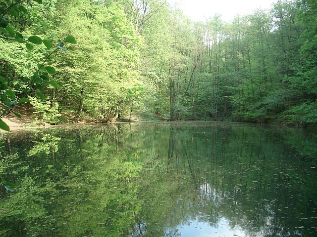
 Hiking in Forst Hain im Spessart
Forst Hain im Spessart is a wonderful location for hiking, situated in the Spessart forest region in Bavaria, Germany. Known for its picturesque landscapes, dense woodlands, rolling hills, and diverse flora and fauna, this area provides an excellent setting for outdoor enthusiasts of all skill levels.
Key Features of Hiking in Forst Hain im Spessart:
-
Trails: There are various marked hiking trails that cater to different levels of experience. From leisurely strolls to more challenging hikes, you can find routes that suit your preference. Make sure to check local maps or guides for trail descriptions and difficulty ratings.
-
Scenery: The region is renowned for its natural beauty including lush beech and oak forests, charming meadows, and scenic vistas. As you hike, you'll have opportunities for breathtaking views, especially from higher elevations.
-
Wildlife: The Spessart is home to a wide variety of wildlife. Keep an eye out for deer, various bird species, and other small animals along the trails. The tranquility of the forest provides a great opportunity for wildlife watching.
-
History and Culture: The Spessart region has a rich history. You might discover historical landmarks, old mining sites, or remnants of past settlements along the trails. Some of the routes may also lead you to picturesque villages and traditional Bavarian architecture.
-
Accessibility: Forst Hain is accessible by car and public transport, and it's a good base from which to explore the larger Spessart area. Ensure you have a map or a GPS device with you for navigation.
-
Safety and Preparation: Always prepare properly for your hike. Wear appropriate footwear, bring water, snacks, and a first-aid kit. Familiarize yourself with the weather conditions and ensure you have a means of communication in case of emergencies.
-
Local Regulations: Check local guidelines regarding hiking, such as designated trails, camping restrictions, and any conservation efforts. It's essential to practice Leave No Trace principles to preserve the natural beauty of the area.
Whether you’re seeking a peaceful retreat in nature or a more strenuous adventure, Forst Hain im Spessart offers a memorable hiking experience. Enjoy the journey, and don’t forget to take your camera to capture the stunning landscapes!
- Country:

- Coordinates: 50° 0' 7" N, 9° 21' 31" E


- GPS tracks (wikiloc): [Link]
- Wikidata storage: Wikidata: Q964633
- Wikipedia Commons Category: [Link]
- OSM relation ID: [2610204]
Shares border with regions:

Bessenbach
- municipality of Germany
Hiking in Bessenbach
Bessenbach, located in Bavaria, Germany, is a charming area with beautiful natural surroundings perfect for hiking enthusiasts. Here are some highlights of hiking in and around Bessenbach:...
- Country:
- Postal Code: 63856
- Local Dialing Code: 06095
- Licence Plate Code: AB
- Coordinates: 49° 58' 0" N, 9° 16' 0" E
- GPS tracks (wikiloc): [Link]
- AboveSeaLevel: 195 м m
- Area: 29.99 sq km
- Population: 4831
- Web site: [Link]


Heigenbrücken
- municipality of Germany
Hiking in Heigenbrücken
Heigenbrücken is a small town located in the Spessart region of Bavaria, Germany. It’s known for its beautiful landscapes, making it a great destination for hiking enthusiasts. Here are some details about hiking in the area:...
- Country:
- Postal Code: 63869
- Local Dialing Code: 06020
- Licence Plate Code: AB
- Coordinates: 50° 2' 0" N, 9° 23' 0" E
- GPS tracks (wikiloc): [Link]
- AboveSeaLevel: 273 м m
- Area: 6.70 sq km
- Population: 2332
- Web site: [Link]

Neuhütten
- municipality of Germany
Hiking in Neuhütten
Neuhütten, located in Germany, offers a variety of hiking opportunities for outdoor enthusiasts. Nestled in the picturesque Spessart forest region, it features dense woods, rolling hills, and beautiful landscapes. Here are some highlights and tips for hiking in Neuhütten:...
- Country:
- Postal Code: 97843
- Local Dialing Code: 06020
- Licence Plate Code: MSP
- Coordinates: 50° 0' 0" N, 9° 25' 0" E
- GPS tracks (wikiloc): [Link]
- AboveSeaLevel: 270 м m
- Area: 5.95 sq km
- Population: 1092
- Web site: [Link]


Laufach
- municipality of Germany
Hiking in Laufach
Laufach, located in Bavaria, Germany, is a charming town that offers a wonderful opportunity for hiking enthusiasts. Surrounded by beautiful landscapes, lush forests, and scenic views, there are several trails and paths suitable for various skill levels....
- Country:
- Postal Code: 63846
- Local Dialing Code: 06093
- Licence Plate Code: AB
- Coordinates: 50° 1' 0" N, 9° 18' 0" E
- GPS tracks (wikiloc): [Link]
- AboveSeaLevel: 180 м m
- Area: 15.60 sq km
- Population: 5176
- Web site: [Link]


Rothenbucher Forst
- unincorporated area in Germany
Hiking in Rothenbucher Forst
Rothenbucher Forst is a beautiful forest area located in Bavaria, Germany, known for its lush landscapes and diverse ecosystems. It offers a variety of hiking trails suitable for different skill levels, making it a great destination for both beginners and experienced hikers. Here are some highlights and tips for hiking in Rothenbucher Forst:...
- Country:
- Coordinates: 49° 58' 42" N, 9° 25' 7" E
- GPS tracks (wikiloc): [Link]


Sailaufer Forst
- unincorporated area in Germany
Hiking in Sailaufer Forst
Sailaufer Forst is a beautiful forest area that provides a wonderful environment for hiking and nature exploration. If you're planning to hike there, here are some key points to consider:...
- Country:
- Coordinates: 50° 2' 30" N, 9° 17' 58" E
- GPS tracks (wikiloc): [Link]


Waldaschaffer Forst
- unincorporated area in Germany
Hiking in Waldaschaffer Forst
Waldaschaffer Forst, located near the town of Waldaschaff in Bavaria, Germany, offers a variety of hiking opportunities for outdoor enthusiasts. This forested area is characterized by its stunning natural beauty, diverse ecosystems, and well-maintained trails, making it an excellent destination for hikers of all skill levels....
- Country:
- Coordinates: 49° 57' 22" N, 9° 19' 37" E
- GPS tracks (wikiloc): [Link]