Évette-Salbert (Évette-Salbert)

- commune in Territoire de Belfort, France
- Country:

- Postal Code: 90350
- Coordinates: 47° 40' 30" N, 6° 47' 54" E


- GPS tracks (wikiloc): [Link]
- AboveSeaLevel: 391 м m
- Area: 9.16 sq km
- Population: 2073
- Web site: http://www.evettesalbert.fr
- Wikipedia en: wiki(en)
- Wikipedia: wiki(fr)
- Wikidata storage: Wikidata: Q291404
- Wikipedia Commons Category: [Link]
- Freebase ID: [/m/03mh9jc]
- GeoNames ID: Alt: [3019284]
- SIREN number: [219000429]
- BnF ID: [15279983t]
- INSEE municipality code: 90042
Shares border with regions:
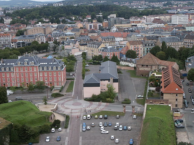

Belfort
- commune in Territoire de Belfort, France
 Hiking in Belfort
Belfort, a city in northeastern France, is known for its scenic landscapes and historical significance, particularly the impressive citadel built by Vauban. When it comes to hiking, the area surrounding Belfort offers a variety of trails that cater to different skill levels and preferences, showcasing the natural beauty of the region....
- Country:
- Postal Code: 90000
- Coordinates: 47° 38' 15" N, 6° 51' 46" E
- GPS tracks (wikiloc): [Link]
- AboveSeaLevel: 358 м m
- Area: 17.1 sq km
- Population: 49519
- Web site: [Link]

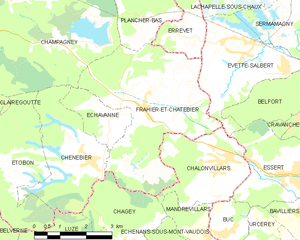
Frahier-et-Chatebier
- commune in Haute-Saône, France
- Country:
- Postal Code: 70400
- Coordinates: 47° 39' 37" N, 6° 44' 51" E
- GPS tracks (wikiloc): [Link]
- Area: 17.39 sq km
- Population: 1360
- Web site: [Link]


Sermamagny
- commune in Territoire de Belfort, France
- Country:
- Postal Code: 90300
- Coordinates: 47° 41' 32" N, 6° 50' 9" E
- GPS tracks (wikiloc): [Link]
- Area: 7.9 sq km
- Population: 817
- Web site: [Link]

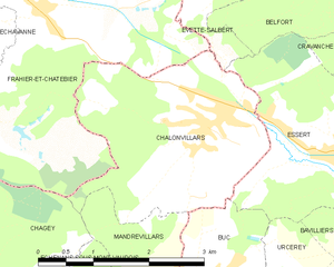
Châlonvillars
- commune in Haute-Saône, France
- Country:
- Postal Code: 70400
- Coordinates: 47° 38' 22" N, 6° 47' 11" E
- GPS tracks (wikiloc): [Link]
- Area: 7.6 sq km
- Population: 1256
- Web site: [Link]


Errevet
- commune in Haute-Saône, France
- Country:
- Postal Code: 70400
- Coordinates: 47° 41' 6" N, 6° 46' 33" E
- GPS tracks (wikiloc): [Link]
- Area: 3.28 sq km
- Population: 251
- Web site: [Link]


Lachapelle-sous-Chaux
- commune in Territoire de Belfort, France
- Country:
- Postal Code: 90300
- Coordinates: 47° 42' 17" N, 6° 49' 16" E
- GPS tracks (wikiloc): [Link]
- Area: 11.16 sq km
- Population: 718
- Web site: [Link]


Essert
- commune in Territoire de Belfort, France
Hiking in Essert
Hiking in Essert, located in the Territoire de Belfort region of France, offers a delightful combination of natural beauty, picturesque landscapes, and accessibility for outdoor enthusiasts. Here are some highlights and tips for hiking in this area:...
- Country:
- Postal Code: 90850
- Coordinates: 47° 37' 55" N, 6° 48' 59" E
- GPS tracks (wikiloc): [Link]
- Area: 7.01 sq km
- Population: 3268
- Web site: [Link]

Valdoie
- commune in Territoire de Belfort, France
- Country:
- Postal Code: 90300
- Coordinates: 47° 40' 2" N, 6° 50' 31" E
- GPS tracks (wikiloc): [Link]
- Area: 4.66 sq km
- Population: 5382
- Web site: [Link]