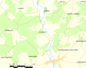
Lapan (Lapan)

- commune in Cher, France
- Country:

- Postal Code: 18340
- Coordinates: 46° 55' 24" N, 2° 17' 59" E


- GPS tracks (wikiloc): [Link]
- Area: 10.5 sq km
- Population: 200
- Wikipedia en: wiki(en)
- Wikipedia: wiki(fr)
- Wikidata storage: Wikidata: Q530004
- Wikipedia Commons Category: [Link]
- Freebase ID: [/m/03mfd21]
- GeoNames ID: Alt: [6428201]
- SIREN number: [211801220]
- BnF ID: [15249468x]
- INSEE municipality code: 18122
Shares border with regions:


Lunery
- commune in Cher, France
- Country:
- Postal Code: 18400
- Coordinates: 46° 56' 7" N, 2° 16' 16" E
- GPS tracks (wikiloc): [Link]
- Area: 32.87 sq km
- Population: 1512

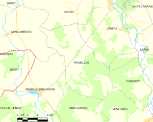
Primelles
- commune in Cher, France
- Country:
- Postal Code: 18400
- Coordinates: 46° 55' 42" N, 2° 12' 47" E
- GPS tracks (wikiloc): [Link]
- Area: 26.57 sq km
- Population: 250
Sainte-Lunaise
- commune in Cher, France
- Country:
- Postal Code: 18340
- Coordinates: 46° 55' 14" N, 2° 20' 54" E
- GPS tracks (wikiloc): [Link]
- Area: 13.95 sq km
- Population: 18
Saint-Caprais
- commune in Cher, France
- Country:
- Postal Code: 18400
- Coordinates: 46° 58' 6" N, 2° 17' 36" E
- GPS tracks (wikiloc): [Link]
- Area: 14.42 sq km
- Population: 772

Corquoy
- commune in Cher, France
- Country:
- Postal Code: 18190
- Coordinates: 46° 53' 50" N, 2° 17' 31" E
- GPS tracks (wikiloc): [Link]
- Area: 22.62 sq km
- Population: 205

Arçay
- commune in Cher, France
- Country:
- Postal Code: 18340
- Coordinates: 46° 56' 54" N, 2° 20' 25" E
- GPS tracks (wikiloc): [Link]
- Area: 18.32 sq km
- Population: 516