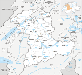
Obwalden (Kanton Obwalden)


- canton of Switzerland
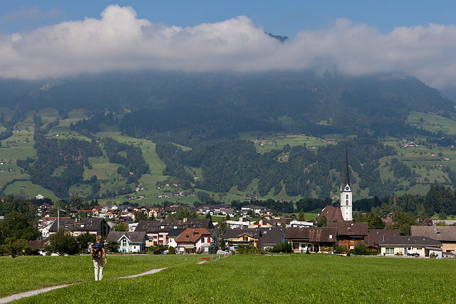
 Hiking in Obwalden
The Canton of Obwalden, located in central Switzerland, is a spectacular area for hiking, characterized by its stunning Alpine landscapes, lush green valleys, and clear lakes. Here are some key highlights and tips for hiking in this beautiful canton:
Scenic Trails
-
Pilatus: The Pilatus mountain offers several marked trails with varying difficulty levels. You can take the cogwheel train or cable car up and choose from easier walks or more challenging hikes. The views from the summit are breathtaking.
-
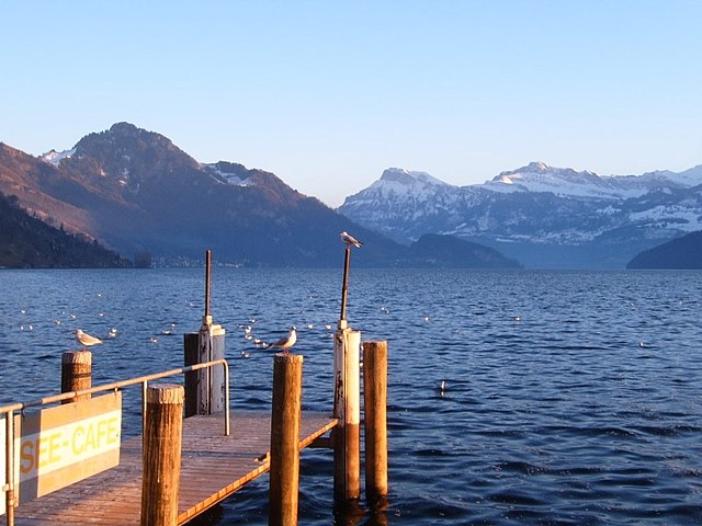
Lake Sarnen: The area around Lake Sarnen features scenic trails that offer both lakeside views and mountain backdrops. The circular walk around the lake is relatively flat and perfect for families.
-
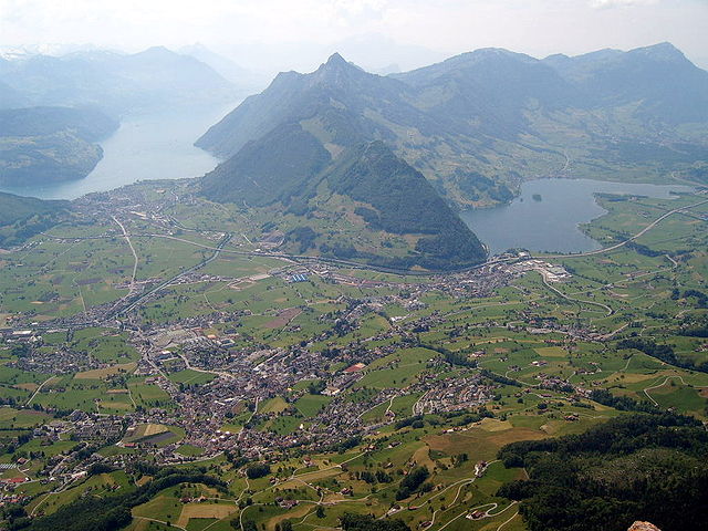
Kerns to Engelberg: This trail leads you through beautiful landscapes with fantastic views of the surrounding Alps. It’s a great way to experience the diverse flora and fauna of the region.
-
Brünig Pass: This area offers several hiking routes, including access to the scenic views of both Lake Brienz and Lake Lungern.
-
Hiking in the Hochstollen Nature Reserve: This area is perfect for those looking for less traveled paths and an opportunity to see local wildlife.
Tips for Hiking in Obwalden
-
Trail Marking: Trails are well-marked with the Swiss hiking trail signs. Always follow the red and white signs that indicate hiking paths.
-
Weather: Mountain weather can change rapidly. Always check conditions before heading out, and dress in layers.
-
Gear: Sturdy hiking boots and adequate clothing are essential. Bring a map or download local hiking apps for navigation.
-
Local Regulations: Be aware of local rules and guidelines regarding wildlife and natural preservation, especially in protected areas.
-
Hydration and Snacks: Carry enough water and snacks, especially on longer hikes, as facilities may not be available on the trails.
-
Guided Tours: If you are new to the area or hiking in general, consider joining a guided hiking tour for a more thorough exploration of the region.
Accessibility
Most of the popular hiking areas in Obwalden are accessible by public transport, making it easy to reach trailheads from major cities like Lucerne or Interlaken.
Conclusion
Whether you're an experienced hiker or just looking to enjoy a leisurely walk in nature, the Canton of Obwalden offers a range of options that cater to all levels. With its dramatic landscapes and tranquil settings, it’s a fantastic destination for outdoor enthusiasts.
- Country:

- Capital: Sarnen
- Licence Plate Code: OW
- Coordinates: 46° 52' 0" N, 8° 2' 0" E


- GPS tracks (wikiloc): [Link]
- AboveSeaLevel: 473 м m
- Area: 490.58 sq km
- Population: 37378
- Web site: http://www.ow.ch
- Wikipedia en: wiki(en)
- Wikipedia: wiki(de)
- Wikidata storage: Wikidata: Q12573
- Wikipedia Commons Gallery: [Link]
- Wikipedia Commons Category: [Link]
- Freebase ID: [/m/01v1kf]
- GeoNames ID: Alt: [2659315]
- BnF ID: [12071287k]
- VIAF ID: Alt: [128415750]
- GND ID: Alt: [4078653-5]
- archINFORM location ID: [5880]
- Library of Congress authority ID: Alt: [n80124947]
- MusicBrainz area ID: [60f0c1c9-13ee-4d6c-96e2-42824e596be1]
- Quora topic ID: [Canton-of-Obwalden]
- TGN ID: [7003754]
- SUDOC authorities ID: [028992547]
- Encyclopædia Britannica Online ID: [place/Obwalden]
- Gran Enciclopèdia Catalana ID: [0046763]
- HDS ID: [7410]
- ISNI: Alt: [0000 0001 1498 4918]
- NUTS code: [CH064]
- Ringgold ID: [322126]
- STW Thesaurus for Economics ID: [16969-4]
- ISO 3166-2 code: CH-OW
- FIPS 10-4 (countries and regions): SZ14
Includes regions:


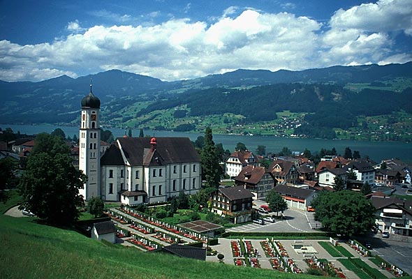
Sarnen
- town in, and capital of, the Swiss canton of Obwalden
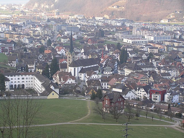
Hiking in Sarnen
Sarnen, located in the Canton of Obwalden in Switzerland, is a picturesque destination for hiking enthusiasts. Nestled between beautiful mountains and a tranquil lake, Sarnen offers a variety of hiking trails suitable for different skill levels, making it an ideal spot for both beginners and experienced hikers....
- Country:
- Postal Code: 6060
- Local Dialing Code: 041
- Licence Plate Code: OW
- Coordinates: 46° 53' 49" N, 8° 14' 49" E
- GPS tracks (wikiloc): [Link]
- AboveSeaLevel: 1309 м m
- Area: 70.01 sq km
- Population: 10233
- Web site: [Link]


Engelberg
- municipality in Switzerland
Hiking in Engelberg
Engelberg is a picturesque mountain village located in Switzerland, nestled in the heart of the Swiss Alps. It’s renowned for its stunning landscapes, fantastic hiking trails, and as a starting point for various outdoor activities. Here are some highlights of hiking in Engelberg:...
- Country:
- Postal Code: 6390
- Local Dialing Code: 041
- Licence Plate Code: OW
- Coordinates: 46° 49' 11" N, 8° 26' 3" E
- GPS tracks (wikiloc): [Link]
- AboveSeaLevel: 1419 м m
- Area: 40.75 sq km
- Population: 4155
- Web site: [Link]


Lungern
- municipality in Switzerland
Hiking in Lungern
Lungern is a beautiful village situated in the Swiss canton of Obwalden, nestled between the spectacular mountains and alongside the pristine Lungern-Turren Lake. The area offers a variety of hiking opportunities that cater to different skill levels, making it an excellent destination for both casual walkers and seasoned hikers. Here are some highlights of hiking in Lungern:...
- Country:
- Postal Code: 6078
- Local Dialing Code: 041
- Licence Plate Code: OW
- Coordinates: 46° 47' 14" N, 8° 9' 35" E
- GPS tracks (wikiloc): [Link]
- AboveSeaLevel: 716 м m
- Area: 46.47 sq km
- Population: 2122
- Web site: [Link]

Sachseln
- municipality in Switzerland
Hiking in Sachseln
Sachseln is a beautiful village located in the Obwalden region of Switzerland, near the stunning Lake Sarnen and close to the city of Lucerne. Hiking in and around Sachseln offers a mix of scenic landscapes, cultural experiences, and opportunities for outdoor adventure....
- Country:
- Postal Code: 6072
- Local Dialing Code: 041
- Licence Plate Code: OW
- Coordinates: 46° 52' 4" N, 8° 14' 19" E
- GPS tracks (wikiloc): [Link]
- AboveSeaLevel: 1634 м m
- Area: 53.86 sq km
- Population: 5092
- Web site: [Link]

Kerns
- village in the canton of Obwalden, Switzerland
Hiking in Kerns
Kerns is a picturesque area in Utah, known for its stunning landscapes and outdoor recreation opportunities, including hiking. Here are some key points about hiking in Kerns:...
- Country:
- Postal Code: 6064
- Local Dialing Code: 041
- Licence Plate Code: OW
- Coordinates: 46° 50' 23" N, 8° 18' 5" E
- GPS tracks (wikiloc): [Link]
- AboveSeaLevel: 1017 м m
- Area: 92.58 sq km
- Population: 6295
- Web site: [Link]

Giswil
- municipality in the canton of Obwalden in Switzerland
Hiking in Giswil
Giswil is a beautiful village located in the Canton of Obwalden in Switzerland, surrounded by stunning mountains and offering a variety of hiking opportunities. Here are some highlights of hiking in and around Giswil:...
- Country:
- Postal Code: 6074
- Local Dialing Code: 041
- Licence Plate Code: OW
- Coordinates: 46° 50' 9" N, 8° 7' 8" E
- GPS tracks (wikiloc): [Link]
- AboveSeaLevel: 1237 м m
- Area: 85.96 sq km
- Population: 3651
- Web site: [Link]

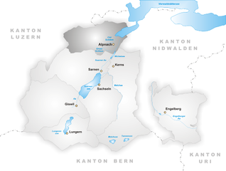
Alpnach
- municipality in Switzerland
Hiking in Alpnach
Alpnach, located in central Switzerland near Lake Alpnach and the foothills of the Swiss Alps, offers a range of hiking opportunities for outdoor enthusiasts. The area features stunning natural beauty, from lush forests and rolling hills to breathtaking alpine views....
- Country:
- Postal Code: 6055
- Local Dialing Code: 041
- Licence Plate Code: OW
- Coordinates: 46° 57' 0" N, 8° 13' 51" E
- GPS tracks (wikiloc): [Link]
- AboveSeaLevel: 1039 м m
- Area: 56.98 sq km
- Population: 6024
- Web site: [Link]
Shares border with regions:

canton of Bern
- canton of Switzerland
Hiking in canton of Bern
The Canton of Bern, located in Switzerland, offers some of the most stunning landscapes and diverse trails for hiking enthusiasts. This region boasts a mix of alpine scenery, picturesque villages, and lush valleys, making it an excellent destination for all levels of hikers. Here are some highlights you can expect when hiking in the Canton of Bern:...
- Country:
- Capital: Bern
- Licence Plate Code: BE
- Coordinates: 46° 50' 0" N, 7° 37' 0" E
- GPS tracks (wikiloc): [Link]
- AboveSeaLevel: 542 м m
- Area: 5959 sq km
- Population: 1031126
- Web site: [Link]

Canton of Lucerne
- canton of Switzerland
Hiking in Canton of Lucerne
Hiking in the Canton of Lucerne, located in central Switzerland, offers a diverse range of trails that showcase stunning landscapes, picturesque lakes, and the majestic Alps. Here are some highlights and tips for hiking in this beautiful region:...
- Country:
- Capital: Lucerne
- Licence Plate Code: LU
- Coordinates: 47° 5' 0" N, 8° 7' 0" E
- GPS tracks (wikiloc): [Link]
- AboveSeaLevel: 436 м m
- Area: 1493.51 sq km
- Web site: [Link]


Uri
- canton of Switzerland
Hiking in Uri
The Canton of Uri, situated in central Switzerland, offers stunning landscapes and a range of hiking opportunities for all skill levels. Here’s a general overview of hiking in this picturesque region:...
- Country:
- Capital: Altdorf
- Licence Plate Code: UR
- Coordinates: 46° 47' 0" N, 8° 37' 0" E
- GPS tracks (wikiloc): [Link]
- AboveSeaLevel: 447 м m
- Area: 1076.57 sq km
- Population: 36145
- Web site: [Link]

Schwyz
- canton of Switzerland
Hiking in Schwyz
Hiking in the Canton of Schwyz in Switzerland offers a fantastic blend of stunning landscapes, rich cultural history, and well-maintained trails. The region features a variety of terrains, including mountains, lakes, and picturesque villages, making it a great destination for both novice and experienced hikers....
- Country:
- Capital: Schwyz
- Licence Plate Code: SZ
- Coordinates: 47° 4' 0" N, 8° 45' 0" E
- GPS tracks (wikiloc): [Link]
- AboveSeaLevel: 516 м m
- Area: 907.88 sq km
- Population: 155863
- Web site: [Link]

Nidwalden
- canton of Switzerland
Hiking in Nidwalden
The Canton of Nidwalden, located in central Switzerland, is a true paradise for hikers, offering breathtaking landscapes, diverse trails, and stunning vistas of the surrounding mountains and lakes. Here are some highlights and points of interest for hiking in this beautiful region:...
- Country:
- Capital: Stans
- Licence Plate Code: NW
- Coordinates: 46° 56' 0" N, 8° 4' 0" E
- GPS tracks (wikiloc): [Link]
- AboveSeaLevel: 454 м m
- Area: 275.85 sq km
- Web site: [Link]