Cervières (Cervières)
- commune in Hautes-Alpes, France
 Hiking in Cervières
Cervières is a picturesque valley located in the Hautes-Alpes region of France, renowned for its stunning natural beauty, diverse landscapes, and rich cultural heritage. It offers a variety of hiking opportunities suited for all levels, from casual strolls to more challenging treks. Here are some highlights of hiking in this area:
Trails and Routes
-
Les Aiguilles de Chorges: This trail provides spectacular views and takes you through diverse terrain, including alpine meadows and rocky paths. It’s ideal for those looking for a moderate challenge.
-
Col des Aiguilles: This high mountain pass offers breathtaking panoramas of the surrounding peaks and valleys. The ascent may be steep in sections, but the views are well worth the effort.
-
Larch Forest Trails: For a more relaxed experience, explore the trails that wind through the charming larch forests of Cervières. These paths are perfect for families and those who enjoy a leisurely walk amidst nature.
-
Sentier des Gorges de la Cerveyrette: A beautiful path that runs along the Cerveyrette River, this hike features scenic waterfalls and interesting rock formations. It’s accessible and a great choice for all hikers.
Best Time to Hike
The best time for hiking in Cervières is typically from late spring (May) to early autumn (October). The weather is usually mild and the trails are accessible, allowing hikers to enjoy the natural beauty without harsh conditions. However, conditions can vary, so checking local forecasts and trail statuses is essential.
Preparing for Your Hike
- Footwear: Good hiking boots are necessary for navigating the varied terrain.
- Weather: Dress in layers and prepare for sudden weather changes, especially in higher altitudes.
- Supplies: Bring plenty of water, snacks, and a first-aid kit. A map or GPS device is recommended, as some trails may not be well-marked.
- Wildlife: Keep an eye out for local wildlife and respect their habitats.
Local Culture
Cervières is not only a place for hiking; it also has a rich cultural heritage. The village is known for its traditional architecture, including stone houses and chapels. Take the time to explore the local culture, cuisine, and history during your visit.
Hiking in Cervières offers a perfect blend of adventure, breathtaking scenery, and cultural exploration. Whether you’re looking for a challenging trek or a peaceful walk, the region has something to offer every hiker. Enjoy your adventure!
- Country:

- Postal Code: 05100
- Coordinates: 44° 52' 11" N, 6° 43' 19" E


- GPS tracks (wikiloc): [Link]
- Area: 109.68 sq km
- Population: 183
- Wikipedia en: wiki(en)
- Wikipedia: wiki(fr)
- Wikidata storage: Wikidata: Q1030369
- Wikipedia Commons Category: [Link]
- Freebase ID: [/m/03m8143]
- Freebase ID: [/m/03m8143]
- GeoNames ID: Alt: [6454916]
- GeoNames ID: Alt: [6454916]
- SIREN number: [210500278]
- SIREN number: [210500278]
- PACTOLS thesaurus ID: [pcrteeQqBPXzHT]
- PACTOLS thesaurus ID: [pcrteeQqBPXzHT]
- INSEE municipality code: 05027
- INSEE municipality code: 05027
Shares border with regions:

Château-Ville-Vieille
- commune in Hautes-Alpes, France
Hiking in Château-Ville-Vieille
Château-Ville-Vieille, located in the picturesque region of the Queyras in the French Alps, is an excellent destination for hiking enthusiasts. This charming village is situated at a high altitude and offers stunning views of the surrounding mountains, valleys, and the natural beauty of the Alps....
- Country:
- Postal Code: 05350
- Coordinates: 44° 45' 24" N, 6° 47' 28" E
- GPS tracks (wikiloc): [Link]
- Area: 66.9 sq km
- Population: 338

Arvieux
- commune in Hautes-Alpes, France
Hiking in Arvieux
Arvieux is a stunning destination situated in the Queyras Regional Natural Park in the French Alps, known for its beautiful landscapes, charming villages, and numerous hiking trails. Here are some highlights and tips for hiking in Arvieux:...
- Country:
- Postal Code: 05350
- Coordinates: 44° 46' 0" N, 6° 44' 20" E
- GPS tracks (wikiloc): [Link]
- Area: 72.62 sq km
- Population: 363

Val-des-Prés
- commune in Hautes-Alpes, France
Hiking in Val-des-Prés
Val-des-Prés is a picturesque commune located in the Alpes-de-Haute-Provence region of France, known for its stunning landscapes and outdoor recreational opportunities, particularly hiking. Here are some key points to consider if you're planning to hike in Val-des-Prés:...
- Country:
- Postal Code: 05100
- Coordinates: 44° 56' 54" N, 6° 40' 42" E
- GPS tracks (wikiloc): [Link]
- Area: 44.77 sq km
- Population: 656
- Web site: [Link]

Briançon
- commune in Hautes-Alpes, France
Hiking in Briançon
Briançon, located in the French Alps, is renowned for its stunning natural beauty and rich history. It sits at an elevation of about 1,326 meters (4,347 feet) and is surrounded by impressive mountain ranges, making it an ideal destination for hiking enthusiasts....
- Country:
- Postal Code: 05100
- Coordinates: 44° 53' 45" N, 6° 38' 6" E
- GPS tracks (wikiloc): [Link]
- AboveSeaLevel: 1325 м m
- Area: 28.07 sq km
- Population: 12370
- Web site: [Link]

Abriès
- commune in Hautes-Alpes, France
Hiking in Abriès
Abriès is a charming alpine village located in the Queyras Regional Natural Park in the French Alps. It is an excellent destination for hiking enthusiasts due to its stunning landscapes, diverse flora and fauna, and a variety of trails suitable for all levels of hikers. Here's an overview of what you can expect when hiking in Abriès:...
- Country:
- Postal Code: 05460
- Coordinates: 44° 47' 43" N, 6° 55' 38" E
- GPS tracks (wikiloc): [Link]
- Area: 77.13 sq km
- Population: 306
- Web site: [Link]

Aiguilles
- commune in Hautes-Alpes, France
Hiking in Aiguilles
Aiguilles, located in the French Alps, is a breathtaking area known for its dramatic peaks, stunning landscapes, and diverse hiking opportunities. Here’s a guide to hiking in this beautiful region:...
- Country:
- Postal Code: 05470
- Coordinates: 44° 46' 54" N, 6° 52' 8" E
- GPS tracks (wikiloc): [Link]
- Area: 40.16 sq km
- Population: 425

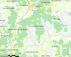
Villar-Saint-Pancrace
- commune in Hautes-Alpes, France
Hiking in Villar-Saint-Pancrace
Villar-Saint-Pancrace is a charming alpine village located in the Provence-Alpes-Côte d'Azur region of France, near the town of Briançon. The area is known for its stunning landscapes, rich biodiversity, and a variety of hiking trails that cater to different skill levels. Here are some highlights for hiking in this region:...
- Country:
- Postal Code: 05100
- Coordinates: 44° 52' 23" N, 6° 37' 38" E
- GPS tracks (wikiloc): [Link]
- AboveSeaLevel: 1260 м m
- Area: 42.53 sq km
- Population: 1457


Cesana Torinese
- Italian comune
Hiking in Cesana Torinese
Cesana Torinese is a picturesque village located in the Susa Valley in the Piedmont region of Italy, within the Italian Alps. Known for its stunning natural beauty, it offers a variety of hiking opportunities for all skill levels. Here are some key highlights and tips for hiking in this area:...
- Country:

- Postal Code: 10054
- Local Dialing Code: 0122
- Licence Plate Code: TO
- Coordinates: 44° 57' 0" N, 6° 48' 0" E
- GPS tracks (wikiloc): [Link]
- AboveSeaLevel: 1354 м m
- Area: 121.7 sq km
- Population: 945
- Web site: [Link]

Montgenèvre
- commune in Hautes-Alpes, France
Hiking in Montgenèvre
Montgenèvre is a charming village located in the French Alps, right near the Italian border, and it's an excellent destination for hiking enthusiasts. The landscape is characterized by breathtaking mountain views, lush valleys, and a range of trails suitable for various skill levels. Here are some key points about hiking in Montgenèvre:...
- Country:
- Postal Code: 05100
- Coordinates: 44° 55' 51" N, 6° 43' 16" E
- GPS tracks (wikiloc): [Link]
- AboveSeaLevel: 1860 м m
- Area: 40.07 sq km
- Population: 510
- Web site: [Link]