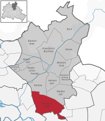
Lichtenberg (Lichtenberg)

- locality of borough Lichtenberg of Berlin, Germany
 Hiking in Lichtenberg
Lichtenberg is a picturesque locality located in the region of Brandenburg, Germany. It is situated near the capital city, Berlin, making it a popular destination for day-trippers and hikers looking to escape the urban environment.
Hiking Opportunities:
-
Scenic Trails: The area around Lichtenberg typically features a mix of forested areas, fields, and small lakes, which offer a variety of trails suited for different skill levels. The trails can range from easy walks for families to more challenging hikes suitable for seasoned trekkers.
-
Local Nature Reserves: Nearby nature reserves and parks provide opportunities for both hiking and wildlife observation. You may encounter various bird species and local flora.
-
Historic Paths: Some trails may also lead to historical sites or viewpoints, allowing hikers to combine nature with a bit of culture. Be sure to check maps and trail markers for interesting landmarks.
-
Community and Guided Hikes: Look for local organizations that offer guided hikes in the area. This can be a great way to learn more about the local ecosystem, history, and tips for hiking in the region.
-
Accessibility: Being close to Berlin, Lichtenberg is accessible via public transport, making it easy for those traveling from the city. Just ensure to check the latest transit schedules for reliability.
Preparation Tips:
- Weather: Before heading out, check the local weather conditions for safe hiking.
- Gear: Wear appropriate hiking footwear and clothing, and bring essentials such as water, snacks, a map, and a first-aid kit.
- Safety: Always let someone know your hiking plans and expected return time.
Conclusion:
Whether you’re looking for a leisurely stroll or a more challenging hike, the areas around Lichtenberg offer beautiful scenery and the chance to connect with nature. Enjoy your hike!
- Country:

- Coordinates: 52° 31' 16" N, 13° 28' 48" E


- GPS tracks (wikiloc): [Link]
- AboveSeaLevel: 52 м m
- Area: 7.22 sq km
- Population: 39121
- Wikipedia en: wiki(en)
- Wikipedia: wiki(de)
- Wikidata storage: Wikidata: Q9169094
- Wikipedia Commons Gallery: [Link]
- Wikipedia Commons Category: [Link]
- Wikipedia Commons Maps Category: [Link]
- Freebase ID: [/m/05zlln8]
- GeoNames ID: Alt: [2878102]
- OSM relation ID: [409206]
- GND ID: Alt: [4104503-8]
- archINFORM location ID: [43218]
- Library of Congress authority ID: Alt: [n94049515]
Shares border with regions:

Prenzlauer Berg
- locality of Berlin
Hiking in Prenzlauer Berg
Prenzlauer Berg, a vibrant district in Berlin, is primarily known for its urban environment, charming architecture, and lively atmosphere rather than traditional hiking trails. However, there are plenty of opportunities for enjoyable walks and exploration in this area. Here are some aspects to consider if you're looking to hike or walk in Prenzlauer Berg:...
- Country:
- Coordinates: 52° 32' 3" N, 13° 25' 7" E
- GPS tracks (wikiloc): [Link]
- AboveSeaLevel: 54 м m
- Area: 11 sq km
- Population: 156910


Friedrichshain
- locality of Berlin
Hiking in Friedrichshain
Friedrichshain is a vibrant neighborhood in Berlin, Germany, known more for its urban atmosphere, parks, and nightlife than for traditional hiking trails. However, there are still plenty of opportunities for walking and enjoying the outdoors in this area....
- Country:
- Postal Code: 10317; 10179; 10178; 10249; 10247; 10245; 10243
- Coordinates: 52° 30' 57" N, 13° 27' 15" E
- GPS tracks (wikiloc): [Link]
- AboveSeaLevel: 41 м m
- Area: 9.78 sq km
- Population: 125169


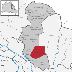
Rummelsburg
- locality of Berlin
Hiking in Rummelsburg
Rummelsburg is a neighborhood in Berlin, Germany, known more for its urban environment than traditional hiking trails. However, if you're looking for hiking-like experiences in and around Rummelsburg, there are a few options worth considering:...
- Country:
- Coordinates: 52° 30' 0" N, 13° 29' 33" E
- GPS tracks (wikiloc): [Link]
- AboveSeaLevel: 40 м m
- Area: 4.52 sq km
Friedrichsfelde
- locality of Berlin
Hiking in Friedrichsfelde
Friedrichsfelde is a district located in the eastern part of Berlin, Germany. It is known for its parkland and green spaces, making it a lovely area for hiking and outdoor activities. If you’re looking to hike in Friedrichsfelde, here are some details you might find useful:...
- Country:
- Coordinates: 52° 30' 21" N, 13° 31' 9" E
- GPS tracks (wikiloc): [Link]
- AboveSeaLevel: 39 м m
- Area: 5.55 sq km
- Population: 52502


Fennpfuhl
- locality of Berlin
Hiking in Fennpfuhl
Fennpfuhl is a neighborhood in Berlin, Germany, known more for urban exploration than traditional hiking. However, if you're looking for green spaces or walking routes, there are some nearby parks and pathways that can provide a nice urban escape....
- Country:
- Coordinates: 52° 31' 42" N, 13° 28' 27" E
- GPS tracks (wikiloc): [Link]
- AboveSeaLevel: 64 м m
- Area: 2.12 sq km


Alt-Hohenschönhausen
- locality of Berlin
Hiking in Alt-Hohenschönhausen
Alt-Hohenschönhausen, a district in the northeastern part of Berlin, Germany, may not be a traditional hiking destination, but it does offer some good opportunities for walking and exploring green spaces. Here are some points to consider if you're looking to hike or walk in this area:...
- Country:
- Coordinates: 52° 32' 55" N, 13° 30' 27" E
- GPS tracks (wikiloc): [Link]
- AboveSeaLevel: 55 м m
- Area: 9.33 sq km
- Population: 42609

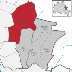
Marzahn
- locality of Berlin
Hiking in Marzahn
Marzahn, a district located in the northeastern part of Berlin, Germany, is not typically known as a hiking destination in the traditional sense, as it is more urbanized compared to other areas. However, there are still opportunities for walking and exploring nature in and around this district....
- Country:
- Postal Code: 12689; 12687; 12685; 12681; 12679
- Coordinates: 52° 32' 45" N, 13° 33' 45" E
- GPS tracks (wikiloc): [Link]
- AboveSeaLevel: 62 м m
- Area: 19.54 sq km
- Population: 106640