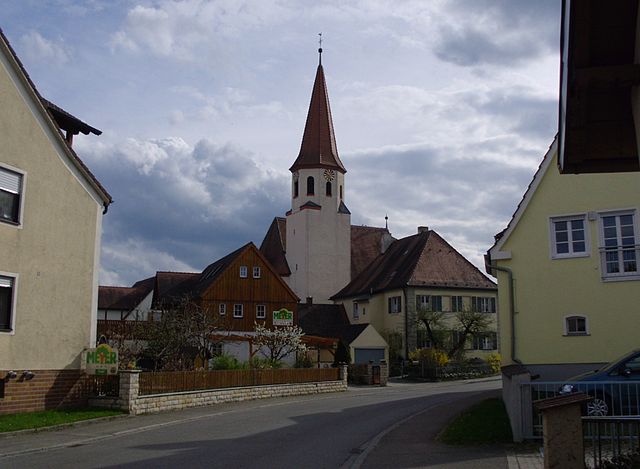
Gunzenhausen (Gunzenhausen)

- town in Bavaria, Germany
 Hiking in Gunzenhausen
Gunzenhausen is a charming town located in Bavaria, Germany, and serves as a gateway to some beautiful hiking opportunities, particularly around the Franconian Lake District (Fränkisches Seenland). Here’s what you can expect when hiking in and around Gunzenhausen:
Scenic Trails
-
Altmühl Valley Nature Park: Just a short distance from Gunzenhausen, this nature park offers numerous well-marked hiking trails. The Altmühl River meanders through picturesque landscapes, providing stunning views of rocky outcrops and lush greenery.
-
Franconian Lake District: This area is perfect for moderate hiking trails that often run alongside lakes such as Brombachsee and übersee. The trails are well-maintained and cater to hikers of all levels.
-
The Altmühl Panorama Trail: This longer-distance trail runs through the surrounding region, providing a mix of woodland paths, grasslands, and picturesque village views. It includes various segments that can be hiked as day hikes.
Local Attractions
- Historical Sites: As you hike, you may come across historic buildings, castles, and ruins that tell the story of the region's heritage. Don't miss the medieval charm of Gunzenhausen itself.
- Wildlife and Nature: Keep an eye out for diverse wildlife, as the area is home to many species, particularly along the riverbanks and in forested areas.
Tips for Hiking in Gunzenhausen
- Weather Preparations: Bavaria can have unpredictable weather, so make sure to check the local forecast and dress in layers. Waterproof gear can be useful.
- Hiking Maps: While many trails are well-marked, it can be helpful to have a map or a hiking app for navigation. Local tourist offices often provide free maps.
- Refreshments: Pack enough water and snacks for your hike, as not all trails will have facilities along the way. Consider stopping in nearby towns for a local meal or drink after your hike.
- Trail Etiquette: Always be respectful of nature and other hikers. Stay on marked paths and follow any posted rules regarding wildlife and plant life.
Accessibility
Gunzenhausen is well-connected by public transportation, making it accessible for day-trippers from Munich or Nuremberg. If you drive, there are ample parking spots near trailheads.
Conclusion
Hiking around Gunzenhausen offers a blend of natural beauty, recreational opportunities, and cultural experiences. It's a great destination for outdoor enthusiasts looking to explore the scenic landscapes of Bavaria. Whether you’re a seasoned hiker or just starting out, there’s something for everyone to enjoy in this scenic part of Germany.
- Country:

- Postal Code: 91710
- Local Dialing Code: 09836; 09831
- Coordinates: 49° 6' 53" N, 10° 45' 15" E


- GPS tracks (wikiloc): [Link]
- AboveSeaLevel: 416 м m
- Area: 82.72 sq km
- Population: 16562
- Web site: https://gunzenhausen.de/
- Wikipedia en: wiki(en)
- Wikipedia: wiki(de)
- Wikidata storage: Wikidata: Q503640
- Wikipedia Commons Category: [Link]
- GeoNames ID: Alt: [2913537]
- VIAF ID: Alt: [133702396]
- OSM relation ID: [1015096]
- GND ID: Alt: [4022556-2]
- archINFORM location ID: [13225]
- Library of Congress authority ID: Alt: [n81093630]
- TGN ID: [7012907]
- Gran Enciclopèdia Catalana ID: [0460629]
- Historical Gazetteer (GOV) ID: [GUNSE1JN59JC]
- Bavarikon ID: [ODB_A00000206]
- Pleiades ID: [118717]
- German municipality key: 09577136
Includes regions:

Aha
- human settlement in Germany
Hiking in Aha
Aha, a small district in Gunzenhausen, Germany, is surrounded by beautiful natural landscapes that offer a range of hiking opportunities. While the area is relatively quiet compared to popular hiking regions, it features scenic trails and paths that can be enjoyed by both beginner and experienced hikers....
- Country:
- Postal Code: 91710
- Local Dialing Code: 09831
- Coordinates: 49° 5' 48" N, 10° 45' 3" E
- GPS tracks (wikiloc): [Link]
- AboveSeaLevel: 416 м m

Pflaumfeld
- human settlement in Germany
Hiking in Pflaumfeld
Pflaumfeld is a charming small village located in the southern part of Germany, particularly within the region of Bavaria. While it may not be as widely recognized as some of the more popular hiking destinations, it offers some beautiful trails for outdoor enthusiasts....
- Country:
- Postal Code: 91710
- Local Dialing Code: 09831
- Coordinates: 49° 4' 38" N, 10° 44' 18" E
- GPS tracks (wikiloc): [Link]
- AboveSeaLevel: 445 м m
Unterwurmbach
- human settlement
Hiking in Unterwurmbach
Unterwurmbach is a beautiful area for hiking, located in the scenic landscape of Bavaria, Germany. Nestled in the foothills of the Alps, it offers a variety of hiking trails that cater to different skill levels, from leisurely walks to more challenging hikes....
- Country:
- Postal Code: 91710
- Local Dialing Code: 09831
- Coordinates: 49° 6' 22" N, 10° 43' 37" E
- GPS tracks (wikiloc): [Link]
- AboveSeaLevel: 420 м m
- Area: 8.6 sq km

Büchelberg
- human settlement in Germany
Hiking in Büchelberg
Büchelberg, located near Gunzenhausen in Bavaria, Germany, offers some beautiful hiking opportunities amidst picturesque landscapes. The region is characterized by its rolling hills, lush forests, and tranquil lakes, making it an ideal destination for nature lovers and hikers seeking both leisure and adventure....
- Country:
- Postal Code: 91710
- Local Dialing Code: 09831
- Coordinates: 49° 9' 18" N, 10° 44' 58" E
- GPS tracks (wikiloc): [Link]
- AboveSeaLevel: 437 м m

Cronheim
- human settlement in Germany
Hiking in Cronheim
I'm sorry, but I'm not familiar with a location called Cronheim specifically in relation to hiking. It’s possible that it might be a local or lesser-known area not widely documented in hiking resources....
- Country:
- Postal Code: 91710
- Local Dialing Code: 09836
- Coordinates: 49° 5' 44" N, 10° 39' 49" E
- GPS tracks (wikiloc): [Link]
- AboveSeaLevel: 478 м m
- Population: 500

Edersfeld
- human settlement in Germany
Hiking in Edersfeld
Edersfeld is a picturesque area that offers a variety of hiking opportunities, particularly known for its natural beauty and scenic landscapes. While specifics about Edersfeld might not be widely known, generally, regions like this often feature well-marked trails, diverse ecosystems, and stunning views....
- Country:
- Postal Code: 91710
- Local Dialing Code: 09831
- Coordinates: 49° 5' 32" N, 10° 43' 36" E
- GPS tracks (wikiloc): [Link]
- AboveSeaLevel: 437 м m

Filchenhard
- human settlement in Germany
Hiking in Filchenhard
Filchenhard is a small village located in Germany, known for its picturesque landscapes and proximity to nature. While specific information about hiking in Filchenhard may not be widely documented, the surrounding areas typically offer pleasant hiking opportunities....
- Country:
- Postal Code: 91710
- Local Dialing Code: 09836
- Coordinates: 49° 6' 5" N, 10° 41' 0" E
- GPS tracks (wikiloc): [Link]
- AboveSeaLevel: 441 м m

Frickenfelden
- human settlement in Germany
Hiking in Frickenfelden
Frickenfelden is a small village located in Germany, specifically in the state of Bavaria. While it may not be widely known as a hiking destination, the surrounding region offers beautiful landscapes and opportunities for outdoor activities, including hiking....
- Country:
- Postal Code: 91710
- Local Dialing Code: 09831
- Coordinates: 49° 7' 0" N, 10° 48' 2" E
- GPS tracks (wikiloc): [Link]
- AboveSeaLevel: 442 м m
- Area: 2.9855 sq km

Höhberg (Gunzenhausen)
- human settlement in Germany
Hiking in Höhberg (Gunzenhausen)
Höhberg, located near Gunzenhausen in Bavaria, Germany, is an excellent destination for hiking enthusiasts. The area is characterized by its picturesque landscapes, rolling hills, and lush forests, making it a great spot for both casual walkers and experienced hikers....
- Country:
- Postal Code: 91710
- Local Dialing Code: 09831
- Coordinates: 49° 8' 15" N, 10° 40' 40" E
- GPS tracks (wikiloc): [Link]
Laubenzedel
- human settlement in Germany
Hiking in Laubenzedel
Laubenzedel is a picturesque area that offers various hiking opportunities, particularly for those looking to explore natural beauty and enjoy the outdoors. While it may not be as widely recognized as some other hiking destinations, it can still provide an enjoyable experience surrounded by nature....
- Country:
- Postal Code: 91710
- Local Dialing Code: 09831
- Coordinates: 49° 8' 37" N, 10° 44' 59" E
- GPS tracks (wikiloc): [Link]
- AboveSeaLevel: 421 м m

Lindenhof (Gunzenhausen)
- human settlement in Germany
Hiking in Lindenhof (Gunzenhausen)
Lindenhof in Gunzenhausen, Germany, is a beautiful area for hiking, known for its picturesque landscapes and rich natural beauty. Here are some key points to consider if you are planning a hiking trip there:...
- Country:
- Postal Code: 91710
- Local Dialing Code: 09831
- Coordinates: 49° 6' 49" N, 10° 46' 44" E
- GPS tracks (wikiloc): [Link]
- AboveSeaLevel: 462 м m
Lohmühle
- human settlement in Germany
Hiking in Lohmühle
Lohmühle, located near Gunzenhausen in Bavaria, Germany, offers a variety of hiking opportunities amidst scenic landscapes and natural beauty. The region is characterized by its lush forests, rolling hills, and nearby lakes, making it an excellent destination for outdoor enthusiasts....
- Country:
- Postal Code: 91710
- Local Dialing Code: 09831
- Coordinates: 49° 6' 0" N, 10° 46' 27" E
- GPS tracks (wikiloc): [Link]
- AboveSeaLevel: 430 м m

Maicha
- human settlement in Germany
Hiking in Maicha
Maicha, a stunning destination for hikers, offers diverse landscapes ranging from lush forests to rocky terrains, making it ideal for various skill levels. Here are some things to keep in mind if you’re planning a hiking trip in Maicha:...
- Country:
- Postal Code: 91710
- Local Dialing Code: 09836
- Coordinates: 49° 5' 38" N, 10° 41' 41" E
- GPS tracks (wikiloc): [Link]
- AboveSeaLevel: 440 м m

Mooskorb
- human settlement in Germany
Hiking in Mooskorb
It looks like there might be a little confusion because "Mooskorb" doesn't appear to be a widely recognized hiking destination. However, if you meant to refer to a different location or a specific region, please clarify, and I’d be glad to provide information about hiking there....
- Country:
- Postal Code: 91710
- Local Dialing Code: 09831
- Coordinates: 49° 8' 0" N, 10° 42' 3" E
- GPS tracks (wikiloc): [Link]
- AboveSeaLevel: 419 м m

Nordstetten
- human settlement in Germany
Hiking in Nordstetten
Nordstetten, a district of Gunzenhausen in Bavaria, Germany, is situated near the scenic Altmühltal Nature Park. This area is known for its beautiful landscapes, diverse flora and fauna, and well-maintained hiking trails. Here are some highlights and tips for hiking in and around Nordstetten:...
- Country:
- Postal Code: 91710
- Local Dialing Code: 09836
- Coordinates: 49° 4' 36" N, 10° 42' 25" E
- GPS tracks (wikiloc): [Link]
- AboveSeaLevel: 439 м m

Obenbrunn
- human settlement in Germany
Hiking in Obenbrunn
Obenbrunn is a scenic area that can be ideal for hiking enthusiasts looking for beautiful landscapes and a peaceful atmosphere. While specific trails may vary, areas like Obenbrunn typically offer a mix of forested paths, meadows, and perhaps some rolling hills, making for enjoyable hiking experiences....
- Country:
- Postal Code: 91710
- Local Dialing Code: 09836
- Coordinates: 49° 6' 19" N, 10° 48' 0" E
- GPS tracks (wikiloc): [Link]

Oberasbach (Gunzenhausen)
- human settlement in Germany
Hiking in Oberasbach (Gunzenhausen)
Oberasbach, located near Gunzenhausen in Bavaria, Germany, offers a delightful setting for hiking enthusiasts. The region is characterized by its picturesque landscapes, including rolling hills, forests, and scenic views of nearby lakes and rivers, notably the Altmühl River....
- Country:
- Postal Code: 91710
- Local Dialing Code: 09831
- Coordinates: 49° 6' 15" N, 10° 47' 12" E
- GPS tracks (wikiloc): [Link]
- AboveSeaLevel: 472 м m

Oberhambach
- human settlement in Germany
Hiking in Oberhambach
Oberhambach, located near Gunzenhausen in Bavaria, Germany, is a charming area for hiking enthusiasts. The region is characterized by its picturesque landscapes, rolling hills, and scenic trails that provide a mix of natural beauty and tranquility....
- Country:
- Postal Code: 91710
- Local Dialing Code: 09836
- Coordinates: 49° 7' 31" N, 10° 40' 6" E
- GPS tracks (wikiloc): [Link]
- AboveSeaLevel: 438 м m

Oberwurmbach
- human settlement
Hiking in Oberwurmbach
Oberwurmbach is a picturesque area that is perfect for hiking enthusiasts looking to explore natural landscapes. While specific trails and routes may vary, I can provide you with general tips and highlights that typically characterize hiking in areas like Oberwurmbach....
- Country:
- Postal Code: 91710
- Local Dialing Code: 09831
- Coordinates: 49° 6' 4" N, 10° 42' 51" E
- GPS tracks (wikiloc): [Link]
- AboveSeaLevel: 423 м m
Reutberg
- human settlement in Germany
Hiking in Reutberg
Reutberg, located near Gunzenhausen in Bavaria, Germany, is part of the picturesque Franconian Lake District. This area offers a wonderful blend of natural beauty, well-marked hiking trails, and opportunities for outdoor activities....
- Country:
- Postal Code: 91710
- Local Dialing Code: 09836
- Coordinates: 49° 6' 29" N, 10° 46' 24" E
- GPS tracks (wikiloc): [Link]

Scheupeleinsmühle
- human settlement in Germany
Hiking in Scheupeleinsmühle
Scheupeleinsmühle is a picturesque area located in Germany, known for its lovely landscapes, trails, and natural beauty. Hiking in this region can offer a serene experience, combining scenic views, lush forests, and the charm of historical sites....
- Country:
- Postal Code: 91710
- Local Dialing Code: 09831
- Coordinates: 49° 6' 47" N, 10° 44' 56" E
- GPS tracks (wikiloc): [Link]

Schlungenhof
- human settlement in Germany
Hiking in Schlungenhof
Schlungenhof is a picturesque village located in the beautiful Bavarian region of Germany, surrounded by stunning landscapes that make it a great spot for hiking enthusiasts. While specific marked trails may vary, the general area offers a variety of hiking opportunities suitable for different skill levels....
- Country:
- Postal Code: 91710
- Local Dialing Code: 09831
- Coordinates: 49° 7' 50" N, 10° 44' 34" E
- GPS tracks (wikiloc): [Link]
- AboveSeaLevel: 415 м m
Schnackenmühle (Gunzenhausen)
- human settlement in Germany
Hiking in Schnackenmühle (Gunzenhausen)
Schnackenmühle, located near Gunzenhausen in Bavaria, Germany, is a great spot for hiking enthusiasts. The area is known for its beautiful natural landscapes, forests, and proximity to the Altmühl Valley Nature Park, which offers various trails for different skill levels....
- Country:
- Postal Code: 91710
- Local Dialing Code: 09831
- Coordinates: 49° 8' 54" N, 10° 46' 0" E
- GPS tracks (wikiloc): [Link]
Schweina
- human settlement in Germany
Hiking in Schweina
Schweina, located near Gunzenhausen in Bavaria, Germany, is a fantastic destination for hiking enthusiasts. Known for its picturesque landscapes, diverse trails, and serene nature, it offers an excellent experience for both beginners and experienced hikers....
- Country:
- Postal Code: 91710
- Local Dialing Code: 09831
- Coordinates: 49° 8' 0" N, 10° 43' 0" E
- GPS tracks (wikiloc): [Link]
- AboveSeaLevel: 428 м m
Sinderlach
- human settlement in Germany
Hiking in Sinderlach
Sinderlach is not a widely recognized hiking destination, so it’s possible you may be referring to a lesser-known area or a specific local spot that has yet to gain broader popularity. If you can provide some additional context about Sinderlach, such as its geographical location or nearby landmarks, I would be more than happy to help you with specific hiking information....
- Country:
- Postal Code: 91710
- Local Dialing Code: 09831
- Coordinates: 49° 8' 13" N, 10° 45' 58" E
- GPS tracks (wikiloc): [Link]
- AboveSeaLevel: 424 м m

Steinabühl
- human settlement in Germany
Hiking in Steinabühl
Steinabühl is not a widely recognized hiking destination, but it could be a local or specific region that may offer some great hiking opportunities. However, based on the name, it's likely in a mountainous or hilly area, which often provides beautiful landscapes, diverse flora and fauna, and a range of trails....
- Country:
- Postal Code: 91710
- Local Dialing Code: 09831
- Coordinates: 49° 7' 41" N, 10° 41' 52" E
- GPS tracks (wikiloc): [Link]
- AboveSeaLevel: 420 м m

Steinacker
- human settlement in Germany
Hiking in Steinacker
Steinacker is a beautiful area near Gunzenhausen, situated in Bavaria, Germany. It offers a variety of hiking opportunities for nature lovers and outdoor enthusiasts. The region is characterized by its picturesque landscapes, rolling hills, and green meadows, making it an ideal location for a variety of hiking trails....
- Country:
- Postal Code: 91710
- Local Dialing Code: 09831
- Coordinates: 49° 4' 28" N, 10° 43' 10" E
- GPS tracks (wikiloc): [Link]
- AboveSeaLevel: 450 м m
Stetten
- human settlement in Germany
Hiking in Stetten
Stetten is a charming village located near Gunzenhausen in Bavaria, Germany. The area is known for its beautiful landscapes and numerous hiking trails that cater to a variety of skill levels. When hiking in Stetten and its surrounding regions, you can expect to enjoy scenic views, lush forests, and a peaceful atmosphere, making it a great destination for both casual walkers and more experienced hikers....
- Country:
- Postal Code: 91710
- Local Dialing Code: 09836
- Coordinates: 49° 4' 56" N, 10° 41' 2" E
- GPS tracks (wikiloc): [Link]
- AboveSeaLevel: 450 м m
Streudorf (Gunzenhausen)
- human settlement in Germany
Hiking in Streudorf (Gunzenhausen)
Streudorf, located near Gunzenhausen in Bavaria, Germany, is an excellent starting point for hiking enthusiasts looking to explore the beautiful landscapes of the Franconian region. While it's a small village, the surrounding area offers various trails and nature experiences. Here are some key points about hiking in Streudorf and the nearby environment:...
- Country:
- Postal Code: 91710
- Local Dialing Code: 09831
- Coordinates: 49° 8' 15" N, 10° 41' 25" E
- GPS tracks (wikiloc): [Link]
- AboveSeaLevel: 418 м m

Unterasbach
- human settlement in Germany
Hiking in Unterasbach
Unterasbach, a small village near Gunzenhausen in Bavaria, Germany, offers a lovely setting for hiking enthusiasts. Nestled in the peaceful Franconian countryside, the area is characterized by rolling hills, lush forests, and scenic farmland, making it ideal for outdoor exploration....
- Country:
- Postal Code: 91710
- Local Dialing Code: 09831
- Coordinates: 49° 5' 29" N, 10° 47' 12" E
- GPS tracks (wikiloc): [Link]
- AboveSeaLevel: 417 м m

Unterhambach
- human settlement in Germany
Hiking in Unterhambach
Unterhambach is a small village located in the picturesque region of Bavaria, Germany. While it may not be as well-known as some other hiking destinations, it offers beautiful landscapes and opportunities for outdoor exploration, especially for those who enjoy hiking in a serene and natural setting....
- Country:
- Postal Code: 91710
- Local Dialing Code: 09836
- Coordinates: 49° 6' 57" N, 10° 40' 55" E
- GPS tracks (wikiloc): [Link]
- AboveSeaLevel: 428 м m

Wald
- human settlement in Germany
Hiking in Wald
Wald, located near Gunzenhausen in Bavaria, Germany, is a beautiful area that offers a range of hiking opportunities. The landscape is characterized by scenic woodlands, rolling hills, and various trails suitable for all skill levels. Here are some key points about hiking in Wald and its surroundings:...
- Country:
- Postal Code: 91710
- Coordinates: 49° 7' 56" N, 10° 42' 26" E
- GPS tracks (wikiloc): [Link]
- AboveSeaLevel: 416 м m
Weinberg
- human settlement in Germany
Hiking in Weinberg
Weinberg, located near Gunzenhausen in Bavaria, Germany, offers a picturesque hiking experience. The region is known for its rolling hills, lush forests, and scenic views, making it a great destination for nature lovers and outdoor enthusiasts. Here are some key points about hiking in the area:...
- Country:
- Postal Code: 91710
- Local Dialing Code: 09836
- Coordinates: 49° 6' 19" N, 10° 46' 19" E
- GPS tracks (wikiloc): [Link]
Shares border with regions:

Ansbach
- district in Bavaria, Germany
Hiking in Ansbach
Ansbach district, located in the region of Bavaria, Germany, offers a variety of hiking opportunities suitable for different skill levels. The region is characterized by its picturesque landscapes, including rolling hills, forests, and historical sites, making it a great destination for outdoor enthusiasts....
- Country:
- Capital: Ansbach
- Licence Plate Code: ROT; FEU; DKB; AN
- Coordinates: 49° 19' 48" N, 10° 30' 0" E
- GPS tracks (wikiloc): [Link]
- AboveSeaLevel: 426 м m
- Area: 1972.00 sq km
- Population: 157632
- Web site: [Link]
Unterer Wald
- unincorporated in Germany
Hiking in Unterer Wald
Unterer Wald is a beautiful area known for its scenic landscapes and hiking opportunities. Here are some details that may enhance your hiking experience:...
- Country:
- Coordinates: 49° 8' 21" N, 10° 38' 31" E
- GPS tracks (wikiloc): [Link]

Muhr am See
- municipality of Germany
Hiking in Muhr am See
Muhr am See, located in Bavaria, Germany, is a picturesque destination that offers a variety of outdoor activities, including hiking. The area is characterized by its beautiful landscapes, tranquil lakes, and lush forests, making it an ideal place for nature enthusiasts....
- Country:
- Postal Code: 91735
- Local Dialing Code: 09831
- Licence Plate Code: WUG
- Coordinates: 49° 9' 16" N, 10° 43' 6" E
- GPS tracks (wikiloc): [Link]
- AboveSeaLevel: 422 м m
- Area: 10.95 sq km
- Population: 2223
- Web site: [Link]


Unterschwaningen
- municipality in Bavaria, Germany
Hiking in Unterschwaningen
Unterschwaningen is a charming village located in Bavaria, Germany, offering beautiful natural landscapes that are perfect for hiking enthusiasts. The region is characterized by rolling hills, lush forests, and picturesque meadows, making it an attractive destination for those looking to explore the outdoors....
- Country:
- Postal Code: 91743
- Local Dialing Code: 09836
- Licence Plate Code: AN
- Coordinates: 49° 4' 0" N, 10° 37' 0" E
- GPS tracks (wikiloc): [Link]
- AboveSeaLevel: 440 м m
- Area: 18.57 sq km
- Population: 858
- Web site: [Link]


Wassertrüdingen
- town in Germany
Hiking in Wassertrüdingen
Wassertrüdingen is a charming town in Bavaria, Germany, surrounded by beautiful countryside that offers plenty of opportunities for hiking enthusiasts. Here are some highlights and tips for hiking in and around Wassertrüdingen:...
- Country:
- Postal Code: 91717
- Local Dialing Code: 0 98 32
- Licence Plate Code: AN
- Coordinates: 49° 2' 0" N, 10° 36' 0" E
- GPS tracks (wikiloc): [Link]
- AboveSeaLevel: 423 м m
- Area: 53.58 sq km
- Population: 5600
- Web site: [Link]


Arberg
- municipality of Germany
Hiking in Arberg
Arberg is a small town located in the Franconia region of Bavaria, Germany. While it may not be as widely known for its hiking trails as larger national parks, it still offers opportunities for outdoor enthusiasts to explore the scenic beauty of the surrounding areas....
- Country:
- Postal Code: 91722
- Local Dialing Code: 09822
- Licence Plate Code: AN
- Coordinates: 49° 8' 0" N, 10° 37' 0" E
- GPS tracks (wikiloc): [Link]
- AboveSeaLevel: 468 м m
- Area: 31.31 sq km
- Population: 2007
- Web site: [Link]


Theilenhofen
- municipality of Germany
Hiking in Theilenhofen
Theilenhofen, located in Bavaria, Germany, offers beautiful scenic landscapes that are perfect for hiking enthusiasts. The region features a mix of natural beauty, charming villages, and a rich cultural heritage, making it a great destination for outdoor activities....
- Country:
- Postal Code: 91741
- Local Dialing Code: 09834
- Licence Plate Code: WUG
- Coordinates: 49° 5' 0" N, 10° 51' 0" E
- GPS tracks (wikiloc): [Link]
- AboveSeaLevel: 494 м m
- Area: 20.32 sq km
- Population: 1129
- Web site: [Link]


Haundorf
- municipality of Germany
Hiking in Haundorf
Haundorf, a quaint village located in the Bavarian region of Germany, offers a variety of hiking opportunities for outdoor enthusiasts. Here are some details to consider if you're planning a hike in the area:...
- Country:
- Postal Code: 91729
- Local Dialing Code: 09837
- Licence Plate Code: WUG
- Coordinates: 49° 11' 0" N, 10° 46' 0" E
- GPS tracks (wikiloc): [Link]
- AboveSeaLevel: 445 м m
- Area: 51.34 sq km
- Population: 1909
- Web site: [Link]


Pfofeld
- municipality of Germany
Hiking in Pfofeld
Pfofeld is a small village located in Bavaria, Germany, near the beautiful Altmühltal Natural Park. Although it might not be as well-known as some larger hiking destinations, it offers a range of trails suitable for various skill levels amid stunning natural scenery....
- Country:
- Postal Code: 91738
- Local Dialing Code: 09834
- Licence Plate Code: WUG
- Coordinates: 49° 7' 0" N, 10° 50' 0" E
- GPS tracks (wikiloc): [Link]
- AboveSeaLevel: 446 м m
- Area: 23.88 sq km
- Population: 1528
- Web site: [Link]

Gnotzheim
- human settlement in Germany
Hiking in Gnotzheim
Gnotzheim is a small village in Bavaria, Germany, surrounded by picturesque landscapes that make it a wonderful spot for hiking enthusiasts. The region features a variety of trails that cater to different skill levels, from gentle walks suitable for families to more challenging hikes for experienced trekkers....
- Country:
- Postal Code: 91728
- Local Dialing Code: 09833
- Licence Plate Code: WUG
- Coordinates: 49° 4' 0" N, 10° 43' 0" E
- GPS tracks (wikiloc): [Link]
- AboveSeaLevel: 473 м m
- Area: 12.48 sq km
- Population: 834
- Web site: [Link]


Dittenheim
- municipality of Germany
Hiking in Dittenheim
Dittenheim is a charming village located in Bavaria, Germany, known for its picturesque landscapes and outdoor recreational opportunities. Hiking in and around Dittenheim can be a delightful experience, offering various trails and natural attractions....
- Country:
- Postal Code: 91723
- Local Dialing Code: 09834
- Licence Plate Code: WUG
- Coordinates: 49° 3' 0" N, 10° 48' 0" E
- GPS tracks (wikiloc): [Link]
- AboveSeaLevel: 437 м m
- Area: 29.34 sq km
- Population: 1643
- Web site: [Link]


Ornbau
- town in Germany
Hiking in Ornbau
Ornbau, a small town in Bavaria, Germany, may not be widely known as a hiking destination, but it can be a charming area for outdoor enthusiasts. The surrounding landscapes offer various trails and natural beauty typical of the Franconia region....
- Country:
- Postal Code: 91737
- Local Dialing Code: 09826
- Licence Plate Code: AN
- Coordinates: 49° 10' 40" N, 10° 39' 20" E
- GPS tracks (wikiloc): [Link]
- AboveSeaLevel: 419 м m
- Area: 15.16 sq km
- Population: 1457
- Web site: [Link]