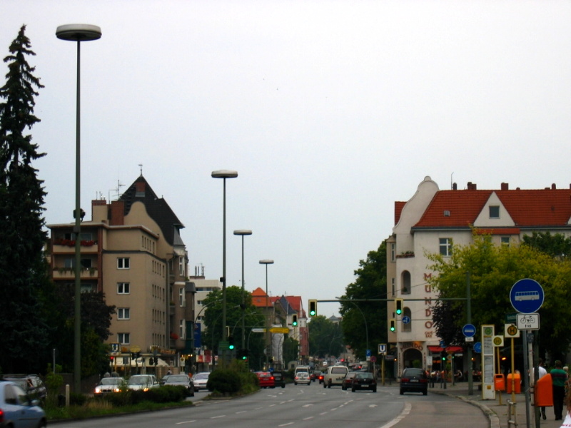
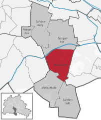
Tempelhof-Schöneberg (Tempelhof-Schöneberg)
.svg)
- borough of Berlin, Germany
 Hiking in Tempelhof-Schöneberg
Tempelhof-Schöneberg is a unique district in Berlin, known more for its urban environment than traditional hiking trails. However, it does offer opportunities for outdoor activities and scenic walks. Here are some highlights for exploring the area on foot:
-
Tempelhofer Feld: The former Tempelhof Airport has been transformed into a massive public park. You can walk, run, bike, or simply enjoy picnicking on its expansive open grassy areas. The unique landscape and remnants of the airport give it a distinctly urban hiking experience.
-
Parks and Green Spaces: There are several smaller parks in the area, such as Schöneberger Südgelände which features a nature reserve with walking trails that wind through an abandoned railway yard and lush vegetation. This park offers a blend of industrial history and nature, with opportunities to spot various plant and animal species.
-
Landscape Walks: The district is also close to the Teltow Canal, which offers a scenic route for walking alongside water. The path along the canal provides beautiful views and a peaceful atmosphere away from the hustle and bustle of the city.
-
Local Churches and Historical Sites: Exploring the district on foot allows you to discover its rich history, such as the iconic Schöneberg Church and the historic buildings in the area.
-
Neighborhoods: Each neighborhood in Tempelhof-Schöneberg has its own character. You can spend time walking through the streets of Schöneberg to appreciate the mix of urban architecture, cafes, and local shops.
For a more immersive hiking experience, nearby regions like the Grunewald Forest or the Berlin Wall Trail could be considered for longer hikes. Remember to wear comfortable shoes, stay hydrated, and check the weather forecast before heading out!
- Country:

- Coordinates: 52° 28' 0" N, 13° 23' 0" E


- GPS tracks (wikiloc): [Link]
- Area: 531 sq km
- Web site: http://www.berlin.de/ba-tempelhof-schoeneberg
- Wikipedia en: wiki(en)
- Wikipedia: wiki(de)
- Wikidata storage: Wikidata: Q158106
- Wikipedia Commons Gallery: [Link]
- Wikipedia Commons Category: [Link]
- Freebase ID: [/m/022nc1]
- GeoNames ID: Alt: [3336297]
- VIAF ID: Alt: [239231665]
- OSM relation ID: [158437]
- GND ID: Alt: [7571571-5]
- archINFORM location ID: [43208]
- TGN ID: [7032549]
- Encyclopædia Britannica Online ID: [place/Tempelhof]
Includes regions:


Berlin-Schöneberg
- locality of Berlin, Germany
Hiking in Berlin-Schöneberg
Hiking in Schöneberg, a district in Berlin, Germany, offers a unique blend of urban exploration and access to green spaces. While Schöneberg is primarily known for its vibrant city life, you can find several parks and natural areas that provide great opportunities for hiking and outdoor activities....
- Country:
- Postal Code: 12169; 12161; 12159; 12157; 10829; 10827; 10825; 10823; 10789; 10787; 10783; 10781; 10779; 10777
- Coordinates: 52° 28' 59" N, 13° 20' 59" E
- GPS tracks (wikiloc): [Link]
- AboveSeaLevel: 47 м m
- Area: 10.61 sq km
- Population: 118368


Tempelhof
- locality of Berlin
Hiking in Tempelhof
Tempelhof, a district in Berlin, Germany, is known more for its urban atmosphere than for traditional hiking trails. However, it has unique outdoor spaces that can offer enjoyable walking and exploring experiences for those looking for a more urban hike....
- Country:
- Postal Code: 12279; 12099; 12109; 12105; 12103; 12101
- Coordinates: 52° 28' 0" N, 13° 23' 0" E
- GPS tracks (wikiloc): [Link]
- AboveSeaLevel: 47 м m
- Area: 12.2 sq km
- Population: 59728
Mariendorf
- locality of Berlin, Germany
Hiking in Mariendorf
Mariendorf is a district in the borough of Tempelhof-Schöneberg in Berlin, Germany. While it may not be known for traditional hiking trails like you might find in more mountainous regions, there are still opportunities for outdoor activities and walks in and around the area....
- Country:
- Postal Code: 12109; 12107; 12105
- Coordinates: 52° 26' 24" N, 13° 23' 24" E
- GPS tracks (wikiloc): [Link]
- AboveSeaLevel: 49 м m
- Area: 9.38 sq km
- Population: 50956


Friedenau
- locality of Berlin, Germany
Hiking in Friedenau
Friedenau is a neighborhood in Berlin, Germany, known primarily for its residential areas, parks, and historical architecture rather than for traditional hiking trails. However, if you're interested in nearby walking or hiking opportunities, here are some options you can explore:...
- Country:
- Postal Code: 14197; 12161; 12159; 12157; 10827
- Coordinates: 52° 28' 20" N, 13° 19' 40" E
- GPS tracks (wikiloc): [Link]
- AboveSeaLevel: 44 м m
- Area: 1.65 sq km
- Population: 27499


Marienfelde
- locality of Berlin, Germany
Hiking in Marienfelde
Marienfelde is a district located in the southwestern part of Berlin, Germany. While it may not be a traditional hiking destination with extensive trails like you might find in national parks, there are still some opportunities for walking and exploring the natural surroundings in and around the area....
- Country:
- Postal Code: 12249; 12279; 12277
- Coordinates: 52° 25' 0" N, 13° 22' 0" E
- GPS tracks (wikiloc): [Link]
- AboveSeaLevel: 44 м m
- Area: 9.15 sq km
- Population: 31372


Lichtenrade
- locality of Berlin, Germany
Hiking in Lichtenrade
Lichtenrade, a district of Berlin, is more urban than it is rural, but you can still enjoy some outdoor activities in and around the area. If you're looking for hiking opportunities, here are a few suggestions:...
- Country:
- Postal Code: 12309; 12307; 12305
- Coordinates: 52° 24' 0" N, 13° 24' 0" E
- GPS tracks (wikiloc): [Link]
- AboveSeaLevel: 45 м m
- Area: 10.1 sq km
- Population: 49843
Shares border with regions:

Steglitz-Zehlendorf
- borough of Berlin, Germany
Hiking in Steglitz-Zehlendorf
Steglitz-Zehlendorf, a district in southwest Berlin, offers a lovely blend of urban and natural landscapes, making it a unique hiking destination. Here are some key points to consider when hiking in this area:...
- Country:
- Coordinates: 52° 26' 0" N, 13° 15' 0" E
- GPS tracks (wikiloc): [Link]
- Area: 103 sq km
- Web site: [Link]

Charlottenburg-Wilmersdorf
- borough of Berlin, Germany
Hiking in Charlottenburg-Wilmersdorf
Charlottenburg-Wilmersdorf is a district in Berlin that, while primarily urban, offers some enjoyable opportunities for hiking and outdoor activities. Here are a few highlights and tips for hiking in and around the area:...
- Country:
- Coordinates: 52° 30' 0" N, 13° 17' 0" E
- GPS tracks (wikiloc): [Link]
- Area: 64.7 sq km
- Population: 334351
- Web site: [Link]


Friedrichshain-Kreuzberg
- borough of Berlin, Germany
Hiking in Friedrichshain-Kreuzberg
Friedrichshain-Kreuzberg is a vibrant district in Berlin, known for its rich culture, street art, and diverse communities rather than traditional hiking trails. However, it does offer some great opportunities for walking and exploring. Here are some options for those looking to enjoy urban hiking in this area:...
- Country:
- Coordinates: 52° 30' 0" N, 13° 27' 0" E
- GPS tracks (wikiloc): [Link]
- Area: 20.2 sq km
- Population: 281076
- Web site: [Link]


Mitte
- borough of Berlin, Germany
Hiking in Mitte
Mitte is a central borough of Berlin, Germany, and while it's better known for its urban environment, historical landmarks, and museums, there are some nearby outdoor opportunities for hiking and nature exploration. Here are a few options for enjoying a hike around Mitte and the surrounding areas:...
- Country:
- Coordinates: 52° 31' 0" N, 13° 22' 0" E
- GPS tracks (wikiloc): [Link]
- Area: 39.5 sq km
- Population: 333905
- Web site: [Link]

Neukölln
- borough of Berlin, Germany
Hiking in Neukölln
Neukölln is one of the most vibrant districts in Berlin, Germany, known for its diverse culture, artistic scenes, and community spaces. While it's not traditionally associated with hiking in the classic sense, there are still some great outdoor activities and parks in the area that can provide a satisfying experience for those looking to enjoy nature and explore on foot....
- Country:
- Coordinates: 52° 29' 0" N, 13° 27' 0" E
- GPS tracks (wikiloc): [Link]
- Area: 44.9 sq km
- Population: 306000
- Web site: [Link]