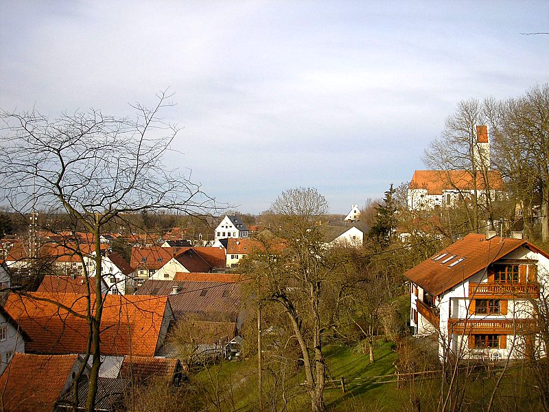
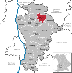
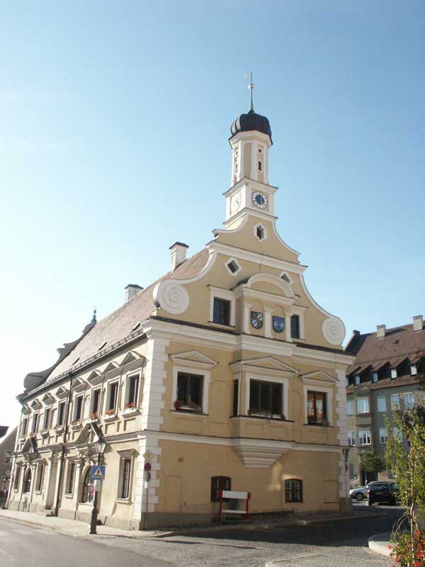
Aichach-Friedberg (Landkreis Aichach-Friedberg)

- district in Bavaria, Germany
 Hiking in Aichach-Friedberg
Aichach-Friedberg is a beautiful region located in Bavaria, Germany, known for its diverse landscapes, charming villages, and historical sites. Hiking in this area offers a variety of trails that cater to different skill levels, making it an excellent destination for both novice hikers and experienced outdoor enthusiasts.
Hiking Trails
-
Aichach Circle Trail: This is a popular circular trail that takes you around the town of Aichach. It offers views of the countryside, pastures, and historical landmarks. The route is relatively easy, making it suitable for families.
-
Friedberg Historical Trails: Friedberg features several trails that connect to significant historical sites, including castles and old churches. The towns themselves are full of heritage, providing a rich cultural backdrop to your hike.
-
Nature Trails: The region is home to various nature reserves and parks, such as the Lech River Valley, which offers scenic views and diverse flora and fauna. Trails in these areas may vary in difficulty but often present opportunities for birdwatching and enjoying the local wildlife.
-
The Swabian Jura: A bit further afield, the Swabian Jura offers more challenging hikes with stunning vistas and geological features. You can find well-marked trails that lead to picturesque viewpoints, caves, and rock formations.
Things to Consider
-
Trail Markings: Most hiking trails in the area are well-marked, but it’s advisable to carry a map or a GPS device for navigation.
-
Weather: The weather can change quickly in Bavaria, so check the forecast before heading out and dress accordingly. Layers are a good option, along with waterproof gear.
-
Local Amenities: In many small towns in the Aichach-Friedberg region, you'll find local restaurants, cafes, and shops where you can stop for refreshments or a meal after your hike.
-
Guided Tours: If you're new to hiking or unfamiliar with the area, consider joining a guided hiking group. Local guides can provide insights into the history and ecology of the region.
Conclusion
Hiking in Aichach-Friedberg offers a mix of natural beauty and cultural exploration. Whether you're looking to enjoy a leisurely walk through charming villages or take on more rigorous trails in nature, this Bavarian region has something for everyone. Always make sure to check local regulations and trail conditions before heading out. Enjoy your hike!
- Country:

- Capital: Aichach
- Licence Plate Code: FDB; AIC
- Coordinates: 48° 25' 12" N, 11° 4' 48" E


- GPS tracks (wikiloc): [Link]
- AboveSeaLevel: 483 м m
- Area: 781.00 sq km
- Population: 101792
- Web site: http://www.lra-aic-fdb.de/
- Wikipedia en: wiki(en)
- Wikipedia: wiki(de)
- Wikidata storage: Wikidata: Q10415
- Wikipedia Commons Category: [Link]
- Wikipedia Commons Maps Category: [Link]
- Freebase ID: [/m/019wsn]
- GeoNames ID: Alt: [2803463]
- BnF ID: [11995527b]
- VIAF ID: Alt: [123954112]
- OSM relation ID: [62377]
- GND ID: Alt: [4000831-9]
- archINFORM location ID: [9431]
- Library of Congress authority ID: Alt: [n81035212]
- TGN ID: [7077539]
- Bavarikon ID: [ODB_A00000550]
- ISNI: Alt: [0000 0004 0480 2967]
- NUTS code: [DE275]
- Ringgold ID: [219620]
- BabelNet ID: [01153843n]
- German district key: 09771
Includes regions:


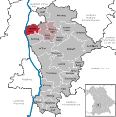
Kühbach
- place in Bavaria, Germany
Hiking in Kühbach
Kühbach, located in Bavaria, Germany, is a beautiful area for hiking with picturesque landscapes and a variety of trails suitable for different skill levels. The region is known for its tranquil environment, charming rural scenery, and well-marked hiking paths that cater to both casual walkers and more seasoned hikers....
- Country:
- Postal Code: 86556
- Local Dialing Code: 08251
- Licence Plate Code: AIC
- Coordinates: 48° 29' 30" N, 11° 11' 12" E
- GPS tracks (wikiloc): [Link]
- AboveSeaLevel: 457 м m
- Area: 37.57 sq km
- Population: 3165
- Web site: [Link]

Merching
- place in Bavaria, Germany
Hiking in Merching
Merching, a small town located in Bavaria, Germany, offers a charming backdrop for hiking enthusiasts. While it might not be as widely known as some larger hiking destinations, it presents several opportunities to explore scenic landscapes, local nature, and cultural landmarks....
- Country:
- Postal Code: 86504
- Local Dialing Code: 08233
- Licence Plate Code: AIC
- Coordinates: 48° 15' 0" N, 10° 59' 0" E
- GPS tracks (wikiloc): [Link]
- AboveSeaLevel: 529 м m
- Area: 24.83 sq km
- Population: 2233
- Web site: [Link]


Schmiechen
- municipality of Germany
Hiking in Schmiechen
Schmiechen is a small village located in Bavaria, Germany, known for its picturesque landscapes and tranquil surroundings. While it may not be a widely recognized hiking destination, there are several opportunities for outdoor enthusiasts to explore the natural beauty of the area....
- Country:
- Postal Code: 86511
- Local Dialing Code: 08206
- Licence Plate Code: AIC
- Coordinates: 48° 13' 0" N, 10° 58' 0" E
- GPS tracks (wikiloc): [Link]
- AboveSeaLevel: 542 м m
- Area: 13.50 sq km
- Population: 950
- Web site: [Link]


Sielenbach
- municipality of Germany
Hiking in Sielenbach
Sielenbach, located in Bavaria, Germany, is a charming town that offers a variety of hiking opportunities amidst beautiful natural landscapes. Here are some hiking highlights and tips for exploring the area:...
- Country:
- Postal Code: 86577
- Local Dialing Code: 08258
- Licence Plate Code: AIC
- Coordinates: 48° 24' 0" N, 11° 10' 0" E
- GPS tracks (wikiloc): [Link]
- AboveSeaLevel: 467 м m
- Area: 17.87 sq km
- Population: 1222
- Web site: [Link]

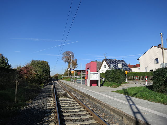
Aichach
- municipality of Germany
Hiking in Aichach
Aichach, located in Bavaria, Germany, is a wonderful area for hiking enthusiasts. The region is characterized by beautiful landscapes, rolling hills, and a mix of forested areas and farmland, making it an ideal destination for both casual hikers and more experienced trekkers....
- Country:
- Postal Code: 86551
- Local Dialing Code: 08251
- Coordinates: 48° 27' 0" N, 11° 8' 0" E
- GPS tracks (wikiloc): [Link]
- AboveSeaLevel: 448 м m
- Area: 92.97 sq km
- Population: 22033
- Web site: [Link]


Pöttmes
- municipality of Germany
Hiking in Pöttmes
Pöttmes is a charming village in Bavaria, Germany, located near the foothills of the Alps. While it may not be as famous as larger hiking destinations, Pöttmes and its surrounding area offer some delightful hiking opportunities. Here are some highlights:...
- Country:
- Postal Code: 86554
- Local Dialing Code: 08253
- Licence Plate Code: AIC
- Coordinates: 48° 35' 0" N, 11° 6' 0" E
- GPS tracks (wikiloc): [Link]
- AboveSeaLevel: 410 м m
- Area: 82.58 sq km
- Population: 5580
- Web site: [Link]


Petersdorf
- municipality of Germany
Hiking in Petersdorf
Petersdorf is a charming village located in Bavaria, Germany, surrounded by the picturesque landscape of the Bavarian countryside. While it may not be as well-known as some of the major hiking destinations in the region, it offers a range of beautiful trails suitable for various skill levels....
- Country:
- Postal Code: 86574
- Local Dialing Code: 08237
- Licence Plate Code: AIC
- Coordinates: 48° 30' 0" N, 11° 1' 0" E
- GPS tracks (wikiloc): [Link]
- AboveSeaLevel: 461 м m
- Area: 19.49 sq km
- Population: 1645
- Web site: [Link]


Baar
- municipality of Germany
Hiking in Baar
Baar, located in Bavaria, Germany, is a charming area offering a range of hiking opportunities for outdoor enthusiasts. The region is characterized by its picturesque landscapes, rolling hills, dense forests, and scenic meadows, making it a fantastic destination for hikers of all skill levels....
- Country:
- Postal Code: 86674
- Local Dialing Code: 08276
- Licence Plate Code: AIC
- Coordinates: 48° 34' 0" N, 10° 58' 0" E
- GPS tracks (wikiloc): [Link]
- AboveSeaLevel: 438 м m
- Area: 16.94 sq km
- Population: 1134
- Web site: [Link]

Kissing
- municipality of Germany
Hiking in Kissing
Kissing, located in Bavaria, Germany, offers a variety of hiking opportunities that allow you to explore the beautiful Bavarian countryside. Situated near the foothills of the Alps, Kissing provides access to numerous trails that cater to different skill levels, ranging from easy walks to more challenging hikes....
- Country:
- Postal Code: 86438
- Local Dialing Code: 08233
- Licence Plate Code: AIC
- Coordinates: 48° 18' 0" N, 10° 59' 0" E
- GPS tracks (wikiloc): [Link]
- AboveSeaLevel: 523 м m
- Area: 23.12 sq km
- Population: 8561
- Web site: [Link]

Adelzhausen
- municipality of Germany
Hiking in Adelzhausen
Adelzhausen, a small village located in Bavaria, Germany, offers a delightful experience for hiking enthusiasts. Nestled in the picturesque landscape of southern Germany, it's surrounded by rolling hills, lush forests, and scenic farmland, making it an ideal destination for those looking to enjoy nature....
- Country:
- Postal Code: 86559
- Local Dialing Code: 08258
- Licence Plate Code: AIC
- Coordinates: 48° 21' 0" N, 11° 8' 0" E
- GPS tracks (wikiloc): [Link]
- AboveSeaLevel: 486 м m
- Area: 16.97 sq km
- Population: 1084
- Web site: [Link]


Aindling
- municipality of Germany
Hiking in Aindling
Aindling, a small town in Bavaria, Germany, is surrounded by beautiful natural landscapes that offer various opportunities for hiking enthusiasts. The area is characterized by rolling hills, picturesque fields, and serene woodlands, making it ideal for both casual walkers and more seasoned hikers....
- Country:
- Postal Code: 86447
- Local Dialing Code: 08237
- Licence Plate Code: AIC
- Coordinates: 48° 31' 0" N, 10° 57' 0" E
- GPS tracks (wikiloc): [Link]
- AboveSeaLevel: 458 м m
- Area: 31.43 sq km
- Population: 3471
- Web site: [Link]

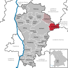
Inchenhofen
- municipality of Germany
Hiking in Inchenhofen
Inchenhofen is a charming municipality located in Bavaria, Germany, known for its picturesque landscapes and tranquil countryside. While it may not be as widely recognized as some of Germany's larger hiking destinations, it offers numerous opportunities for hiking enthusiasts....
- Country:
- Postal Code: 86570
- Local Dialing Code: 08257
- Licence Plate Code: AIC
- Coordinates: 48° 31' 0" N, 11° 7' 0" E
- GPS tracks (wikiloc): [Link]
- AboveSeaLevel: 467 м m
- Area: 27.55 sq km
- Population: 1937
- Web site: [Link]


Affing
- municipality of Germany
Hiking in Affing
Affing, a municipality located in Bavaria, Germany, offers scenic hiking opportunities that cater to a variety of skill levels. The area is rich in natural beauty, characterized by lush forests, rolling hills, and picturesque farmland....
- Country:
- Postal Code: 86444
- Local Dialing Code: 08207
- Coordinates: 48° 28' 0" N, 10° 59' 0" E
- GPS tracks (wikiloc): [Link]
- AboveSeaLevel: 476 м m
- Area: 44.86 sq km
- Population: 4140
- Web site: [Link]

Todtenweis
- municipality of Germany
Hiking in Todtenweis
Todtenweis, located in Bavaria, Germany, is a beautiful region that offers a variety of hiking opportunities. The area is characterized by its scenic landscapes, including forests, rolling hills, and traditional Bavarian countryside. Here are some key points to consider if you're planning a hiking trip in Todtenweis:...
- Country:
- Postal Code: 86447
- Local Dialing Code: 08237
- Licence Plate Code: AIC
- Coordinates: 48° 31' 0" N, 10° 56' 0" E
- GPS tracks (wikiloc): [Link]
- AboveSeaLevel: 450 м m
- Area: 20.28 sq km
- Population: 1187
- Web site: [Link]

Rehling
- municipality of Germany
Hiking in Rehling
Rehling is a small town located in Bavaria, Germany, known for its picturesque landscapes and access to various hiking trails. While it may not be as widely recognized as some of the larger hiking destinations in Germany, it offers several charming local trails that showcase the natural beauty of the region....
- Country:
- Postal Code: 86508
- Local Dialing Code: 08237
- Licence Plate Code: AIC
- Coordinates: 48° 29' 0" N, 10° 56' 0" E
- GPS tracks (wikiloc): [Link]
- AboveSeaLevel: 497 м m
- Area: 26.26 sq km
- Population: 1956
- Web site: [Link]
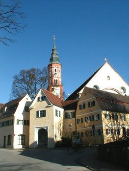
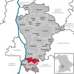
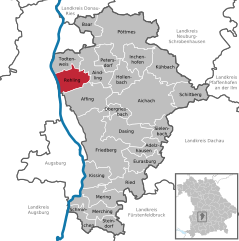
Mering
- municipality of Germany
Hiking in Mering
Mering, located in Bavaria, Germany, offers a variety of hiking opportunities that cater to different skill levels and preferences. The surrounding scenic landscapes include rolling hills, woodlands, and agricultural fields, providing a charming backdrop for outdoor enthusiasts....
- Country:
- Postal Code: 86415
- Local Dialing Code: 08233
- Licence Plate Code: AIC
- Coordinates: 48° 15' 45" N, 10° 59' 4" E
- GPS tracks (wikiloc): [Link]
- AboveSeaLevel: 521 м m
- Area: 26.87 sq km
- Population: 14175
- Web site: [Link]

Schiltberg
- municipality in Bavaria in Germany
Hiking in Schiltberg
Schiltberg, located in Germany, offers beautiful hiking opportunities with a mix of scenic views and natural landscapes. The area is characterized by its rolling hills, forests, and charming countryside. Here are some key points to consider if you're planning a hiking trip in Schiltberg:...
- Country:
- Postal Code: 86576
- Local Dialing Code: 08259
- Licence Plate Code: AIC
- Coordinates: 48° 28' 0" N, 11° 14' 0" E
- GPS tracks (wikiloc): [Link]
- AboveSeaLevel: 455 м m
- Area: 29.78 sq km
- Population: 1637
- Web site: [Link]


Steindorf
- municipality of Germany
Hiking in Steindorf
Steindorf is a charming village located in Austria, nestled near the beautiful Lake Ossiach and surrounded by the dramatic backdrop of the Carinthian Alps. Hiking in this region offers stunning landscapes, diverse flora and fauna, and a variety of trails suitable for different skill levels. Here are some highlights of hiking in and around Steindorf:...
- Country:
- Postal Code: 82297
- Local Dialing Code: 08202
- Licence Plate Code: AIC
- Coordinates: 48° 13' 0" N, 11° 0' 0" E
- GPS tracks (wikiloc): [Link]
- AboveSeaLevel: 539 м m
- Area: 16.19 sq km
- Population: 805
- Web site: [Link]
Obergriesbach
- municipality of Germany
Hiking in Obergriesbach
Obergriesbach is a charming area in Bavaria, Germany, known for its picturesque landscapes and outdoor activities, including hiking. The region offers a variety of trails suitable for different skill levels, from leisurely walks to more challenging hikes....
- Country:
- Postal Code: 86573
- Local Dialing Code: 08251; 08205
- Licence Plate Code: AIC
- Coordinates: 48° 25' 0" N, 11° 4' 0" E
- GPS tracks (wikiloc): [Link]
- AboveSeaLevel: 479 м m
- Area: 10.31 sq km
- Population: 1545
- Web site: [Link]
Hollenbach
- municipality of Germany
Hiking in Hollenbach
Hollenbach is a beautiful area for hiking, known for its scenic landscapes and tranquil surroundings. While specific trails can vary in difficulty and distance, here are some general pointers and highlights you might find when hiking in and around Hollenbach:...
- Country:
- Postal Code: 86568
- Local Dialing Code: 08257
- Licence Plate Code: AIC
- Coordinates: 48° 29' 0" N, 11° 4' 0" E
- GPS tracks (wikiloc): [Link]
- AboveSeaLevel: 456 м m
- Area: 26.12 sq km
- Population: 1996
- Web site: [Link]

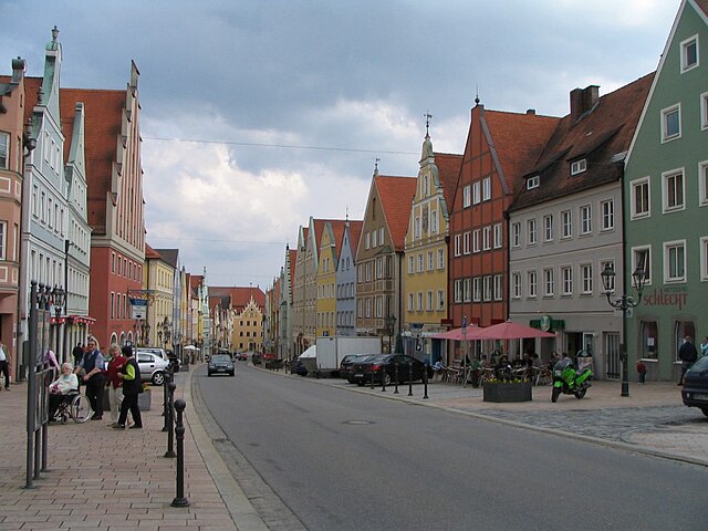
Friedberg
- municipality of Germany
Hiking in Friedberg
Friedberg, located in Bavaria, Germany, is a charming town that serves as a gateway to some beautiful hiking trails in the surrounding region. The area is characterized by a mix of picturesque landscapes, historical sites, and well-marked trails....
- Country:
- Postal Code: 86316
- Local Dialing Code: 0821
- Coordinates: 48° 21' 0" N, 10° 59' 0" E
- GPS tracks (wikiloc): [Link]
- AboveSeaLevel: 516 м m
- Area: 81.20 sq km
- Population: 25580
- Web site: [Link]


Ried
- municipality of Germany
Hiking in Ried
Ried, located in Bavaria, Germany, is an area surrounded by natural beauty, making it a lovely destination for hiking enthusiasts. The Bavarian countryside offers a mix of rolling hills, lush forests, and picturesque landscapes. Here are some highlights and tips for hiking in and around Ried:...
- Country:
- Postal Code: 86510
- Local Dialing Code: 08233; 08208; 08202
- Licence Plate Code: AIC
- Coordinates: 48° 18' 0" N, 11° 3' 0" E
- GPS tracks (wikiloc): [Link]
- AboveSeaLevel: 526 м m
- Area: 29.21 sq km
- Population: 2357
- Web site: [Link]
Eurasburg
- municipality of Germany
Hiking in Eurasburg
Eurasburg, located in the Swabia region of Bavaria, Germany, offers a picturesque setting for hiking enthusiasts. The area is characterized by its rolling hills, lush forests, and charming rural landscapes, making it an ideal destination for both casual walkers and seasoned hikers....
- Country:
- Postal Code: 86495
- Local Dialing Code: 08208
- Licence Plate Code: AIC
- Coordinates: 48° 20' 0" N, 11° 5' 0" E
- GPS tracks (wikiloc): [Link]
- AboveSeaLevel: 501 м m
- Area: 23.94 sq km
- Population: 1214
- Web site: [Link]
Dasing
- municipality of Germany
Hiking in Dasing
Hiking in Dasing, a small municipality in Bavaria, Germany, offers a blend of natural beauty and cultural experiences. The region is characterized by scenic countryside, charming villages, and well-maintained trails. Here are some key points to consider for hiking in Dasing:...
- Country:
- Postal Code: 86453
- Local Dialing Code: 08205
- Licence Plate Code: AIC
- Coordinates: 48° 22' 0" N, 11° 3' 0" E
- GPS tracks (wikiloc): [Link]
- AboveSeaLevel: 470 м m
- Area: 40.91 sq km
- Population: 4173
- Web site: [Link]
Shares border with regions:
Augsburg
- district in Bavaria, Germany
Hiking in Augsburg
Augsburg is a city in Bavaria, Germany, known for its rich history and beautiful surroundings, making it a great base for hiking enthusiasts. While the city itself offers various parks and local trails, the surrounding district provides a variety of hiking options for different skill levels. Here are some highlights:...
- Country:
- Capital: Augsburg
- Licence Plate Code: A
- Coordinates: 48° 25' 12" N, 10° 49' 48" E
- GPS tracks (wikiloc): [Link]
- AboveSeaLevel: 521 м m
- Area: 1071.00 sq km
- Population: 191469
- Web site: [Link]
Donau-Ries
- district in Bavaria, Germany
Hiking in Donau-Ries
Donau-Ries is a beautiful region in Bavaria, Germany, known for its stunning landscapes, rich history, and cultural significance. Spanning both the Danube River and the Ries crater, this area offers diverse hiking opportunities for both beginners and more experienced trekkers....
- Country:
- Capital: Donauwörth
- Licence Plate Code: NÖ; DON
- Coordinates: 48° 49' 48" N, 10° 40' 12" E
- GPS tracks (wikiloc): [Link]
- AboveSeaLevel: 508 м m
- Area: 1275.00 sq km
- Population: 117483
- Web site: [Link]


Neuburg-Schrobenhausen
- district of Bavaria, Germany
Hiking in Neuburg-Schrobenhausen
Neuburg-Schrobenhausen is a picturesque district in Bavaria, Germany, offering a mix of beautiful landscapes, rich history, and outdoor activities. When it comes to hiking in this area, there are several trails and natural attractions to explore. Here’s what you should know:...
- Country:
- Capital: Neuburg an der Donau
- Licence Plate Code: SOB; ND
- Coordinates: 48° 40' 12" N, 11° 10' 12" E
- GPS tracks (wikiloc): [Link]
- AboveSeaLevel: 378 м m
- Area: 740.00 sq km
- Population: 76493
- Web site: [Link]

Pfaffenhofen
- district of Bavaria, Germany
Hiking in Pfaffenhofen
Pfaffenhofen is a district in Bavaria, Germany, known for its picturesque landscapes and outdoor recreational opportunities, including hiking. The region features a mix of rolling hills, forests, rivers, and farmland, providing a variety of scenic routes for hikers of all skill levels....
- Country:
- Capital: Pfaffenhofen an der Ilm
- Licence Plate Code: PAF
- Coordinates: 48° 30' 0" N, 11° 30' 0" E
- GPS tracks (wikiloc): [Link]
- AboveSeaLevel: 439 м m
- Area: 760.00 sq km
- Population: 126244
- Web site: [Link]

Dachau
- district of Bavaria, Germany
Hiking in Dachau
Dachau, located just north of Munich in Bavaria, Germany, is a region rich in history and natural beauty, making it a great destination for hiking. Here are some highlights about hiking in the Dachau district:...
- Country:
- Capital: Dachau
- Licence Plate Code: DAH
- Coordinates: 48° 15' 0" N, 11° 25' 12" E
- GPS tracks (wikiloc): [Link]
- AboveSeaLevel: 506 м m
- Area: 579.00 sq km
- Population: 152703
- Web site: [Link]


Fürstenfeldbruck
- district of Bavaria, Germany
Hiking in Fürstenfeldbruck
Fürstenfeldbruck is a beautiful district located just outside of Munich, Germany, and offers a variety of scenic hiking opportunities. The region is characterized by its rolling hills, lush forests, and picturesque landscapes, making it a great destination for hikers of all skill levels....
- Country:
- Capital: Fürstenfeldbruck
- Licence Plate Code: FFB
- Coordinates: 48° 10' 12" N, 11° 10' 12" E
- GPS tracks (wikiloc): [Link]
- AboveSeaLevel: 550 м m
- Area: 435.00 sq km
- Population: 172760
- Web site: [Link]

Landsberg
- district of Bavaria, Germany
Hiking in Landsberg
Landsberg district, located in Bavaria, Germany, is a beautiful area that offers a variety of hiking opportunities amidst stunning natural landscapes. The region is characterized by its rolling hills, lush forests, and picturesque lakes, making it an ideal destination for outdoor enthusiasts. Here are some key points about hiking in Landsberg district:...
- Country:
- Capital: Landsberg am Lech
- Licence Plate Code: LL
- Coordinates: 48° 1' 12" N, 10° 57' 0" E
- GPS tracks (wikiloc): [Link]
- AboveSeaLevel: 636 м m
- Area: 804.00 sq km
- Population: 83612
- Web site: [Link]
Augsburg
- city in Bavaria, Germany
Hiking in Augsburg
Augsburg, located in Bavaria, Germany, is a charming city that offers various outdoor activities, including hiking. While the city itself is urban, it provides easy access to beautiful natural landscapes in the surrounding areas, making it a great base for hiking enthusiasts....
- Country:
- Postal Code: 86179; 86169; 86167; 86165; 86163; 86161; 86159; 86157; 86156; 86154; 86153; 86152; 86199; 86150
- Local Dialing Code: 0821
- Licence Plate Code: A
- Coordinates: 48° 22' 18" N, 10° 53' 54" E
- GPS tracks (wikiloc): [Link]
- AboveSeaLevel: 482 м m
- Area: 146.87 sq km
- Population: 289584
- Web site: [Link]