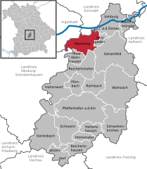
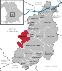
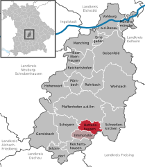
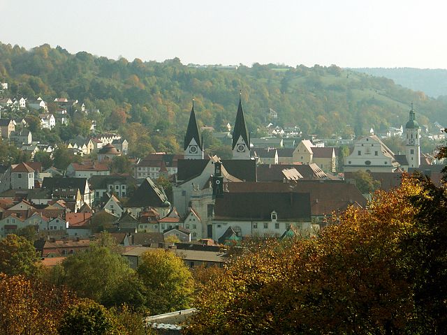
Pfaffenhofen (Landkreis Pfaffenhofen a. d. Ilm)

- district of Bavaria, Germany
 Hiking in Pfaffenhofen
Pfaffenhofen is a district in Bavaria, Germany, known for its picturesque landscapes and outdoor recreational opportunities, including hiking. The region features a mix of rolling hills, forests, rivers, and farmland, providing a variety of scenic routes for hikers of all skill levels.
Hiking Opportunities in Pfaffenhofen District
-
Trails and Routes: There are numerous marked hiking trails throughout the district that range in difficulty. Some popular options include:
- Local Nature Trails: These often highlight the natural beauty of the surrounding countryside, including forests and fields.
- Long-distance Trails: For those seeking a challenge, longer routes may connect to neighboring regions and can take several hours to complete.
-
Landscapes: Hikers in Pfaffenhofen can enjoy diverse landscapes, including the scenic banks of the River Ilm, lush meadows, and charming villages. The trails often feature viewpoints overlooking the countryside and the Alps in the distance on clear days.
-
Accessibility: Many trails are well-marked and accessible for families and beginners. There are also options for more experienced hikers looking for off-the-beaten-path experiences.
-
Flora and Fauna: The region is home to a variety of wildlife, and hikers might spot birds, deer, and other animals along the trails. The area also features a diverse range of plant life, contributing to its natural beauty.
-
Additional Activities: Besides hiking, the Pfaffenhofen district also offers opportunities for cycling, picnicking, and enjoying nature. You may find local amenities, like cafés in nearby towns where you can replenish after a hike.
-
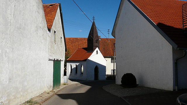
Cultural Sites: Some trails may also lead you to historical or cultural sites, such as small chapels or village markets, integrating the natural experience with the region’s rich history.
Tips for Hiking in Pfaffenhofen
- Preparation: Ensure you have suitable hiking gear, including sturdy shoes, appropriate clothing for the weather, and a backpack with water and snacks.
- Navigation: While many trails are marked, bringing a map or using a hiking app can be helpful, especially for longer hikes.
- Local Guidelines: Be mindful of local regulations and respect nature; follow the Leave No Trace principles to preserve the beauty of the area.
- Weather: Check the weather forecast before heading out, as conditions can change swiftly, particularly in the spring and fall.
In summary, Pfaffenhofen district is a lovely area for hiking enthusiasts, offering a blend of natural beauty, well-marked trails, and the chance to explore Bavarian culture. Whether you're a novice or a seasoned hiker, you'll find something to enjoy in this region.
- Country:

- Capital: Pfaffenhofen an der Ilm
- Licence Plate Code: PAF
- Coordinates: 48° 30' 0" N, 11° 30' 0" E


- GPS tracks (wikiloc): [Link]
- AboveSeaLevel: 439 м m
- Area: 760.00 sq km
- Population: 126244
- Web site: http://www.landkreis-pfaffenhofen.de/
- Wikipedia en: wiki(en)
- Wikipedia: wiki(de)
- Wikidata storage: Wikidata: Q10496
- Wikipedia Commons Category: [Link]
- Freebase ID: [/m/0297s3]
- GeoNames ID: Alt: [2854385]
- VIAF ID: Alt: [236798222]
- OSM relation ID: [62371]
- GND ID: Alt: [4045443-5]
- archINFORM location ID: [5664]
- TGN ID: [7121193]
- Historical Gazetteer (GOV) ID: [adm_139186]
- Bavarikon ID: [ODB_A00002357]
- ISNI: Alt: [0000 0004 0647 2666]
- NUTS code: [DE21J]
- Ringgold ID: [96690]
- German district key: 09186
Includes regions:


Vohburg an der Donau
- town in Bavaria, Germany
Hiking in Vohburg an der Donau
Vohburg, located in Bavaria, Germany, offers a variety of hiking opportunities that can appeal to both casual walkers and more serious hikers. Here are some highlights and tips for hiking in and around Vohburg:...
- Country:
- Postal Code: 85088
- Local Dialing Code: 08457
- Licence Plate Code: PAF
- Coordinates: 48° 46' 11" N, 11° 37' 6" E
- GPS tracks (wikiloc): [Link]
- AboveSeaLevel: 371 м m
- Area: 45.19 sq km
- Population: 5863
- Web site: [Link]

Manching
- municipality of Germany
Hiking in Manching
Hiking in and around Manching, a town located in Bavaria, Germany, offers a delightful experience for outdoor enthusiasts. While Manching itself is not a major hiking destination, its proximity to the Danube River and various scenic landscapes provides opportunities for leisurely walks and more adventurous treks. Here are some highlights to consider when hiking in and around the area:...
- Country:
- Postal Code: 85077; W-8071; W-8072; 8071; 8072
- Local Dialing Code: 08459
- Licence Plate Code: PAF
- Coordinates: 48° 43' 7" N, 11° 29' 50" E
- GPS tracks (wikiloc): [Link]
- AboveSeaLevel: 366 м m
- Area: 35.45 sq km
- Population: 9235
- Web site: [Link]


Ernsgaden
- municipality of Germany
Hiking in Ernsgaden
Ernsgaden is a small district located near the town of Pfaffenhofen an der Ilm in Bavaria, Germany. While it may not be widely known as a hiking destination, the surrounding area offers some beautiful landscapes and trails suitable for hiking enthusiasts....
- Country:
- Postal Code: 85119
- Local Dialing Code: 08452
- Licence Plate Code: PAF
- Coordinates: 48° 44' 0" N, 11° 35' 0" E
- GPS tracks (wikiloc): [Link]
- AboveSeaLevel: 316 м m
- Area: 7.41 sq km
- Population: 1138
- Web site: [Link]

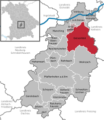
Geisenfeld
- town in Bavaria, Germany
Hiking in Geisenfeld
Geisenfeld, located in Bavaria, Germany, offers a charming environment for hiking enthusiasts. The region is characterized by picturesque landscapes, tranquil countryside, and well-marked trails that cater to various skill levels. Here are some key points to consider for hiking in Geisenfeld:...
- Country:
- Postal Code: 85290
- Local Dialing Code: 08452
- Licence Plate Code: PAF
- Coordinates: 48° 40' 0" N, 11° 36' 0" E
- GPS tracks (wikiloc): [Link]
- AboveSeaLevel: 385 м m
- Area: 88.33 sq km
- Population: 7689
- Web site: [Link]
Gerolsbach
- municipality of Germany
Hiking in Gerolsbach
Gerolsbach, located in Bavaria, Germany, offers a picturesque setting for hiking enthusiasts. The area is characterized by its beautiful landscapes, including rolling hills, forests, and charming rural scenery. Here are some highlights and tips for hiking in Gerolsbach:...
- Country:
- Postal Code: 85302
- Local Dialing Code: 08445
- Licence Plate Code: PAF
- Coordinates: 48° 32' 0" N, 11° 20' 0" E
- GPS tracks (wikiloc): [Link]
- AboveSeaLevel: 459 м m
- Area: 58.98 sq km
- Population: 2439
- Web site: [Link]


Pörnbach
- municipality of Germany
Hiking in Pörnbach
Pörnbach is a small municipality located in Bavaria, Germany, known for its scenic countryside and gentle rolling hills, which can provide a great setting for hiking experiences. While it may not be as famous as some other hiking destinations in Germany, it still offers some lovely trails and nature to explore....
- Country:
- Postal Code: 85309
- Local Dialing Code: 08446
- Licence Plate Code: PAF
- Coordinates: 48° 37' 0" N, 11° 28' 0" E
- GPS tracks (wikiloc): [Link]
- AboveSeaLevel: 396 м m
- Area: 22.63 sq km
- Population: 1485
- Web site: [Link]


Münchsmünster
- municipality of Germany
Hiking in Münchsmünster
Münchsmünster, located in Bavaria, Germany, offers a peaceful escape for hiking enthusiasts looking for serene landscapes and a touch of nature. The area is characterized by its picturesque countryside, rolling hills, and lush forests, making it an excellent destination for both novice and experienced hikers....
- Country:
- Postal Code: 85126
- Local Dialing Code: 08402
- Licence Plate Code: PAF
- Coordinates: 48° 45' 51" N, 11° 41' 28" E
- GPS tracks (wikiloc): [Link]
- AboveSeaLevel: 357 м m
- Area: 16.21 sq km
- Population: 2922
- Web site: [Link]

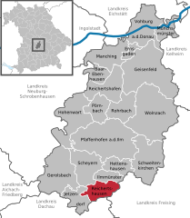
Reichertshausen
- municipality of Germany
Hiking in Reichertshausen
Reichertshausen, located in Bavaria, Germany, is a charming area that offers a variety of hiking opportunities. Nestled in the scenic countryside, it provides a beautiful backdrop for outdoor enthusiasts. Here are a few key points regarding hiking in and around Reichertshausen:...
- Country:
- Postal Code: 85293
- Local Dialing Code: 08441
- Licence Plate Code: PAF
- Coordinates: 48° 28' 0" N, 11° 31' 0" E
- GPS tracks (wikiloc): [Link]
- AboveSeaLevel: 448 м m
- Area: 23.59 sq km
- Population: 3837
- Web site: [Link]
Hohenwart
- municipality of Germany
Hiking in Hohenwart
Hohenwart, located in Bavaria, Germany, offers a variety of hiking opportunities amidst beautiful landscapes and scenic views. The region is characterized by rolling hills, lush forests, and charming villages. Here are some highlights for hiking in Hohenwart:...
- Country:
- Postal Code: 86558
- Local Dialing Code: 08443
- Licence Plate Code: PAF
- Coordinates: 48° 36' 0" N, 11° 23' 0" E
- GPS tracks (wikiloc): [Link]
- AboveSeaLevel: 395 м m
- Area: 52.22 sq km
- Population: 3407
- Web site: [Link]


Ilmmünster
- municipality of Germany
Hiking in Ilmmünster
Ilmmünster is a charming area located in Bavaria, Germany, known for its scenic landscapes and outdoor recreational opportunities. If you're looking to hike in and around Ilmmünster, here are some key points to consider:...
- Country:
- Postal Code: 85304
- Local Dialing Code: 08441
- Licence Plate Code: PAF
- Coordinates: 48° 29' 0" N, 11° 30' 0" E
- GPS tracks (wikiloc): [Link]
- AboveSeaLevel: 470 м m
- Area: 13.89 sq km
- Population: 1590
- Web site: [Link]


Reichertshofen
- municipality of Germany
Hiking in Reichertshofen
Reichertshofen, a town in Bavaria, Germany, is surrounded by beautiful landscapes that make it an excellent destination for hiking enthusiasts. While it may not be as widely known as some of Germany's famous hiking regions, it offers a variety of trails and natural scenery that can cater to different skill levels....
- Country:
- Postal Code: 85084; W-8077; 8077
- Local Dialing Code: 08453
- Licence Plate Code: PAF
- Coordinates: 48° 40' 0" N, 11° 28' 0" E
- GPS tracks (wikiloc): [Link]
- AboveSeaLevel: 381 м m
- Area: 36.90 sq km
- Population: 5624
- Web site: [Link]

Schweitenkirchen
- municipality of Germany
Hiking in Schweitenkirchen
Schweitenkirchen is a small municipality located in Bavaria, Germany, which offers a peaceful environment and beautiful landscapes ideal for hiking enthusiasts. While it may not be as well-known as some of the larger hiking destinations in the Bavarian Alps, it provides opportunities for scenic walks and hikes in the rolling hills and countryside of the region....
- Country:
- Postal Code: 85301
- Local Dialing Code: 08444
- Licence Plate Code: PAF
- Coordinates: 48° 30' 0" N, 11° 37' 0" E
- GPS tracks (wikiloc): [Link]
- AboveSeaLevel: 533 м m
- Area: 53.00 sq km
- Population: 3586
- Web site: [Link]

Rohrbach
- municipality of Germany
Hiking in Rohrbach
Rohrbach, located in Bavaria, Germany, offers a charming landscape for hikers, with scenic trails that cater to various skill levels. Nestled in the picturesque countryside, hikers can expect to encounter lush forests, rolling hills, and quaint villages....
- Country:
- Postal Code: 85296
- Local Dialing Code: 08442
- Licence Plate Code: PAF
- Coordinates: 48° 37' 0" N, 11° 34' 0" E
- GPS tracks (wikiloc): [Link]
- AboveSeaLevel: 426 м m
- Area: 29.63 sq km
- Population: 3461
- Web site: [Link]

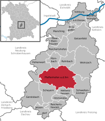
Pfaffenhofen an der Ilm
- town in Bavaria, Germany
Hiking in Pfaffenhofen an der Ilm
Pfaffenhofen an der Ilm is a charming town in Bavaria, Germany, that offers good opportunities for hiking and enjoying the beautiful landscapes of the region. Here are some highlights and tips for hiking around Pfaffenhofen:...
- Country:
- Postal Code: 85276
- Local Dialing Code: 08441
- Coordinates: 48° 32' 0" N, 11° 31' 0" E
- GPS tracks (wikiloc): [Link]
- AboveSeaLevel: 428 м m
- Area: 92.39 sq km
- Population: 17801
- Web site: [Link]

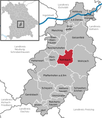
Hettenshausen
- municipality of Germany
Hiking in Hettenshausen
Hettenshausen, located in the state of Bavaria, Germany, offers beautiful landscapes ideal for hiking enthusiasts. The area is characterized by rolling hills, lush forests, and scenic views of the surrounding countryside....
- Country:
- Postal Code: 85276
- Local Dialing Code: 08441
- Licence Plate Code: PAF
- Coordinates: 48° 30' 0" N, 11° 30' 0" E
- GPS tracks (wikiloc): [Link]
- AboveSeaLevel: 435 м m
- Area: 18.6 sq km
- Population: 1532
- Web site: [Link]

Baar-Ebenhausen
- municipality of Germany
Hiking in Baar-Ebenhausen
Baar-Ebenhausen is a small municipality located in Bavaria, Germany. The region is characterized by its natural beauty, making it an appealing destination for hiking enthusiasts. While the area may not be as well-known as some of the larger Bavarian hiking destinations, it offers several attractive trails and natural landscapes for outdoor activities....
- Country:
- Postal Code: 85107
- Local Dialing Code: 08453
- Licence Plate Code: PAF
- Coordinates: 48° 40' 0" N, 11° 26' 0" E
- GPS tracks (wikiloc): [Link]
- AboveSeaLevel: 374 м m
- Area: 14.80 sq km
- Population: 5315
- Web site: [Link]
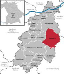
Wolnzach
- municipality of Germany
Hiking in Wolnzach
Wolnzach, located in Bavaria, Germany, offers some beautiful hiking opportunities amidst its picturesque landscape. The region is characterized by its lush greenery, rolling hills, and scenic rural settings. Here are some aspects to consider when hiking in and around Wolnzach:...
- Country:
- Postal Code: 85283
- Local Dialing Code: 08442
- Licence Plate Code: PAF
- Coordinates: 48° 36' 0" N, 11° 37' 0" E
- GPS tracks (wikiloc): [Link]
- AboveSeaLevel: 415 м m
- Area: 91.62 sq km
- Population: 7752
- Web site: [Link]


Jetzendorf
- municipality of Germany
Hiking in Jetzendorf
Jetzendorf is a small municipality in Bavaria, Germany, located near the larger town of Dachau and about 30 kilometers north of Munich. While it may not be as well-known as other hiking destinations, the surrounding area offers some lovely opportunities for hiking and enjoying nature....
- Country:
- Postal Code: 85305
- Local Dialing Code: 08137
- Licence Plate Code: PAF
- Coordinates: 48° 25' 0" N, 11° 25' 0" E
- GPS tracks (wikiloc): [Link]
- AboveSeaLevel: 481 м m
- Area: 21.72 sq km
- Population: 2225
- Web site: [Link]


Scheyern
- municipality of Germany
Hiking in Scheyern
Scheyern is a small village located in Bavaria, Germany, not far from the town of Pfaffenhofen an der Ilm. While it might not be as well-known as some larger hiking destinations, it offers pleasant trails and beautiful scenery typical of the Bavarian countryside....
- Country:
- Postal Code: 85298
- Local Dialing Code: 08441
- Licence Plate Code: PAF
- Coordinates: 48° 30' 0" N, 11° 28' 0" E
- GPS tracks (wikiloc): [Link]
- AboveSeaLevel: 479 м m
- Area: 38.29 sq km
- Population: 3468
- Web site: [Link]
Shares border with regions:
Aichach-Friedberg
- district in Bavaria, Germany
Hiking in Aichach-Friedberg
Aichach-Friedberg is a beautiful region located in Bavaria, Germany, known for its diverse landscapes, charming villages, and historical sites. Hiking in this area offers a variety of trails that cater to different skill levels, making it an excellent destination for both novice hikers and experienced outdoor enthusiasts....
- Country:
- Capital: Aichach
- Licence Plate Code: FDB; AIC
- Coordinates: 48° 25' 12" N, 11° 4' 48" E
- GPS tracks (wikiloc): [Link]
- AboveSeaLevel: 483 м m
- Area: 781.00 sq km
- Population: 101792
- Web site: [Link]

Kelheim
- district in Bavaria, Germany
Hiking in Kelheim
Kelheim, located in Bavaria, Germany, is a beautiful area for hiking, characterized by its stunning landscapes, historical sites, and natural attractions. Here are some highlights you might consider when planning a hiking trip in Kelheim:...
- Country:
- Capital: Kelheim
- Licence Plate Code: ROL; RID; PAR; MAI; KEH
- Coordinates: 48° 49' 48" N, 11° 49' 48" E
- GPS tracks (wikiloc): [Link]
- AboveSeaLevel: 369 м m
- Area: 1067.00 sq km
- Population: 90040
- Web site: [Link]
Eichstätt
- district of Bavaria, Germany
Hiking in Eichstätt
Eichstätt, located in Bavaria, Germany, is known for its scenic landscapes, historical towns, and rich natural beauty, making it a fantastic destination for hiking enthusiasts. Here are some highlights and tips for hiking in the Eichstätt district:...
- Country:
- Capital: Eichstätt
- Licence Plate Code: EI
- Coordinates: 48° 55' 12" N, 11° 19' 48" E
- GPS tracks (wikiloc): [Link]
- AboveSeaLevel: 475 м m
- Area: 1214.00 sq km
- Population: 97347
- Web site: [Link]


Neuburg-Schrobenhausen
- district of Bavaria, Germany
Hiking in Neuburg-Schrobenhausen
Neuburg-Schrobenhausen is a picturesque district in Bavaria, Germany, offering a mix of beautiful landscapes, rich history, and outdoor activities. When it comes to hiking in this area, there are several trails and natural attractions to explore. Here’s what you should know:...
- Country:
- Capital: Neuburg an der Donau
- Licence Plate Code: SOB; ND
- Coordinates: 48° 40' 12" N, 11° 10' 12" E
- GPS tracks (wikiloc): [Link]
- AboveSeaLevel: 378 м m
- Area: 740.00 sq km
- Population: 76493
- Web site: [Link]

Freising
- district of Bavaria, Germany
Hiking in Freising
Freising, located in Bavaria, Germany, offers a variety of hiking opportunities suitable for different skill levels and preferences. The district is known for its picturesque landscapes, including rolling hills, scenic views, and lush forests. Here are some highlights if you’re considering hiking in Freising:...
- Country:
- Capital: Freising
- Licence Plate Code: FS
- Coordinates: 48° 30' 0" N, 11° 49' 48" E
- GPS tracks (wikiloc): [Link]
- AboveSeaLevel: 433 м m
- Area: 800.00 sq km
- Population: 118518
- Web site: [Link]

Dachau
- district of Bavaria, Germany
Hiking in Dachau
Dachau, located just north of Munich in Bavaria, Germany, is a region rich in history and natural beauty, making it a great destination for hiking. Here are some highlights about hiking in the Dachau district:...
- Country:
- Capital: Dachau
- Licence Plate Code: DAH
- Coordinates: 48° 15' 0" N, 11° 25' 12" E
- GPS tracks (wikiloc): [Link]
- AboveSeaLevel: 506 м m
- Area: 579.00 sq km
- Population: 152703
- Web site: [Link]

Ingolstadt
- town in Bavaria, Germany
Hiking in Ingolstadt
Hiking in and around Ingolstadt, a city located in Bavaria, Germany, offers a variety of scenic routes and natural landscapes to explore. While Ingolstadt itself is more urban, it’s conveniently situated near several natural attractions and parks. Here are some key points to consider when hiking in this region:...
- Country:
- Postal Code: 85055; 85053; 85051; 85057; 85049
- Local Dialing Code: 08459; 08458; 08450; 0841; 08424
- Licence Plate Code: IN
- Coordinates: 48° 45' 49" N, 11° 25' 34" E
- GPS tracks (wikiloc): [Link]
- AboveSeaLevel: 368 м m
- Area: 133.35 sq km
- Population: 137072
- Web site: [Link]