Anjoutey (Anjoutey)

- commune in Territoire de Belfort, France
- Country:

- Postal Code: 90170
- Coordinates: 47° 42' 4" N, 6° 55' 57" E


- GPS tracks (wikiloc): [Link]
- Area: 7.69 sq km
- Population: 618
- Wikipedia en: wiki(en)
- Wikipedia: wiki(fr)
- Wikidata storage: Wikidata: Q551545
- Wikipedia Commons Category: [Link]
- Freebase ID: [/m/03mh8yt]
- Freebase ID: [/m/03mh8yt]
- Freebase ID: [/m/03mh8yt]
- GeoNames ID: Alt: [6452597]
- GeoNames ID: Alt: [6452597]
- GeoNames ID: Alt: [6452597]
- SIREN number: [219000031]
- SIREN number: [219000031]
- SIREN number: [219000031]
- BnF ID: [15279944x]
- BnF ID: [15279944x]
- BnF ID: [15279944x]
- archINFORM location ID: [45604]
- archINFORM location ID: [45604]
- archINFORM location ID: [45604]
- INSEE municipality code: 90003
- INSEE municipality code: 90003
- INSEE municipality code: 90003
Shares border with regions:

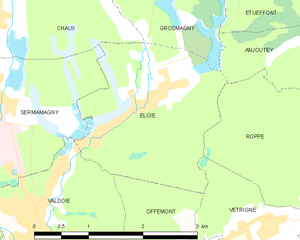
Éloie
- commune in Territoire de Belfort, France
- Country:
- Postal Code: 90300
- Coordinates: 47° 41' 26" N, 6° 52' 25" E
- GPS tracks (wikiloc): [Link]
- Area: 5.55 sq km
- Population: 958
- Web site: [Link]


Bourg-sous-Châtelet
- commune in Territoire de Belfort, France
- Country:
- Postal Code: 90110
- Coordinates: 47° 42' 7" N, 6° 56' 51" E
- GPS tracks (wikiloc): [Link]
- Area: 0.84 sq km
- Population: 109


Étueffont
- commune in Territoire de Belfort, France
- Country:
- Postal Code: 90170
- Coordinates: 47° 43' 8" N, 6° 55' 18" E
- GPS tracks (wikiloc): [Link]
- Area: 12.53 sq km
- Population: 1487
- Web site: [Link]

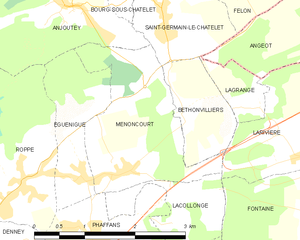
Menoncourt
- commune in Territoire de Belfort, France
 Hiking in Menoncourt
Menoncourt is a charming commune located in the Doubs department in eastern France, close to the border with Switzerland. While it may not be widely recognized as a hiking destination, the surrounding region offers a variety of trails and scenic landscapes ideal for outdoor enthusiasts....
- Country:
- Postal Code: 90150
- Coordinates: 47° 40' 14" N, 6° 56' 38" E
- GPS tracks (wikiloc): [Link]
- Area: 4.7 sq km
- Population: 397
- Web site: [Link]


Grosmagny
- commune in Territoire de Belfort, France
- Country:
- Postal Code: 90200
- Coordinates: 47° 43' 20" N, 6° 53' 2" E
- GPS tracks (wikiloc): [Link]
- Area: 9.46 sq km
- Population: 547

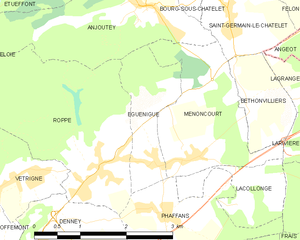
Eguenigue
- commune in Territoire de Belfort, France
Hiking in Eguenigue
It seems there might be a misunderstanding, as "Eguenigue" doesn't appear to correspond to any well-known hiking destination or region that I'm familiar with. It's possible that the name may be misspelled or it refers to a lesser-known location....
- Country:
- Postal Code: 90150
- Coordinates: 47° 40' 13" N, 6° 56' 5" E
- GPS tracks (wikiloc): [Link]
- Area: 2.49 sq km
- Population: 281


Romagny-sous-Rougemont
- commune in Territoire de Belfort, France
- Country:
- Postal Code: 90110
- Coordinates: 47° 43' 6" N, 6° 58' 6" E
- GPS tracks (wikiloc): [Link]
- Area: 2.47 sq km
- Population: 211


Saint-Germain-le-Châtelet
- commune in Territoire de Belfort, France
- Country:
- Postal Code: 90110
- Coordinates: 47° 41' 46" N, 6° 57' 31" E
- GPS tracks (wikiloc): [Link]
- Area: 3.36 sq km
- Population: 640


Roppe
- commune in Territoire de Belfort, France
Hiking in Roppe
Roppe, located in France's Haute-Saône department in the Bourgogne-Franche-Comté region, offers a charming environment for hiking enthusiasts. While it may not be as widely recognized as some larger hiking destinations, Roppe and its surroundings provide a peaceful experience for those looking to explore natural landscapes....
- Country:
- Postal Code: 90380
- Coordinates: 47° 40' 14" N, 6° 55' 10" E
- GPS tracks (wikiloc): [Link]
- Area: 7.43 sq km
- Population: 1005

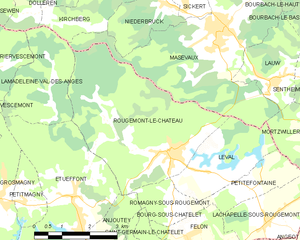
Rougemont-le-Château
- commune in Territoire de Belfort, France
- Country:
- Postal Code: 90110
- Coordinates: 47° 44' 8" N, 6° 58' 2" E
- GPS tracks (wikiloc): [Link]
- Area: 16.64 sq km
- Population: 1456
- Web site: [Link]